Difference between revisions of "2010-01-30 -37 144"
imported>Kozz |
m (More specific location) |
||
| (5 intermediate revisions by 2 users not shown) | |||
| Line 1: | Line 1: | ||
| − | |||
| − | |||
| − | |||
| − | |||
| − | |||
| − | |||
{{meetup graticule | {{meetup graticule | ||
| − | | lat= | + | | lat=-37 |
| − | | lon= | + | | lon=144 |
| − | | date= | + | | date=2010-01-30 |
}} | }} | ||
| − | |||
| − | |||
== Location == | == Location == | ||
In a field just south of the Puckapanyal military base, close to Heathcote and Tooborac, Victoria | In a field just south of the Puckapanyal military base, close to Heathcote and Tooborac, Victoria | ||
| Line 21: | Line 13: | ||
== Plans == | == Plans == | ||
| − | Head to the hashpoint en route on a road trip; hope there's a farmer nearby to give us access to the field. | + | Head to the hashpoint en route on a road trip; hope there's a farmer nearby to give us access to the field. Day one of a [[2010-01-31 -35 144|two-day road trip]]. |
== Expedition == | == Expedition == | ||
| Line 47: | Line 39: | ||
== Photos == | == Photos == | ||
| − | |||
<gallery perrow="4"> | <gallery perrow="4"> | ||
| − | Image: | + | Image:2010-01-30 -37 144 Dry fields, dry hills (Medium).JPG|Bone dry - 4mm of rain in the past month |
| − | Image: | + | Image:2010-01-30 -37 144 En route (Medium).JPG | En route to the hashpoint |
| + | Image: 2010-01-30 -37 144 Road to nowhere (Medium).JPG | Gravel roads | ||
| + | Image: 2010-01-30 -37 144 Gravel roads (Medium).JPG | More gravel roads, yay! | ||
| + | Image:2010-01-30 -37 144 More dryness (Medium).JPG | More dryness | ||
| + | Image: 2010-01-30 -37 144 Off the main road (Medium).JPG | Onto the side roads | ||
| + | Image: 2010-01-30 -37 144 Poor sheeps (Medium).JPG | Local stock suffering in the sunshine | ||
| + | Image:2010-01-30 -37 144 Final measurement (Medium).JPG |Hashpoint is thataway | ||
| + | Image:2010-01-30 -37 144 90m short (Medium).JPG|Foiled again - 92 metres this time | ||
| + | Image:2010-01-30 -37 144 Geotrash (Medium).JPG | Geotrash in its natural environment | ||
| + | Image: 2010-01-30 -37 144 Sunburnt country (Medium).JPG | I love a sunburnt country etc etc | ||
| + | Image:2010-01-30--37-144-Panoramaa-(Medium).jpg | Panorama of the hashpoint field | ||
</gallery> | </gallery> | ||
| − | |||
| − | |||
| − | |||
| − | |||
| − | |||
| − | |||
| − | |||
| − | |||
| − | |||
| − | |||
| − | |||
[[Category:Expeditions]] | [[Category:Expeditions]] | ||
| − | |||
[[Category:Expeditions with photos]] | [[Category:Expeditions with photos]] | ||
| − | |||
| − | |||
| − | |||
| − | |||
| − | |||
| − | |||
| − | |||
| − | |||
| − | |||
[[Category:Coordinates not reached]] | [[Category:Coordinates not reached]] | ||
| − | |||
| − | |||
[[Category:Not reached - No public access]] | [[Category:Not reached - No public access]] | ||
| − | + | ||
| − | + | {{consecutive geohash | |
| − | -- | + | | count = 2 |
| + | | latitude = -37 | ||
| + | | longitude = 144 | ||
| + | | date = 2010-01-30 | ||
| + | | name = Kozz | ||
| + | }} | ||
| + | {{drag-along | ||
| + | | latitude = -37 | ||
| + | | longitude = 144 | ||
| + | | date = 2010-01-30 | ||
| + | | partner = on irritated partner | ||
| + | | name = Kozz | ||
| + | }} | ||
| + | {{location|AU|VIC|MC}} | ||
Latest revision as of 11:56, 1 August 2020
| Sat 30 Jan 2010 in -37,144: -37.0325600, 144.9027781 geohashing.info google osm bing/os kml crox |
Location
In a field just south of the Puckapanyal military base, close to Heathcote and Tooborac, Victoria
Participants
Plans
Head to the hashpoint en route on a road trip; hope there's a farmer nearby to give us access to the field. Day one of a two-day road trip.
Expedition
Road trip!
We were heading to a small town north of the New South Wales border, so naturally before making any rash decisions like committing to an arrival time or figuring out if the car needed gas, I got onto the Geohash wiki and checked out the accessibility of todays hashes.
with the graticule high in the north-east, the graticule west of my home was up for exploration. Closer inspection showed that the point was in the middle of a field just south of a military base close to the border. Not much of a detour off our route, but just as we left home my partner informed me we had to arrive in NSW by early afternoon for an appointment, preventing a lengthy stay and explore of the area.
Heathcote, which isn't too far north of where we were, has gained a bit of press recently after a millionaire member of the Rockefeller family (apparently unrelated to the Rockefellers of North America) went missing between the airport and his home in Melbourne during the week. The police were out in force in Heathcote earlier in the week searching for his body. Not sure if there's an award for geohashing under the guise of helping a current police investigation.
Once again, private property prevented us from getting to the actual physical hash point. It's a cause of some frustration; in a lot of the cases where the hash falls onto some farmer's property way out in the wops, it's impossible to tell who's property it is and therefore who too ask if you can access their land. I've yet to see a kindly farmer ploughing a field nearby who can authorise access.
I'm a property owner myself and as such am loathe to trespass on somebody else's, and I grew up in the country, so am even more loathe to trespass on fields with livestock in them. So, despite the fact I could clearly see the hashpoint and could have easily jumped the fence and walked 90m to the point without anyone being the wiser, I did not.
I did however collect one very small piece of geotrash and took a panorama of the sunburnt field in which the hashpoint sat.
There was another hashpoint further north in the Deniliquin graticule, but it would've involved at least an hour's detour which didn't fit in with the schedule.
Tracklog
Photos
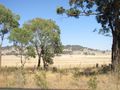
Bone dry - 4mm of rain in the past month
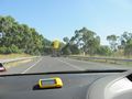
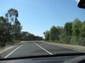
En route to the hashpoint
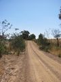
Gravel roads
More gravel roads, yay!
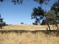
More dryness
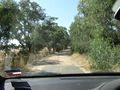
Onto the side roads
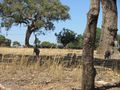
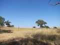
Local stock suffering in the sunshine
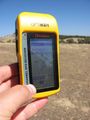
Hashpoint is thataway
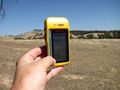
Foiled again - 92 metres this time
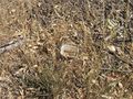
Geotrash in its natural environment
I love a sunburnt country etc etc
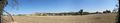
Panorama of the hashpoint field
.JPG)
.JPG)
.JPG)
.JPG)
.JPG)
.JPG)
.JPG)
.JPG)
.JPG)
.JPG)
.JPG)
Kozz earned the Consecutive geohash achievement
|
Kozz earned the Drag-along achievement
|