Difference between revisions of "2010-01-30 44 -120"
From Geohashing
imported>Nn2s2u |
imported>Jiml m (Adjust result codes) |
||
| Line 1: | Line 1: | ||
| − | |||
| − | |||
| − | |||
| − | |||
| − | |||
{{meetup graticule | {{meetup graticule | ||
| lat=44 | | lat=44 | ||
| Line 18: | Line 13: | ||
== Participants == | == Participants == | ||
| − | [[User:Nn2s2u|Nn2s2u]] | + | * [[User:Nn2s2u|Nn2s2u]] |
== Plans == | == Plans == | ||
| Line 38: | Line 33: | ||
[[Category:Coordinates reached]] [[Category:Expeditions with photos]] | [[Category:Coordinates reached]] [[Category:Expeditions with photos]] | ||
| − | |||
| − | |||
| − | |||
| − | |||
| − | |||
| − | |||
| − | |||
| − | |||
| − | |||
| − | |||
| − | |||
| − | |||
| − | |||
| − | |||
| − | |||
| − | |||
| − | |||
| − | |||
| − | |||
| − | |||
| − | |||
| − | |||
| − | |||
| − | |||
| − | |||
| − | |||
| − | |||
| − | |||
| − | |||
| − | |||
| − | |||
| − | |||
| − | |||
| − | |||
| − | |||
| − | |||
Revision as of 03:27, 15 May 2010
| Sat 30 Jan 2010 in 44,-120: 44.0325600, -120.9027781 geohashing.info google osm bing/os kml crox |
Location
In the Millican OHV trail system, on some well used range land, about 200m from a OHV trail.
Participants
Plans
Will try to be there at normal time.
Expedition
Not much to say about this one, except that it is, presumably, the first time that the Prineville graticule hash point has been found. I also brought a camera along, for once.
Photos
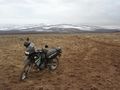
My trusty mount, parked about 200m from the hash point.
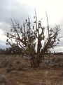
Juniperus occidentalis var. shoealis

