Difference between revisions of "2010-02-06 36 -87"
From Geohashing
imported>SporkOnABike (→Photos) |
m (per Renaming Proposal) |
||
| (4 intermediate revisions by 3 users not shown) | |||
| Line 1: | Line 1: | ||
| − | |||
| − | |||
| − | |||
| − | |||
{{meetup graticule | {{meetup graticule | ||
| lat=36 | | lat=36 | ||
| Line 9: | Line 5: | ||
}} | }} | ||
| − | |||
__NOTOC__ | __NOTOC__ | ||
== Location == | == Location == | ||
| Line 16: | Line 11: | ||
== Participants == | == Participants == | ||
| − | [[User:SporkOnABike|Spork (on a bike)]] | + | [[User:SporkOnABike|Spork (on a bike)]] went, along with [[User:Tuna|Tuna!]] |
== Plans == | == Plans == | ||
| Line 25: | Line 20: | ||
[[User:SporkOnABike|Spork (on a bike)]] and [[User:Tuna|Tuna!]] were the only ones there, but it beat sitting around the house! | [[User:SporkOnABike|Spork (on a bike)]] and [[User:Tuna|Tuna!]] were the only ones there, but it beat sitting around the house! | ||
| − | |||
| − | |||
| − | |||
| − | + | == Route == | |
211 West from The Trace (toward Iron Mountain Camp), then South on 206. If you don't have an LBL map, get one at any welcome station. | 211 West from The Trace (toward Iron Mountain Camp), then South on 206. If you don't have an LBL map, get one at any welcome station. | ||
| Line 40: | Line 32: | ||
| latitude = 36 | | latitude = 36 | ||
| longitude = -87 | | longitude = -87 | ||
| − | | date = | + | | date = 2010-02-06 |
| name = SporkOnABike | | name = SporkOnABike | ||
| image = CRW 8601.JPG | | image = CRW 8601.JPG | ||
| Line 48: | Line 40: | ||
| latitude = 36 | | latitude = 36 | ||
| longitude = -87 | | longitude = -87 | ||
| − | | date = | + | | date = 2010-02-06 |
| name = Tuna | | name = Tuna | ||
}} | }} | ||
| − | {{ | + | {{Graticule unlocked |
| latitude = 36 | | latitude = 36 | ||
| longitude = -87 | | longitude = -87 | ||
| − | | date = | + | | date = 2010-02-06 |
| name = SporkOnABike | | name = SporkOnABike | ||
| image = CRW 8601.JPG | | image = CRW 8601.JPG | ||
}} | }} | ||
| − | {{ | + | {{Graticule unlocked |
| latitude = 36 | | latitude = 36 | ||
| longitude = -87 | | longitude = -87 | ||
| − | | date = | + | | date = 2010-02-06 |
| name = Tuna | | name = Tuna | ||
| Line 74: | Line 66: | ||
Image:CRW 8605.JPG|Tree engulfed barbed wire | Image:CRW 8605.JPG|Tree engulfed barbed wire | ||
</gallery> | </gallery> | ||
| − | |||
| − | |||
| − | |||
| − | |||
| − | |||
| − | |||
| − | |||
| − | |||
[[Category:Coordinates reached]] | [[Category:Coordinates reached]] | ||
[[Category:Expeditions]] | [[Category:Expeditions]] | ||
[[Category:Expeditions with photos]] | [[Category:Expeditions with photos]] | ||
| − | + | {{location|US|TN|SA}} | |
| − | |||
| − | |||
| − | |||
| − | |||
| − | |||
| − | |||
| − | |||
| − | |||
| − | |||
| − | |||
| − | |||
| − | |||
| − | |||
| − | |||
| − | |||
Latest revision as of 06:16, 20 March 2024
| Sat 6 Feb 2010 in 36,-87: 36.6074741, -87.9902612 geohashing.info google osm bing/os kml crox |
Location
Just off road 206 in Southern LBL near Barrow Cemetery
Participants
Spork (on a bike) went, along with Tuna!
Plans
SporkOnABike
Carpool to LBL, drive/bike to the road, walk the rest of the way (about half a mile). It's near some of the North-South Trail, so some hiking and/or camping may be in order if the weather cooperates. Hopefully, we can at least have a bonfire.
Expedition
Spork (on a bike) and Tuna! were the only ones there, but it beat sitting around the house!
Route
211 West from The Trace (toward Iron Mountain Camp), then South on 206. If you don't have an LBL map, get one at any welcome station.
Tracklog
Achievements
SporkOnABike earned the Land geohash achievement
|
Tuna earned the Land geohash achievement
|
SporkOnABike earned the Graticule Unlocked Achievement
|
Tuna earned the Graticule Unlocked Achievement
|
Photos
Signage
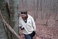
Spork
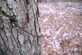
Tree engulfed barbed wire


