Difference between revisions of "2010-02-06 51 4"
imported>Jiml m (Add result category) |
imported>FippeBot m (Location) |
||
| (5 intermediate revisions by 4 users not shown) | |||
| Line 1: | Line 1: | ||
| − | + | [[Image:2010-02-06-51-4a.jpg|thumb|left]] | |
| − | |||
| − | |||
| − | |||
| − | |||
{{meetup graticule | {{meetup graticule | ||
| lat=51 | | lat=51 | ||
| Line 11: | Line 7: | ||
}} | }} | ||
| − | |||
__NOTOC__ | __NOTOC__ | ||
== Location == | == Location == | ||
| − | + | On a piece of farmland halfway between Dongen and Tilburg. | |
== Participants == | == Participants == | ||
| − | + | * [[User:CO2|CO2]] | |
| − | * [[User: | ||
== Plans == | == Plans == | ||
| − | I ([[User: | + | I ([[User:CO2|CO2]]) am planning to go there tomorrow afternoon. It is quite nearby my current location. And I can borrow my mother's car and GPS device, so all will be great. |
== Expedition == | == Expedition == | ||
| − | + | Most of the way there I knew, only the last part was unknown. It was a tiny muddy road going to nowhere, splitting off from a large road. I actually had to turn 'round a bit past the sideroad, so I could go into the sideroad when it was at my right side. After a bit of walking around with my not-so-good GPS device (it's meant for car navigation so it doesn't like small distance movements) I found the exact spot. It was in the middle of a bit of farmland. I wondered if I was allowed to go on there but there wasn't anybody there so I decided what the hell. Right at the hashpoint was this huuuge puddle, and I was mad enough to try and get closer to the hashpoint. That gave me wet socks. But I think I got within 5 meters of the spot. I hung up a marker on the nearest tree and after taking a few more pictures I decided to leave. | |
| − | |||
| − | |||
== Photos == | == Photos == | ||
| − | + | ||
<gallery perrow="4"> | <gallery perrow="4"> | ||
| − | Image: | + | Image:2010-02-06-51-4a.jpg | Foggy day. The hash should be somewhere on that farmland. |
| − | Image: | + | Image:2010-02-06-51-4b.jpg | After some searching I found it was right there in that puddle. |
| + | Image:2010-02-06-51-4c.jpg | Me getting wet socks attempting to get as close as possible. | ||
| + | Image:2010-02-06-51-4d.jpg | Of course, proof is needed. | ||
| + | Image:2010-02-06-51-4e.jpg | Homemade marker with "The internet was here" in Dutch. | ||
| + | Image:2010-02-06-51-4f.jpg | Another corner of the bit of farmland. | ||
| + | Image:2010-02-06-51-4g.jpg | The small muddy road next to the farmland. The large road is there at the end. | ||
</gallery> | </gallery> | ||
| − | |||
| − | |||
| − | |||
| − | |||
| − | |||
| − | |||
| − | |||
| − | |||
| − | |||
| − | |||
| − | |||
| − | |||
[[Category:Expeditions]] | [[Category:Expeditions]] | ||
| − | + | [[Category:Expeditions with photos]] | |
| − | [[Category:Expeditions with photos]] | ||
| − | |||
| − | |||
| − | |||
| − | |||
| − | |||
[[Category:Coordinates reached]] | [[Category:Coordinates reached]] | ||
| − | + | {{location|NL|NB}} | |
| − | |||
| − | |||
| − | |||
| − | |||
| − | |||
| − | |||
| − | |||
| − | |||
| − | |||
| − | |||
| − | |||
| − | |||
Latest revision as of 00:46, 9 August 2019

| Sat 6 Feb 2010 in 51,4: 51.6074741, 4.9902612 geohashing.info google osm bing/os kml crox |
Location
On a piece of farmland halfway between Dongen and Tilburg.
Participants
Plans
I (CO2) am planning to go there tomorrow afternoon. It is quite nearby my current location. And I can borrow my mother's car and GPS device, so all will be great.
Expedition
Most of the way there I knew, only the last part was unknown. It was a tiny muddy road going to nowhere, splitting off from a large road. I actually had to turn 'round a bit past the sideroad, so I could go into the sideroad when it was at my right side. After a bit of walking around with my not-so-good GPS device (it's meant for car navigation so it doesn't like small distance movements) I found the exact spot. It was in the middle of a bit of farmland. I wondered if I was allowed to go on there but there wasn't anybody there so I decided what the hell. Right at the hashpoint was this huuuge puddle, and I was mad enough to try and get closer to the hashpoint. That gave me wet socks. But I think I got within 5 meters of the spot. I hung up a marker on the nearest tree and after taking a few more pictures I decided to leave.
Photos
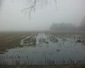
Foggy day. The hash should be somewhere on that farmland.
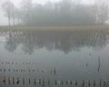
After some searching I found it was right there in that puddle.
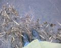
Me getting wet socks attempting to get as close as possible.
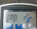
Of course, proof is needed.
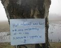
Homemade marker with "The internet was here" in Dutch.
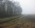
Another corner of the bit of farmland.
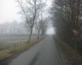
The small muddy road next to the farmland. The large road is there at the end.


