Difference between revisions of "2010-02-09 39 -111"
imported>GeohashGirls (Provo, Utah) |
imported>FippeBot m (Location) |
||
| (4 intermediate revisions by 2 users not shown) | |||
| Line 1: | Line 1: | ||
| − | |||
| − | |||
| − | |||
| − | |||
| − | |||
| − | |||
{{meetup graticule | {{meetup graticule | ||
| − | | lat= | + | | lat=39 |
| lon=-111 | | lon=-111 | ||
| date=2010-02-09 | | date=2010-02-09 | ||
}} | }} | ||
| − | |||
__NOTOC__ | __NOTOC__ | ||
== Location == | == Location == | ||
| − | |||
Provo, UT | Provo, UT | ||
== Participants == | == Participants == | ||
| − | |||
One of the [[User:GeohashGirls|Geohash Girls]] and Friends | One of the [[User:GeohashGirls|Geohash Girls]] and Friends | ||
| − | |||
| − | |||
| − | |||
== Expedition == | == Expedition == | ||
| − | |||
We started out on what we thought would be a fairly easy Geohash in the early afternoon. Upon getting there, we realized we would have to either drive up the railroad tracks or walk a longer distance across a field to reach the coordinants. It probably wouldn't be best to drive up the tracks (besides the fact that it's illegal) since some truck was stationed just off the side of the road. So we drove around to the other side and started across the field. We got half way across and my shoes were already covered in mud. We were so close, until we came to a stream that crossed straight through our path. We were only 100 feet away! The stream was too wide to cross. It was a failed attempt at reaching the Geohash. :( We headed back to the truck. Then we realized we weren't the only ones in the field. Five or six horses were coming over to greet us. Now I'm not the biggest horse fan, especially when their owner is not around. It seemed like they were rounding us up at first. I finally reached out to pet one which seemed to calm both of us down. We hurried to cross the fence- the horses escorting us the rest of the way there. We made friends with the horses! As we were driving away, the horses were running along side the fence near our truck to see us off. Definitely worth the adventure. | We started out on what we thought would be a fairly easy Geohash in the early afternoon. Upon getting there, we realized we would have to either drive up the railroad tracks or walk a longer distance across a field to reach the coordinants. It probably wouldn't be best to drive up the tracks (besides the fact that it's illegal) since some truck was stationed just off the side of the road. So we drove around to the other side and started across the field. We got half way across and my shoes were already covered in mud. We were so close, until we came to a stream that crossed straight through our path. We were only 100 feet away! The stream was too wide to cross. It was a failed attempt at reaching the Geohash. :( We headed back to the truck. Then we realized we weren't the only ones in the field. Five or six horses were coming over to greet us. Now I'm not the biggest horse fan, especially when their owner is not around. It seemed like they were rounding us up at first. I finally reached out to pet one which seemed to calm both of us down. We hurried to cross the fence- the horses escorting us the rest of the way there. We made friends with the horses! As we were driving away, the horses were running along side the fence near our truck to see us off. Definitely worth the adventure. | ||
== Tracklog == | == Tracklog == | ||
| − | |||
<gallery> | <gallery> | ||
Image: 2010-02-09 40 -111 track.PNG | Image: 2010-02-09 40 -111 track.PNG | ||
| + | Image: 2010-02-09_40_-111_track1.png | ||
</gallery> | </gallery> | ||
== Photos == | == Photos == | ||
| − | |||
| − | |||
| − | |||
<gallery perrow="4"> | <gallery perrow="4"> | ||
| + | Image: 2010-02-09 IMG 0468.jpg| The stream | ||
Image: 2010-02-09_-111_40.png| Making Friends with the Horses | Image: 2010-02-09_-111_40.png| Making Friends with the Horses | ||
</gallery> | </gallery> | ||
| − | |||
| − | |||
| − | |||
| − | |||
| − | |||
| − | |||
| − | |||
| − | |||
| − | |||
| − | |||
| − | |||
| − | |||
| − | |||
[[Category:Expeditions]] | [[Category:Expeditions]] | ||
| − | |||
[[Category:Expeditions with photos]] | [[Category:Expeditions with photos]] | ||
| − | |||
| − | |||
| − | |||
| − | |||
| − | |||
| − | |||
| − | |||
| − | |||
[[Category:Coordinates not reached]] | [[Category:Coordinates not reached]] | ||
| − | |||
[[Category:Not reached - Mother Nature]] | [[Category:Not reached - Mother Nature]] | ||
| − | + | {{location|US|UT|JU}} | |
| − | |||
| − | |||
| − | |||
| − | |||
| − | |||
Latest revision as of 03:06, 6 August 2019
| Tue 9 Feb 2010 in 39,-111: 39.8253974, -111.8655267 geohashing.info google osm bing/os kml crox |
Location
Provo, UT
Participants
One of the Geohash Girls and Friends
Expedition
We started out on what we thought would be a fairly easy Geohash in the early afternoon. Upon getting there, we realized we would have to either drive up the railroad tracks or walk a longer distance across a field to reach the coordinants. It probably wouldn't be best to drive up the tracks (besides the fact that it's illegal) since some truck was stationed just off the side of the road. So we drove around to the other side and started across the field. We got half way across and my shoes were already covered in mud. We were so close, until we came to a stream that crossed straight through our path. We were only 100 feet away! The stream was too wide to cross. It was a failed attempt at reaching the Geohash. :( We headed back to the truck. Then we realized we weren't the only ones in the field. Five or six horses were coming over to greet us. Now I'm not the biggest horse fan, especially when their owner is not around. It seemed like they were rounding us up at first. I finally reached out to pet one which seemed to calm both of us down. We hurried to cross the fence- the horses escorting us the rest of the way there. We made friends with the horses! As we were driving away, the horses were running along side the fence near our truck to see us off. Definitely worth the adventure.
Tracklog


Photos
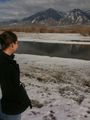
The stream
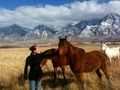
Making Friends with the Horses

