Difference between revisions of "2010-02-21 52 -7"
imported>JRK (Created page with '{{meetup graticule | lat=52 | lon=-7 | date=2010-02-21 | graticule_name=Waterford, Ireland | graticule_link=Waterford, Ireland}} == Participant == JRK == Expeditio…') |
imported>JRK |
||
| Line 25: | Line 25: | ||
<gallery> | <gallery> | ||
| − | Image:Jrk_g6_1. | + | Image:Jrk_g6_1.jpg|The strand in Tramore. |
| − | Image:Jrk_g6_1a. | + | Image:Jrk_g6_1a.jpg|Same place, looking to the west. |
| − | Image:Jrk_g6_2. | + | Image:Jrk_g6_2.jpg|Bog of Fenor. |
| − | Image:Jrk_g6_3. | + | Image:Jrk_g6_3.jpg|I had your uncle for dinner yesterday. |
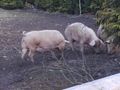
| − | Image:Jrk_g6_4. | + | Image:Jrk_g6_4.jpg|Here you can hunt pigs, cows and if you're lucky you can even shot a tractor! |
| − | Image:Jrk_g6_4a. | + | Image:Jrk_g6_4a.jpg|Loch Bhaile, I'm really proud of this picture :). |
| − | Image:Jrk_g6_5hash. | + | Image:Jrk_g6_5hash.jpg|Surprise, surprise, it's a field once again. |
| − | Image:Jrk_g6_6. | + | Image:Jrk_g6_6.jpg|Walking here is rather hazardous. |
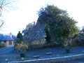
| − | Image:Jrk_g6_7. | + | Image:Jrk_g6_6a.jpg|Knockeen Dolmen. Damn you, dogs! |
| − | Image:Jrk_g6_8. | + | Image:Jrk_g6_7.jpg|Nice decoration. |
| + | Image:Jrk_g6_8.jpg|I will have your uncle for dinner tomorrow. | ||
</gallery> | </gallery> | ||
Revision as of 00:51, 22 February 2010
| Sun 21 Feb 2010 in Waterford, Ireland: 52.1965597, -7.1560514 geohashing.info google osm bing/os kml crox |
Participant
Expedition
Too tired to write a full entry, so such a bunch of quick comments: -the day was sunny and warm, so I decided to go for a walk -I took a bus from Waterford to Tramore (on the Atlantic coast) and decided to walk home, on the way visiting hash -I was supposed to use the map and my wits + crazy survival skills to reach the point -my wits + crazy survival skills made me go west instead of north and I realized that after 2 hours and after walking 10 km in wrong direction -did I started to cry and abandoned the quest? well, there was some crying but there was no way to abandon as I was in the middle of nowhere ;-) -I got to the nearest village (it was Fenor) and found myself on the map again -from now on it was easy (if tiring) -a lot of baby animals: pigs, lambs, horses, cuuute -I found a mysterious Irish lake, excuse me - loch -I wanted to visit Knockeen Dolmen, as it was around 1km from the hash point - http://www.megalithicireland.com/Knockeen%20Dolmen.htm, but it was guarded by two big and angry dogs, so I just made a picture from far away -after finally geting home I was exhousted (I didn't expect it to take so long - 7 hours in total) -checking my route on google maps revealed I made 23 km - my new record :).
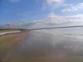
The strand in Tramore.
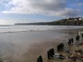
Same place, looking to the west.
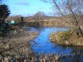
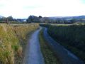
Bog of Fenor.
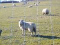
I had your uncle for dinner yesterday.
Here you can hunt pigs, cows and if you're lucky you can even shot a tractor!
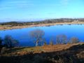
Loch Bhaile, I'm really proud of this picture :).
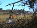
- Jrk g6 5hash.jpg
Surprise, surprise, it's a field once again.
Walking here is rather hazardous.
Knockeen Dolmen. Damn you, dogs!
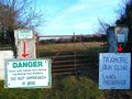
Nice decoration.
I will have your uncle for dinner tomorrow.


