Difference between revisions of "2010-03-12 44 -123"
imported>Taper |
imported>FippeBot m (Location) |
||
| (6 intermediate revisions by one other user not shown) | |||
| Line 15: | Line 15: | ||
== Location == | == Location == | ||
<!-- where you've surveyed the hash to be --> | <!-- where you've surveyed the hash to be --> | ||
| + | Millrace Park in Springfield, Oregon, south of the western widening of the millrace. | ||
| + | |||
== Participants == | == Participants == | ||
<!-- who attended --> | <!-- who attended --> | ||
| + | [[User:Taper|Taper]] | ||
== Plans == | == Plans == | ||
<!-- what were the original plans --> | <!-- what were the original plans --> | ||
| + | Going to head out to be there at 4:00. Will stay a while. Not particularly expecting anybody else, but hey. | ||
== Expedition == | == Expedition == | ||
<!-- how it all turned out. your narrative goes here. --> | <!-- how it all turned out. your narrative goes here. --> | ||
| + | Well, I went because it was close to my home -- and discovered that the nice little pond and stream on the map are very full and flowing fast this time of year -- and there's no bridge to get to the hash from the north side of the stream. The trails that get to stream level are very rudimentary and it would be too hazardous to attempt a crossing even were I physically capable of it. | ||
| + | |||
| + | (Southern access to the hash point is blocked by private property with a high security fence.) | ||
| + | |||
| + | My closest approach was just over 30 meters from the hash point. I seem to have taken any actual tracking software off my Android phone, but the photos I took with it are geotagged. According to those, the closest I got was 44.04518056N, 123.02514444W. | ||
| + | |||
| + | I'll definitely be watching for more hashes that I'll be able to attempt, though! | ||
== Tracklog == | == Tracklog == | ||
<!-- if your GPS device keeps a log, you may post a link here --> | <!-- if your GPS device keeps a log, you may post a link here --> | ||
| + | [None, but see the photos' EXIF tags below.] | ||
== Photos == | == Photos == | ||
| Line 33: | Line 45: | ||
--> | --> | ||
<gallery perrow="4"> | <gallery perrow="4"> | ||
| + | Image:Tw-gh_2010-03-12_-123_44-A03_panorama.jpg | A panoramic view of the millrace from downstream. As far in as I could walk. | ||
| + | Image:Tw-gh_2010-03-12_-123_44-A02_pointer.jpg | Part of that panorama with an arrow showing what I think is the actual hash location. | ||
| + | Image:Tw-gh_2010-03-12_-123_44-marker.jpg | Too bad I didn't make it; I'd made this spiffy marker, too... | ||
</gallery> | </gallery> | ||
| Line 38: | Line 53: | ||
<!-- =============== USEFUL CATEGORIES FOLLOW ================ | <!-- =============== USEFUL CATEGORIES FOLLOW ================ | ||
Delete the next line ONLY if you have chosen the appropriate categories below. If you are unsure, don't worry. People will read your report and help you with the classification. --> | Delete the next line ONLY if you have chosen the appropriate categories below. If you are unsure, don't worry. People will read your report and help you with the classification. --> | ||
| − | |||
<!-- Potential categories. Please include all the ones appropriate to your expedition --> | <!-- Potential categories. Please include all the ones appropriate to your expedition --> | ||
| Line 45: | Line 59: | ||
--> | --> | ||
| + | [[Category:Expeditions]] | ||
| + | [[Category:Expeditions with photos]] | ||
<!-- An actual expedition: | <!-- An actual expedition: | ||
| − | + | ||
-- and one or more of -- | -- and one or more of -- | ||
[[Category:Expeditions with photos]] | [[Category:Expeditions with photos]] | ||
| Line 56: | Line 72: | ||
[[Category:Coordinates reached]] | [[Category:Coordinates reached]] | ||
--> | --> | ||
| + | |||
| + | [[Category:Coordinates not reached]] | ||
| + | [[Category:Not reached - Mother Nature]] | ||
<!-- or if you failed :( | <!-- or if you failed :( | ||
| Line 65: | Line 84: | ||
[[Category:Failed - Did not attempt]] | [[Category:Failed - Did not attempt]] | ||
--> | --> | ||
| + | {{location|US|OR|LE}} | ||
Latest revision as of 01:10, 9 August 2019
| Fri 12 Mar 2010 in 44,-123: 44.0449015, -123.0250764 geohashing.info google osm bing/os kml crox |
Location
Millrace Park in Springfield, Oregon, south of the western widening of the millrace.
Participants
Plans
Going to head out to be there at 4:00. Will stay a while. Not particularly expecting anybody else, but hey.
Expedition
Well, I went because it was close to my home -- and discovered that the nice little pond and stream on the map are very full and flowing fast this time of year -- and there's no bridge to get to the hash from the north side of the stream. The trails that get to stream level are very rudimentary and it would be too hazardous to attempt a crossing even were I physically capable of it.
(Southern access to the hash point is blocked by private property with a high security fence.)
My closest approach was just over 30 meters from the hash point. I seem to have taken any actual tracking software off my Android phone, but the photos I took with it are geotagged. According to those, the closest I got was 44.04518056N, 123.02514444W.
I'll definitely be watching for more hashes that I'll be able to attempt, though!
Tracklog
[None, but see the photos' EXIF tags below.]
Photos
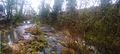
A panoramic view of the millrace from downstream. As far in as I could walk.
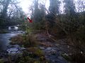
Part of that panorama with an arrow showing what I think is the actual hash location.
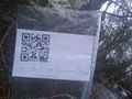
Too bad I didn't make it; I'd made this spiffy marker, too...


