Difference between revisions of "2010-03-21 42 -72"
imported>Sara (expand subst:expedition) |
imported>FippeBot m (Location) |
||
| (2 intermediate revisions by one other user not shown) | |||
| Line 1: | Line 1: | ||
| − | + | [[Image:2010-03-21_42_-72_view.jpg|thumb|right]] | |
| − | |||
| − | |||
| − | [[Image: | ||
| − | |||
| − | |||
| − | |||
{{meetup graticule | {{meetup graticule | ||
| lat=42 | | lat=42 | ||
| Line 12: | Line 6: | ||
}} | }} | ||
| − | |||
__NOTOC__ | __NOTOC__ | ||
== Location == | == Location == | ||
| − | + | ||
| + | In Fannie Stebbins Wildlife Refuge in Longmeadow, MA. | ||
== Participants == | == Participants == | ||
| − | |||
| − | + | [[User:Sara|Sara]] | |
| − | |||
== Expedition == | == Expedition == | ||
| − | |||
| − | + | This hashpoint is exactly 1.609 km from my house. I have been coveting the Walk Geohash ribbon for months, and this looked like the time to get it. I didn't bring the children because although they're great companions, they can't always make it though the underbrush to the hashpoint. I knew that reaching this hashpoint might require some wading, and I thought that might make it especially challenging for the kids. | |
| − | |||
| − | = | + | Like a lot of people around here, I take walks semi-regularly in the area near the hashpoint. I have walked past the hashpoint (on the road, not in the reeds) many times, but can't prove it. |
| − | + | ||
| − | Image: | + | <gallery perrow="3"> |
| − | -- | + | Image:2010-03-21_42_-72_firstlook.jpg | The hashpoint must be somewhere in the water there, or beyond the water. This is exactly why I didn't bring the children today. |
| − | + | Image:2010-03-21_42_-72_sign.jpg | Before wading to the hash, I walked around the Wildlife Refuge a little. This sign is near the hashpoint. They just don't make floods here like they used to. | |
| + | Image:2010-03-21_42_-72_geese.jpg | Canada Geese about 1km from the hashpoint. I also saw a couple ducks and a lot of songbirds. | ||
</gallery> | </gallery> | ||
| + | See the chewed tree in the goose picture? That becomes relevant later in the story. | ||
| − | + | So after walking around for a little while, I returned to the area of the hashpoint. I looked for a dry way in from the west, and there was none. For some reason it didn't occur to me to look for a dry way in from the east. So, I walked down to the edge of the water, which the GPS said was 60 meters from the hashpoint, took off my shoes and socks, rolled up my pants, and followed my GPS into yucky brackish water up to my ''knees''. There was no way I would have done that if I weren't trying for a new ribbon. | |
| − | |||
| − | |||
| − | + | After a few minutes of very slow progress in the water, the GPS changed its mind about the location of the hashpoint, so that even if the hashpoint were in the water, I could get much closer to it by walking eastward on dry land parallel to the water. | |
| − | |||
| − | |||
| − | |||
| − | < | + | As I started to get out of the water, I saw a ripple - something sizable was swimming towards me. The mystery animal surfaced about 2 or 3 meters from me, and it turned out to be a beaver. I'm a little scared of uncaged large rodents, so we just stared at each other and I didn't take a picture. The beaver eventually turned around, swam to dry land and disappeared. For this work-at-home soccer mom, coming face to face with a beaver counts as excitement. |
| + | |||
| + | So then it turned out that getting my legs all wet was unnecessary; I could have gotten all the way to the hashpoint on nearly dry ground. The hashpoint was about ankle-deep in water. I marked the point, found my shoes, and went home. | ||
| + | |||
| + | == Photos At the Hashpoint == | ||
| + | <gallery perrow="4"> | ||
| + | Image:2010-03-21_42_-72_gps.jpg | The GPS. | ||
| + | Image:2010-03-21_42_-72_grin.jpg | Stupid grin. | ||
| + | Image:2010-03-21_42_-72_marker.jpg | Even I can barely recognize which part is the marker. At least it doesn't disrupt the wildlife refuge too much. | ||
| + | Image:2010-03-21_42_-72_view.jpg | View from the hashpoint | ||
| + | </gallery> | ||
| + | |||
| + | {{Walk geohash | ||
| + | | latitude = 42 | ||
| + | | longitude = -72 | ||
| + | | date = 2010-03-21 | ||
| + | | name = [[User:Sara|Sara]] | ||
| + | | distance = 3.2 km (round trip) | ||
| + | }} | ||
[[Category:Expeditions]] | [[Category:Expeditions]] | ||
| − | |||
[[Category:Expeditions with photos]] | [[Category:Expeditions with photos]] | ||
| − | |||
| − | |||
| − | |||
| − | |||
| − | |||
[[Category:Coordinates reached]] | [[Category:Coordinates reached]] | ||
| − | + | {{location|US|MA|HD}} | |
| − | |||
| − | |||
| − | |||
| − | |||
| − | |||
| − | |||
| − | |||
| − | |||
| − | |||
Latest revision as of 01:17, 9 August 2019

| Sun 21 Mar 2010 in 42,-72: 42.0357446, -72.5903695 geohashing.info google osm bing/os kml crox |
Location
In Fannie Stebbins Wildlife Refuge in Longmeadow, MA.
Participants
Expedition
This hashpoint is exactly 1.609 km from my house. I have been coveting the Walk Geohash ribbon for months, and this looked like the time to get it. I didn't bring the children because although they're great companions, they can't always make it though the underbrush to the hashpoint. I knew that reaching this hashpoint might require some wading, and I thought that might make it especially challenging for the kids.
Like a lot of people around here, I take walks semi-regularly in the area near the hashpoint. I have walked past the hashpoint (on the road, not in the reeds) many times, but can't prove it.
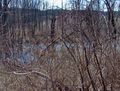
The hashpoint must be somewhere in the water there, or beyond the water. This is exactly why I didn't bring the children today.
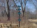
Before wading to the hash, I walked around the Wildlife Refuge a little. This sign is near the hashpoint. They just don't make floods here like they used to.
Canada Geese about 1km from the hashpoint. I also saw a couple ducks and a lot of songbirds.


See the chewed tree in the goose picture? That becomes relevant later in the story.
So after walking around for a little while, I returned to the area of the hashpoint. I looked for a dry way in from the west, and there was none. For some reason it didn't occur to me to look for a dry way in from the east. So, I walked down to the edge of the water, which the GPS said was 60 meters from the hashpoint, took off my shoes and socks, rolled up my pants, and followed my GPS into yucky brackish water up to my knees. There was no way I would have done that if I weren't trying for a new ribbon.
After a few minutes of very slow progress in the water, the GPS changed its mind about the location of the hashpoint, so that even if the hashpoint were in the water, I could get much closer to it by walking eastward on dry land parallel to the water.
As I started to get out of the water, I saw a ripple - something sizable was swimming towards me. The mystery animal surfaced about 2 or 3 meters from me, and it turned out to be a beaver. I'm a little scared of uncaged large rodents, so we just stared at each other and I didn't take a picture. The beaver eventually turned around, swam to dry land and disappeared. For this work-at-home soccer mom, coming face to face with a beaver counts as excitement.
So then it turned out that getting my legs all wet was unnecessary; I could have gotten all the way to the hashpoint on nearly dry ground. The hashpoint was about ankle-deep in water. I marked the point, found my shoes, and went home.
Photos At the Hashpoint
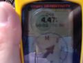
The GPS.

Stupid grin.
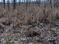
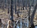
Even I can barely recognize which part is the marker. At least it doesn't disrupt the wildlife refuge too much.
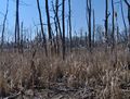
View from the hashpoint


Sara earned the Walk geohash Achievement
|