Difference between revisions of "2010-04-03 45 -123"
imported>Jiml (Fill in data) |
imported>FippeBot m (Location) |
||
| (3 intermediate revisions by one other user not shown) | |||
| Line 14: | Line 14: | ||
__NOTOC__ | __NOTOC__ | ||
== Location == | == Location == | ||
| − | + | East of Mist, Oregon. It appears to be on Timber land. | |
| + | This is no where near Mist County, Minnesota, for you PHC fans. | ||
== Participants == | == Participants == | ||
| − | * [[User:Jiml | + | * [[User:Jiml|Jim]] |
== Plans == | == Plans == | ||
| Line 24: | Line 25: | ||
hashpoint is where the hashpoint chooses to be. | hashpoint is where the hashpoint chooses to be. | ||
| − | + | ||
== Expedition == | == Expedition == | ||
| − | + | Well, Jim eventually set off for this hashpoint, doing some errands on the | |
| + | way. | ||
| + | |||
| + | One of which was to visit tomorrow's [[2010-04-04 45 -122|Portland hashpoint]]. After scouting it | ||
| + | out, I headed west and north to the hashpoint. | ||
| + | |||
| + | The trip was very familiar, and I waved at the entrance road to last week's hashpoint. | ||
| + | |||
| + | I continued on, and passed through Vernonia. On the other side, about 5 miles out, there | ||
| + | was a pullout to the right. Suspecting what it was, I pulled in it, and found | ||
| + | Cedar Creek ML. (Thought I remain unclear on what a ML actually is.) It said it was open to | ||
| + | people if they behaved themselves. However, the gate was closed and locked, | ||
| + | so the car was going to have to stay on this side of the gate. | ||
| + | |||
| + | I wasn't up for a five mile hike to the closest road, and then a certain amount | ||
| + | of bushwacking, so I'm going to declare that Mother Nature has won | ||
| + | another round. | ||
| + | |||
| − | |||
| − | |||
| − | |||
| − | |||
== Photos == | == Photos == | ||
| − | + | ||
| − | |||
| − | |||
<gallery perrow="4"> | <gallery perrow="4"> | ||
| + | Image:2010-04-03_45_-123-gate.jpg | The gate preventing motor vehicle access | ||
| + | Image:2010-04-03_45_-123-area.jpg | A view of the area | ||
</gallery> | </gallery> | ||
| − | |||
| − | [[Category: | + | [[Category:Expeditions]] |
| − | |||
| − | |||
| − | |||
| − | |||
[[Category:Expeditions with photos]] | [[Category:Expeditions with photos]] | ||
| − | + | [[Category:Coordinates not reached]] | |
| − | |||
| − | |||
| − | |||
| − | |||
| − | [[Category:Coordinates reached]] | ||
| − | |||
| − | |||
| − | |||
| − | |||
[[Category:Not reached - Mother Nature]] | [[Category:Not reached - Mother Nature]] | ||
[[Category:Not reached - No public access]] | [[Category:Not reached - No public access]] | ||
| − | + | {{location|US|OR|CL}} | |
| − | |||
| − | |||
Latest revision as of 01:27, 9 August 2019
| Sat 3 Apr 2010 in 45,-123: 45.9957244, -123.1558633 geohashing.info google osm bing/os kml crox |
Location
East of Mist, Oregon. It appears to be on Timber land. This is no where near Mist County, Minnesota, for you PHC fans.
Participants
Plans
For some unclear reason, Jim's inclined to give this one a try. It would make much more sense tomorrow with the errands I have planned, but the hashpoint is where the hashpoint chooses to be.
Expedition
Well, Jim eventually set off for this hashpoint, doing some errands on the way.
One of which was to visit tomorrow's Portland hashpoint. After scouting it out, I headed west and north to the hashpoint.
The trip was very familiar, and I waved at the entrance road to last week's hashpoint.
I continued on, and passed through Vernonia. On the other side, about 5 miles out, there was a pullout to the right. Suspecting what it was, I pulled in it, and found Cedar Creek ML. (Thought I remain unclear on what a ML actually is.) It said it was open to people if they behaved themselves. However, the gate was closed and locked, so the car was going to have to stay on this side of the gate.
I wasn't up for a five mile hike to the closest road, and then a certain amount of bushwacking, so I'm going to declare that Mother Nature has won another round.
Photos
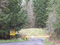
The gate preventing motor vehicle access
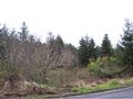
A view of the area

