Difference between revisions of "2010-04-05 42 -72"
imported>Sara (expand subst:expedition) |
imported>FippeBot m (Location) |
||
| (One intermediate revision by one other user not shown) | |||
| Line 1: | Line 1: | ||
| − | + | [[Image:{{{image|2010-04-05_42_-72_view.jpg}}}|thumb|left]] | |
| − | |||
| − | |||
| − | [[Image:{{{image| | ||
| − | |||
| − | |||
| − | |||
{{meetup graticule | {{meetup graticule | ||
| lat=42 | | lat=42 | ||
| Line 12: | Line 6: | ||
}} | }} | ||
| − | |||
__NOTOC__ | __NOTOC__ | ||
== Location == | == Location == | ||
| − | + | ||
| + | At Ludlow Reservoir, in Ludlow, Massachusetts. | ||
== Participants == | == Participants == | ||
| − | |||
| − | + | [[User:Sara|Sara]] | |
| − | |||
== Expedition == | == Expedition == | ||
| − | |||
| − | + | Google maps showed this hashpoint to be very near the path that encircles the reservoir, a little over 1.6km from the parking lot. I decided that given the day's schedule constraints, there wasn't time for the kids to complete that walk, so I drove to the reservoir alone leaving enough time for the 3.2 km walk before I had to pick up the children from school. | |
| − | + | ||
| + | When I got to the reservoir, I discovered that part of the area around the reservoir is closed to the public - the public can't walk all the way around the reservoir. One can reach the hashpoint, but only by walking the long way around the reservoir, about 4.5 or 5 km each way. I had no bike with me. I had about 75 minutes, 9 or 10 km to cover (to the point and back) on a paved path, no running shoes or running clothes, and an out-of-shape pair of legs. | ||
| + | |||
| + | Oooh - suspense. Will she make to the hashpoint in time? | ||
| + | |||
| + | I started off at a slow jog, and surprised myself by jogging all the way to the hashpoint! I guess my legs and lungs remembered that years ago I used to run. It was a very pretty trip through the woods, right next to the reservoir. I wish I had had time to take more pictures. | ||
| + | |||
| + | Near the hashpoint, the path changed from pavement to grass, and the point was within a few meters of the path. | ||
| − | |||
| − | |||
| − | |||
| − | |||
<gallery perrow="4"> | <gallery perrow="4"> | ||
| + | Image:2010-04-05_42_-72_gps.jpg | I got to within the range of accuracy of the GPS. | ||
| + | Image:2010-04-05_42_-72_marker.jpg | ... and marked the spot with pinecones | ||
| + | Image:2010-04-05_42_-72_grin.jpg | ... and took a picture of my stupid mid-jog grin. | ||
| + | Image:2010-04-05_42_-72_view.jpg | ... and the view towards the reservoir. | ||
</gallery> | </gallery> | ||
| + | ... and then I jogged back to the car. Jogging back wasn't fun, but I'm glad to have made it to the hashpoint. | ||
| + | |||
| + | On the way back I saw a pair of ducks and a few Canada Geese, and since there were no humans within earshot, I told the geese in English and French to get back home. | ||
| + | |||
| + | I slowed down a little towards the end, and then while driving to the school I got lost due to a detour, so I was late picking up the children, but they and the school survived. | ||
| + | |||
| + | == Ribbon == | ||
| − | + | Ever since I saw that [[User:Yerushalmi|Yerushalmi]] had invented this ribbon, I wanted to claim it too, but I had to wait until Passover. No food is allowed on the path at the reservoir, so I achieved this ribbon as soon as I got back to the car. | |
| − | |||
| − | |||
| − | + | {{gratuitous ribbon | |
| − | + | | latitude = 42 | |
| − | + | | longitude = -72 | |
| − | + | | date = 2010-04-05 | |
| + | | achievement = Unleavened Geohash achievement | ||
| + | | description = eating matzo in the parking lot at the end of the excursion to the | ||
| + | | name = Sara | ||
| + | | icon = Matza.jpg | ||
| + | }} | ||
| − | |||
[[Category:Expeditions]] | [[Category:Expeditions]] | ||
| − | |||
[[Category:Expeditions with photos]] | [[Category:Expeditions with photos]] | ||
| − | |||
| − | |||
| − | |||
| − | |||
| − | |||
[[Category:Coordinates reached]] | [[Category:Coordinates reached]] | ||
| − | + | {{location|US|MA|HD}} | |
| − | |||
| − | |||
| − | |||
| − | |||
| − | |||
| − | |||
| − | |||
| − | |||
| − | |||
Latest revision as of 01:30, 9 August 2019

| Mon 5 Apr 2010 in 42,-72: 42.2145287, -72.4158309 geohashing.info google osm bing/os kml crox |
Location
At Ludlow Reservoir, in Ludlow, Massachusetts.
Participants
Expedition
Google maps showed this hashpoint to be very near the path that encircles the reservoir, a little over 1.6km from the parking lot. I decided that given the day's schedule constraints, there wasn't time for the kids to complete that walk, so I drove to the reservoir alone leaving enough time for the 3.2 km walk before I had to pick up the children from school.
When I got to the reservoir, I discovered that part of the area around the reservoir is closed to the public - the public can't walk all the way around the reservoir. One can reach the hashpoint, but only by walking the long way around the reservoir, about 4.5 or 5 km each way. I had no bike with me. I had about 75 minutes, 9 or 10 km to cover (to the point and back) on a paved path, no running shoes or running clothes, and an out-of-shape pair of legs.
Oooh - suspense. Will she make to the hashpoint in time?
I started off at a slow jog, and surprised myself by jogging all the way to the hashpoint! I guess my legs and lungs remembered that years ago I used to run. It was a very pretty trip through the woods, right next to the reservoir. I wish I had had time to take more pictures.
Near the hashpoint, the path changed from pavement to grass, and the point was within a few meters of the path.
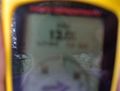
I got to within the range of accuracy of the GPS.
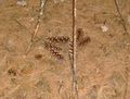
... and marked the spot with pinecones
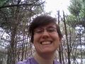
... and took a picture of my stupid mid-jog grin.
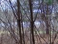
... and the view towards the reservoir.


... and then I jogged back to the car. Jogging back wasn't fun, but I'm glad to have made it to the hashpoint.
On the way back I saw a pair of ducks and a few Canada Geese, and since there were no humans within earshot, I told the geese in English and French to get back home.
I slowed down a little towards the end, and then while driving to the school I got lost due to a detour, so I was late picking up the children, but they and the school survived.
Ribbon
Ever since I saw that Yerushalmi had invented this ribbon, I wanted to claim it too, but I had to wait until Passover. No food is allowed on the path at the reservoir, so I achieved this ribbon as soon as I got back to the car.
Sara earned the Unleavened Geohash achievement
|