Difference between revisions of "2010-04-10 42 -72"
imported>Sara (expand subst:expedition) |
imported>Sara (It's great to see the children enjoying throwing rocks into a brook, instead of playing video games.) |
||
| Line 1: | Line 1: | ||
| − | + | [[Image:{{{image|2010-04-10_42_-72_towards_river.jpg}}}|thumb|left]] | |
| − | |||
| − | |||
| − | [[Image:{{{image| | ||
| − | |||
| − | |||
| − | |||
{{meetup graticule | {{meetup graticule | ||
| lat=42 | | lat=42 | ||
| Line 11: | Line 5: | ||
| date=2010-04-10 | | date=2010-04-10 | ||
}} | }} | ||
| − | |||
| − | |||
__NOTOC__ | __NOTOC__ | ||
== Location == | == Location == | ||
| − | + | ||
| + | In the trees behind some houses in West Springfield, Massachusetts. | ||
== Participants == | == Participants == | ||
| − | |||
| − | + | [[User:Sara|Sara and her children]] | |
| − | + | ||
== Expedition == | == Expedition == | ||
| − | |||
| − | + | We drove over there, and discovered a lemonade stand - the archetype of discovering something fun and unexpected only because one went geohashing. | |
| − | + | ||
| + | Sipping our lemondade, we took a slightly longer route to the hashpoint than was strictly necessary, because the direct route would have required cutting through someone's yard, and anyway we enjoy tromping through the woods. The hashpoint was very close to the highway, but you can't really see the highway from there and you can hardly hear it. | ||
| + | |||
| + | After we found the hashpoint, my daughter decided we should walk down to a nearby brook. I really enjoyed seeing my children get interested in throwing rocks into the brook, because we end up spending so much time inside. | ||
| + | |||
== Photos == | == Photos == | ||
| Line 34: | Line 29: | ||
--> | --> | ||
<gallery perrow="4"> | <gallery perrow="4"> | ||
| + | Image:2010-04-10_42_-72_lemonade.jpg | Some kids were running a lemonade stand right near where we parked, so we partook. | ||
| + | Image:2010-04-10_42_-72_gps.jpg | The GPS. | ||
| + | Image:2010-04-10_42_-72_both_in_tree.jpg | The kids named this their "favorite climbing tree". It was a few meters from the hashpoint. | ||
| + | Image:2010-04-10_42_-72_s_in_tree.jpg | My daughter took this picture of her brother. | ||
| + | Image:2010-04-10_42_-72_towards_river.jpg | Schoolhouse Brook was just down the hill from the hashpoint. My daughter decided to go down there and take some pictures. | ||
| + | Image:2010-04-10_42_-72_d_at_river.jpg | The children enjoyed spending ten or fifteen minutes throwing rocks into the brook. | ||
</gallery> | </gallery> | ||
| − | |||
| − | |||
| − | |||
| − | |||
| − | |||
| − | |||
| − | |||
| − | |||
| − | |||
| − | |||
[[Category:Expeditions]] | [[Category:Expeditions]] | ||
| − | |||
[[Category:Expeditions with photos]] | [[Category:Expeditions with photos]] | ||
| − | |||
| − | |||
| − | |||
| − | |||
| − | |||
[[Category:Coordinates reached]] | [[Category:Coordinates reached]] | ||
| − | |||
| − | |||
| − | |||
| − | |||
| − | |||
| − | |||
| − | |||
| − | |||
| − | |||
| − | |||
Revision as of 01:39, 11 April 2010

| Sat 10 Apr 2010 in 42,-72: 42.1513277, -72.6384178 geohashing.info google osm bing/os kml crox |
Location
In the trees behind some houses in West Springfield, Massachusetts.
Participants
Expedition
We drove over there, and discovered a lemonade stand - the archetype of discovering something fun and unexpected only because one went geohashing.
Sipping our lemondade, we took a slightly longer route to the hashpoint than was strictly necessary, because the direct route would have required cutting through someone's yard, and anyway we enjoy tromping through the woods. The hashpoint was very close to the highway, but you can't really see the highway from there and you can hardly hear it.
After we found the hashpoint, my daughter decided we should walk down to a nearby brook. I really enjoyed seeing my children get interested in throwing rocks into the brook, because we end up spending so much time inside.
Photos
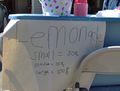
Some kids were running a lemonade stand right near where we parked, so we partook.
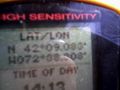
The GPS.
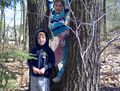
The kids named this their "favorite climbing tree". It was a few meters from the hashpoint.
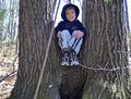
My daughter took this picture of her brother.
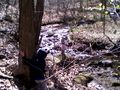
Schoolhouse Brook was just down the hill from the hashpoint. My daughter decided to go down there and take some pictures.
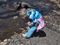
The children enjoyed spending ten or fifteen minutes throwing rocks into the brook.


