Difference between revisions of "2010-04-28 55 13"
imported>Fasanen (→Plans) |
imported>Llavids |
||
| Line 9: | Line 9: | ||
In the forest a few kilometers west from [[wikipedia:Häckeberga_Castle|Häckeberga Castle]], [[wikipedia:Skåne|Skåne]], [[wikipedia:Sweden|Sweden]]. | In the forest a few kilometers west from [[wikipedia:Häckeberga_Castle|Häckeberga Castle]], [[wikipedia:Skåne|Skåne]], [[wikipedia:Sweden|Sweden]]. | ||
| − | == | + | == [[User:Llavids|Llavids]] == |
| − | [[User: | ||
| − | == Plans == | + | === Plans === |
| + | To get there first, since this will render me a FTF on a geocache on [http://opencaching.se opencaching.se]. | ||
| + | |||
| + | === Expedition === | ||
| + | Drove there early in the day and arrived there about 9.30. Found the place to be easily accessible as it seemed to be on satellite photo. Documented the place and returned to work. Found out later that day that [[User:Fasanen|Fasanen]] had the same idea but I got there first. | ||
| + | |||
| + | === Photos === | ||
| + | |||
| + | <gallery perrow="3"> | ||
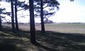
| + | Image:2010-04-28-Sweden-Stitched.jpg|Stitched photo of the surroundings. | ||
| + | </gallery> | ||
| + | |||
| + | == [[User:Fasanen|Fasanen]] == | ||
| + | |||
| + | === Plans === | ||
I learnt about geohashing a few weeks ago through a virtual cache on [http://opencaching.se opencaching.se] and have since then been following the hashpoint coordinates. Either I have been too busy or the coordinates have been located in the sea or in fields with growing crops but today I had some time to spare and the location seemed nice. | I learnt about geohashing a few weeks ago through a virtual cache on [http://opencaching.se opencaching.se] and have since then been following the hashpoint coordinates. Either I have been too busy or the coordinates have been located in the sea or in fields with growing crops but today I had some time to spare and the location seemed nice. | ||
| − | == Expedition == | + | === Expedition === |
Weather was fantastic. I drove the car to the hashpoint which was very easily accessed as it was located just 10-15 meters from the road in a friendly open forest close to a grassy field. After documenting the place I went to find a [[wikipedia:geocache|geocache]] which was located just half a kilometer down the road. | Weather was fantastic. I drove the car to the hashpoint which was very easily accessed as it was located just 10-15 meters from the road in a friendly open forest close to a grassy field. After documenting the place I went to find a [[wikipedia:geocache|geocache]] which was located just half a kilometer down the road. | ||
| − | == Photos == | + | === Photos === |
<gallery perrow="3"> | <gallery perrow="3"> | ||
Revision as of 14:06, 1 October 2010
| Wed 28 Apr 2010 in 55,13: 55.5789415, 13.3715768 geohashing.info google osm bing/os kml crox |
Location
In the forest a few kilometers west from Häckeberga Castle, Skåne, Sweden.
Llavids
Plans
To get there first, since this will render me a FTF on a geocache on opencaching.se.
Expedition
Drove there early in the day and arrived there about 9.30. Found the place to be easily accessible as it seemed to be on satellite photo. Documented the place and returned to work. Found out later that day that Fasanen had the same idea but I got there first.
Photos

Stitched photo of the surroundings.
Fasanen
Plans
I learnt about geohashing a few weeks ago through a virtual cache on opencaching.se and have since then been following the hashpoint coordinates. Either I have been too busy or the coordinates have been located in the sea or in fields with growing crops but today I had some time to spare and the location seemed nice.
Expedition
Weather was fantastic. I drove the car to the hashpoint which was very easily accessed as it was located just 10-15 meters from the road in a friendly open forest close to a grassy field. After documenting the place I went to find a geocache which was located just half a kilometer down the road.
Photos
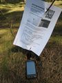
Geohash flyer with navigation device
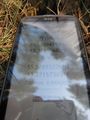
Coordinates reached
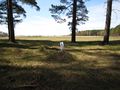
The location

Me
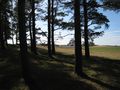
View from the location
Crap quality HTC image but contains GPS data in EXIF


