Difference between revisions of "2010-05-01 47 -122"
imported>OtherJack (→Photos) |
imported>OtherJack (→Photos) |
||
| Line 40: | Line 40: | ||
--> | --> | ||
<gallery perrow="4"> | <gallery perrow="4"> | ||
| − | Image:2010-05-01 47 -122 IMG 2758. | + | Image:2010-05-01 47 -122 IMG 2758.JPG | Nice view of the bay from the hashpoint, with new-looking houses... |
| − | Image:2010-05-01 47 -122 IMG 2761. | + | Image:2010-05-01 47 -122 IMG 2761.JPG | ... just like the one that will probably be built on this spot soon enough. |
| − | Image:2010-05-01 47 -122 IMG 2762. | + | Image:2010-05-01 47 -122 IMG 2762.JPG | Trees lookin' good. |
</gallery> | </gallery> | ||
Revision as of 20:50, 2 May 2010
| Sat 1 May 2010 in 47,-122: 47.2938299, -122.6122118 geohashing.info google osm bing/os kml crox |
Location
On the shore of Wollochet bay near Gig Harbor.
Participants
Plans
There were plans, but some events delayed arrival at the hashpoint
Expedition
OtherJack
Due to a sequence of bizarre and unanticipated events, I did not make it to the hashpoint (47 deg 17.630' N, 122 deg 36.733' W) until well past 4:30pm... hope I didn't miss anyone who came on time! It was worth the drive though... on a conveniently vacant lot, right at the shore of Wollochet Bay near Gig Harbor. Big trees, new housing development on the other side of the bay, tide flats, etc. Plus, this led me to make my first ever crossings of the Tacoma Narrows Bridge, site of every physics teacher's favorite man-made disaster! (Galloping Gertie)
Photos
Photo(s) will be posted soon.
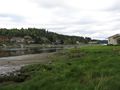
Nice view of the bay from the hashpoint, with new-looking houses...
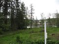
... just like the one that will probably be built on this spot soon enough.
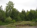
Trees lookin' good.


