Difference between revisions of "2010-05-19 53 -113"
From Geohashing
imported>B cereus (→Photos) |
m |
||
| (4 intermediate revisions by 3 users not shown) | |||
| Line 17: | Line 17: | ||
== Participants == | == Participants == | ||
| − | B cereus | + | [[User:B cereus|B cereus]] |
== Plans == | == Plans == | ||
| Line 28: | Line 28: | ||
== Photos == | == Photos == | ||
<gallery perrow="4"> | <gallery perrow="4"> | ||
| − | Image:2010-05-19 53 -113 01.jpg | | + | Image:2010-05-19 53 -113 01.jpg | Sign from the road south of the hash |
| − | Image:2010-05-19 53 -113 02.jpg | | + | Image:2010-05-19 53 -113 02.jpg | Sign from the road west of the hash |
</gallery> | </gallery> | ||
| Line 38: | Line 38: | ||
| date = 2010-05-19 | | date = 2010-05-19 | ||
| name = B cereus | | name = B cereus | ||
| − | | image = 2010-05-19 53 - | + | | image = 2010-05-19 53 -113 01.jpg |
}} | }} | ||
| Line 44: | Line 44: | ||
[[Category:Coordinates reached]] | [[Category:Coordinates reached]] | ||
[[Category:Expeditions with photos]] | [[Category:Expeditions with photos]] | ||
| + | {{location|CA|AB|LD}} | ||
Latest revision as of 19:38, 18 March 2022
| Wed 19 May 2010 in 53,-113: 53.3715929, -113.5080525 geohashing.info google osm bing/os kml crox |
Location
In a field just north of Nisku.
Participants
Plans
On my way back to Edmonton from work, I'll try to hit as many hash points as possible.
Expedition
Thought this would be another easy hash, just off the main highway near my work. Sadly I was thwarted by No Trespassing signs on both roads near the hash. So that's a total of 2/4 for my trip back from work.
Photos
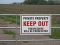
Sign from the road south of the hash
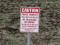
Sign from the road west of the hash


Ribbons
B cereus earned the No trespassing consolation prize
|