Difference between revisions of "2010-05-21 48 11"
imported>The T-Man (→Achievements) |
imported>DerFlob (→Photos) |
||
| Line 40: | Line 40: | ||
Image:2009-##-## ## ## Alpha.jpg | Witty Comment | Image:2009-##-## ## ## Alpha.jpg | Witty Comment | ||
--> | --> | ||
| − | <gallery perrow="5"> | + | <gallery perrow="5" caption="DerFlob"> |
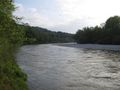
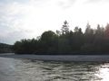
| + | Image:2010-05-21_48_11_Flob_01.jpg | Looking down on the [http://en.wikipedia.org/wiki/Isar Isar] from the Gründwalder bridge | ||
| + | Image:2010-05-21_48_11_Flob_02_marked.jpg |A map of the area. The hashpoint is marked with a red circle. The location of the map is covered by the rivet. | ||
| + | Image:2010-05-21_48_11_Flob_03.jpg | | ||
| + | Image:2010-05-21_48_11_Flob_04.jpg | Looking down on a hydropower plant. | ||
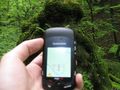
| + | Image:2010-05-21_48_11_Flob_05.jpg | According to my GPS, the hashpoint was located on the upper right at the stone. | ||
| + | Image:2010-05-21_48_11_Flob_06.jpg | Proof. Sorry for the blurry picture... | ||
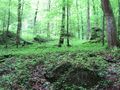
| + | Image:2010-05-21_48_11_Flob_07.jpg | The hashstone. The hashpoint was located exactly on this stone. | ||
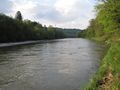
| + | Image:2010-05-21_48_11_Flob_08.jpg | Isar. Upstream. | ||
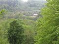
| + | Image:2010-05-21_48_11_Flob_09.jpg | Behind these trees is the power plant. | ||
| + | Image:2010-05-21_48_11_Flob_10.jpg | Isar. Downstream, going towards Munich. | ||
| + | Image:2010-05-21_48_11_Flob_11.jpg | A snail that crossed my path and nearly ran into me ;) | ||
| + | Image:2010-05-21_48_11_Flob_12.jpg | | ||
</gallery> | </gallery> | ||
Revision as of 16:42, 24 May 2010
| Fri 21 May 2010 in 48,11: 48.0229115, 11.4999128 geohashing.info google osm bing/os kml crox |
Location
In a forest alongside the Isar river, south of Grünwald near München
Participants
Plans
After finishing the written part of my Abitur tomorrow, I'm glad to go geohashing again. Don't know yet when exactly I'll show up, but I guess around 4 p.m.? --DerFlob 21:01, 20 May 2010 (UTC)
- The weather today isn't that nice, but I'll visit the hash anyway at about 6 p.m. :) --DerFlob 06:03, 21 May 2010 (UTC)
Expedition
The_T-Man's expedition
The_T-Man took a suburban train to Rosenheimer Platz in downtown München, from where on he got to Grünwald by taking the tram line 25. The hashpoint, which was about 2,7 km away from the tram station, was located in a forest, but fairly easily accessible because there were a lot of small paths. To get to the exact (or, as it turned out later, rather approximate) location, he had to go about 30 m up a hillside next to the path until his GPS reciever told him that he had reached the place. After taking a small break and leaving a message for potential followers, The_T-Man got on his way back home again, having enjoyed the silence of the forest and the fact that (after about 2 weeks of bad weather) there had been no rain during his expedition.
Tracklog
Photos
- DerFlob
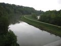
Looking down on the Isar from the Gründwalder bridge
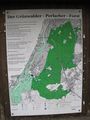
A map of the area. The hashpoint is marked with a red circle. The location of the map is covered by the rivet.
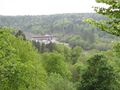
Looking down on a hydropower plant.
According to my GPS, the hashpoint was located on the upper right at the stone.
Proof. Sorry for the blurry picture...
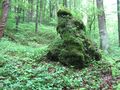
The hashstone. The hashpoint was located exactly on this stone.
Isar. Upstream.
Behind these trees is the power plant.
Isar. Downstream, going towards Munich.
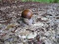
A snail that crossed my path and nearly ran into me ;)


Achievements
DerFlob and The_T-Man earned the 2010 Geohashing Day achievement
|