Difference between revisions of "2010-05-21 50 10"
imported>Jiml m (Fill in) |
imported>Danatar |
||
| Line 1: | Line 1: | ||
| − | + | {{meetup graticule | |
| − | |||
| − | |||
| − | |||
| − | |||
| − | |||
| − | |||
| − | |||
| − | |||
| − | {{meetup graticule | ||
| lat=50 | | lat=50 | ||
| lon=10 | | lon=10 | ||
| date=2010-05-21 | | date=2010-05-21 | ||
| − | }} | + | | graticule_name=Schweinfurt |
| − | + | | graticule_link=Schweinfurt, Germany | |
| − | + | }}__NOTOC__ | |
| − | __NOTOC__ | ||
== Location == | == Location == | ||
| − | |||
| − | |||
| − | |||
| − | |||
| − | |||
| − | + | Today's location is in a field near Haßfurt. | |
| − | |||
| − | + | Country: Germany; state: Bayern (Bavaria, EU:DE:BY); administrative region: Unterfranken; district: Haßberge | |
| − | |||
| − | == | + | == Expedition== |
| − | + | ===[[User:Danatar|Danatar]]=== | |
| + | Geohashing Day! It was very important to visit a hashpoint today, so I chose the nearest one. When driving to Schweinfurt for work, I stayed on the Autobahn A70, which I left at the exit "Haßfurt". A short route over country roads later I stopped near the hashpoint. When I got out of the car, the battery in both my GPS units were dead. I switched the around a bit and one of the units worked again. I walked along the road to the correct field, one of the passing cars honked at me although I was walking in the grass on the road shoulder. When I saw that the strange plants growing on the field had enough space between them to walk, I went up to the hashpoint. I didn't do any great celebration and left no marker, because I was already getting late, so I just took a few pictures, walked back to the car and went to work. There I arrived 4 minutes late. | ||
| − | |||
| − | |||
| − | |||
| − | |||
| − | |||
| − | |||
| − | == | + | {{Geohashing Day | latitude = 50 | longitude = 10| year = 2010 | coorddate = 2010-05-21 | name = Danatar | image = 2010-05-21 50 10 hp.jpg}} |
| − | |||
| − | |||
| − | < | + | <gallery> |
| − | + | Image:2010-05-21 50 10 near.jpg|the hashfield | |
| − | + | Image:2010-05-21 50 10 field.jpg|What is this? | |
| − | + | Image:2010-05-21 50 10 gps.jpg|still working for another 5 minutes | |
| + | Image:2010-05-21 50 10 hp.jpg|Geohashing Day coordinates reached! | ||
| + | </gallery> | ||
[[Category:Expeditions]] | [[Category:Expeditions]] | ||
| − | |||
| − | |||
[[Category:Expeditions with photos]] | [[Category:Expeditions with photos]] | ||
| − | |||
| − | |||
| − | |||
| − | |||
| − | |||
[[Category:Coordinates reached]] | [[Category:Coordinates reached]] | ||
| − | + | [[Category:Danatar]] | |
| − | |||
| − | |||
| − | |||
| − | |||
| − | |||
| − | |||
| − | |||
| − | [[Category: | ||
| − | |||
Revision as of 09:25, 22 May 2010
| Fri 21 May 2010 in Schweinfurt: 50.0229115, 10.4999128 geohashing.info google osm bing/os kml crox |
Location
Today's location is in a field near Haßfurt.
Country: Germany; state: Bayern (Bavaria, EU:DE:BY); administrative region: Unterfranken; district: Haßberge
Expedition
Danatar
Geohashing Day! It was very important to visit a hashpoint today, so I chose the nearest one. When driving to Schweinfurt for work, I stayed on the Autobahn A70, which I left at the exit "Haßfurt". A short route over country roads later I stopped near the hashpoint. When I got out of the car, the battery in both my GPS units were dead. I switched the around a bit and one of the units worked again. I walked along the road to the correct field, one of the passing cars honked at me although I was walking in the grass on the road shoulder. When I saw that the strange plants growing on the field had enough space between them to walk, I went up to the hashpoint. I didn't do any great celebration and left no marker, because I was already getting late, so I just took a few pictures, walked back to the car and went to work. There I arrived 4 minutes late.
Danatar earned the 2010 Geohashing Day achievement
|
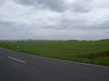
the hashfield
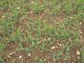
What is this?
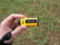
still working for another 5 minutes
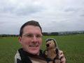
Geohashing Day coordinates reached!


