Difference between revisions of "2010-05-22 53 9"
imported>Masi (→Participants) |
imported>FippeBot m (Location) |
||
| (10 intermediate revisions by 2 users not shown) | |||
| Line 1: | Line 1: | ||
| − | |||
<!-- If you did not specify these parameters in the template, please substitute appropriate things for IMAGE, LAT, LON, and DATE (YYYY-MM-DD format) | <!-- If you did not specify these parameters in the template, please substitute appropriate things for IMAGE, LAT, LON, and DATE (YYYY-MM-DD format) | ||
| Line 12: | Line 11: | ||
}} | }} | ||
| − | + | ||
__NOTOC__ | __NOTOC__ | ||
== Location == | == Location == | ||
| − | |||
The hash was in a field, that could be reached without trespassing. There were even some trees for the "The Internet was here" sign and picnicking in the shadows. | The hash was in a field, that could be reached without trespassing. There were even some trees for the "The Internet was here" sign and picnicking in the shadows. | ||
== Participants == | == Participants == | ||
| − | + | * [[User:Masi|Masi]] - His first geohash, achieved | |
| − | [[Masi]] - His first geohash, achieved | + | * Masi's cycling friend |
| + | * Masi's driving friend | ||
| + | |||
== Plans == | == Plans == | ||
| − | + | [[User:Masi|Masi]] planned to go by bicycle and eventually even get the Tron achievement. But his bike had a flat | |
| + | tire and he had to go with public transportation. | ||
== Expedition == | == Expedition == | ||
| − | + | ||
| + | [[User:Masi|Masi]] met with a friend who rode by bicycle at train station Neu Wulmstorf. They had to go another path a bit more to the west, because the Google Maps path wasn't actually there. | ||
| + | |||
| + | Just when they reached the geohash a cyclist drove by, waved and drove towards them. It was friend of theirs! | ||
| + | |||
| + | The three had a picnic and playing session. | ||
== Tracklog == | == Tracklog == | ||
| − | + | ||
| + | [[User:Masi|Masi]]'s travel route. For privacy reasons limited: http://de.wikiloc.com/wikiloc/view.do?id=921609 | ||
== Photos == | == Photos == | ||
| − | + | ||
| − | |||
| − | |||
<gallery perrow="5"> | <gallery perrow="5"> | ||
| + | Image:2010_05_22_53_9_cards.JPG|Playing the game President. Everybody won once. | ||
| + | Image:2010_05_22_53_9_gpsproof.jpg|[[User:Masi|Masi]]'s little Holux M-241. | ||
| + | Image:2010_05_22_53_9_masi.JPG|[[User:Masi|Masi]] | ||
| + | Image:2010_05_22_53_9_picnicandgames.JPG|Butter cake, dice, card and black tea. | ||
| + | Image:2010_05_22_53_9_theinternetwashere.JPG|xkcd comic 659 | ||
</gallery> | </gallery> | ||
== Achievements == | == Achievements == | ||
{{#vardefine:ribbonwidth|800px}} | {{#vardefine:ribbonwidth|800px}} | ||
| − | |||
| + | {{land geohash | ||
| + | | latitude = 53 | ||
| + | | longitude = 9 | ||
| + | | date = 2010-05-22 | ||
| + | | name = Masi | ||
| + | |||
| + | }} | ||
| + | |||
| + | {{Public transport geohash | ||
| + | | latitude = 53 | ||
| + | | longitude = 9 | ||
| + | | date = 2010-05-22 | ||
| + | | busline = S3 from Hauptbahnhof to Neu Wulmstorf | ||
| + | | name = Masi | ||
| + | |||
| + | }} | ||
| − | |||
| − | |||
| − | |||
| − | |||
| − | |||
| − | |||
| − | |||
| − | |||
[[Category:Expeditions]] | [[Category:Expeditions]] | ||
| − | |||
[[Category:Expeditions with photos]] | [[Category:Expeditions with photos]] | ||
| − | |||
| − | |||
| − | |||
| − | |||
[[Category:Coordinates reached]] | [[Category:Coordinates reached]] | ||
| − | + | {{location|DE|NI|STD}} | |
| − | |||
| − | |||
| − | |||
| − | |||
| − | |||
| − | |||
| − | |||
| − | |||
| − | |||
Latest revision as of 02:08, 9 August 2019
| Sat 22 May 2010 in 53,9: 53.4635260, 9.7646015 geohashing.info google osm bing/os kml crox |
Location
The hash was in a field, that could be reached without trespassing. There were even some trees for the "The Internet was here" sign and picnicking in the shadows.
Participants
- Masi - His first geohash, achieved
- Masi's cycling friend
- Masi's driving friend
Plans
Masi planned to go by bicycle and eventually even get the Tron achievement. But his bike had a flat tire and he had to go with public transportation.
Expedition
Masi met with a friend who rode by bicycle at train station Neu Wulmstorf. They had to go another path a bit more to the west, because the Google Maps path wasn't actually there.
Just when they reached the geohash a cyclist drove by, waved and drove towards them. It was friend of theirs!
The three had a picnic and playing session.
Tracklog
Masi's travel route. For privacy reasons limited: http://de.wikiloc.com/wikiloc/view.do?id=921609
Photos
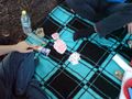
Playing the game President. Everybody won once.
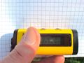
Masi's little Holux M-241.
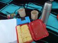
Butter cake, dice, card and black tea.
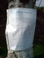
xkcd comic 659


Achievements
Masi earned the Land geohash achievement
|
Masi earned the Public transport geohash achievement
|