Difference between revisions of "2010-06-11 39 -92"
imported>PhysicsNerds (Created page with '<!-- If you did not specify these parameters in the template, please substitute appropriate things for IMAGE, LAT, LON, and DATE (YYYY-MM-DD format) [[Image:{{{image|IMAGE}}}|t…') |
m (per Renaming Proposal) |
||
| (5 intermediate revisions by 4 users not shown) | |||
| Line 1: | Line 1: | ||
| − | |||
| − | |||
| − | |||
| − | |||
| − | |||
| − | |||
{{meetup graticule | {{meetup graticule | ||
| − | | lat= | + | | lat=39 |
| − | | lon=- | + | | lon=-92 |
| date=2010-06-11 | | date=2010-06-11 | ||
}} | }} | ||
| − | + | ||
__NOTOC__ | __NOTOC__ | ||
== Location == | == Location == | ||
| − | + | [[Moberly, Missouri |BFE, Missouri]] | |
| − | BFE, Missouri | ||
== Participants == | == Participants == | ||
| − | + | ||
| − | Patrick and Sara ([[PhysicsNerds]]) | + | Patrick and Sara ([[User:PhysicsNerds|PhysicsNerds]]) |
== Plans == | == Plans == | ||
| − | |||
We had a few hours to kill before baking, and the hash today happened to be within reach. | We had a few hours to kill before baking, and the hash today happened to be within reach. | ||
== Expedition == | == Expedition == | ||
| − | |||
We began by loading up on soda at QT, as we knew that it would be our last chance before leaving civilization to venture into BFE. We had an hour and a half drive ahead of us (according to Google Maps) and a short walk off of the road. Or, so we thought. | We began by loading up on soda at QT, as we knew that it would be our last chance before leaving civilization to venture into BFE. We had an hour and a half drive ahead of us (according to Google Maps) and a short walk off of the road. Or, so we thought. | ||
| Line 33: | Line 24: | ||
We couldn't manage to get the GPS to display the last decimal places correctly, but we reached the hash and managed a pair of achievements! | We couldn't manage to get the GPS to display the last decimal places correctly, but we reached the hash and managed a pair of achievements! | ||
| − | |||
| − | |||
== Photos == | == Photos == | ||
| − | + | ||
| − | + | <gallery perrow="3"> | |
| − | |||
| − | <gallery perrow=" | ||
Image:DSC02797.jpg | There was supposed to be a third sign pointing toward us. I guess it was as lost as we were. | Image:DSC02797.jpg | There was supposed to be a third sign pointing toward us. I guess it was as lost as we were. | ||
Image:DSC02800.jpg | Found it! Not a particularly helpful place for it to be... | Image:DSC02800.jpg | Found it! Not a particularly helpful place for it to be... | ||
| Line 51: | Line 38: | ||
== Achievements == | == Achievements == | ||
{{#vardefine:ribbonwidth|800px}} | {{#vardefine:ribbonwidth|800px}} | ||
| − | |||
| − | |||
{{land geohash | {{land geohash | ||
| Line 64: | Line 49: | ||
}} | }} | ||
| − | {{ | + | {{Graticule unlocked |
| latitude = 39 | | latitude = 39 | ||
| Line 75: | Line 60: | ||
| − | |||
| − | |||
| − | |||
| − | |||
| − | |||
| − | |||
| − | |||
[[Category:Expeditions]] | [[Category:Expeditions]] | ||
| − | + | ||
[[Category:Expeditions with photos]] | [[Category:Expeditions with photos]] | ||
| − | + | ||
| − | |||
| − | |||
| − | |||
[[Category:Coordinates reached]] | [[Category:Coordinates reached]] | ||
| − | + | {{location|US|MO|HR}} | |
Latest revision as of 06:12, 20 March 2024
| Fri 11 Jun 2010 in 39,-92: 39.3019754, -92.8102425 geohashing.info google osm bing/os kml crox |
Location
Participants
Patrick and Sara (PhysicsNerds)
Plans
We had a few hours to kill before baking, and the hash today happened to be within reach.
Expedition
We began by loading up on soda at QT, as we knew that it would be our last chance before leaving civilization to venture into BFE. We had an hour and a half drive ahead of us (according to Google Maps) and a short walk off of the road. Or, so we thought.
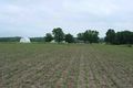
Our first setback came with the realization that many of the streets were poorly labeled, if at all. However, after three hours, many U-turns and hunting for cellular signal to get directions, we found our way to Co Rd 431. The hash was within sight, but on private property. Being respectful, we trekked to the nearest house in seek of permission to trespass. Despite obvious signs that someone was home, they refused to answer the door. Taking their lack of concern as permission, we trudged through the mud- carefully avoiding the rows of crops- halfway into the field and right to the hash.
We couldn't manage to get the GPS to display the last decimal places correctly, but we reached the hash and managed a pair of achievements!
Photos
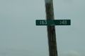
There was supposed to be a third sign pointing toward us. I guess it was as lost as we were.
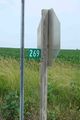
Found it! Not a particularly helpful place for it to be...
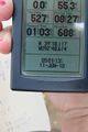
We made it!

Yay!
Hopefully they didn't mind us trespassing.
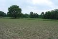
Luckily, it was close to the car and we didn't have to trudge through too much mud.


Achievements
Sara and Patrick earned the Land geohash achievement
|
Sara and Patrick earned the Graticule Unlocked Achievement
|