Difference between revisions of "2010-06-22 52 5"
From Geohashing
imported>Antior |
imported>Antior |
||
| Line 36: | Line 36: | ||
{{#vardefine:ribbonwidth|800px}} | {{#vardefine:ribbonwidth|800px}} | ||
<!-- Add any achievement ribbons you earned below, or remove this section --> | <!-- Add any achievement ribbons you earned below, or remove this section --> | ||
| + | {{land geohash | ||
| + | | latitude = 52 | ||
| + | | longitude = 5 | ||
| + | | date = 2010-06-22 | ||
| + | | name = Antior and Freeze_XJ | ||
| + | |||
| + | }} | ||
| + | |||
| + | {{Tron | ||
| + | | latitude = 52 | ||
| + | | longitude = 5 | ||
| + | | date = 2010-06-22 | ||
| + | | tracklog = http://wiki.xkcd.com/geohashing/2010-06-22_52_5 | ||
| + | | possessive = his | ||
| + | | name = Antior | ||
| + | |||
| + | }} | ||
| + | |||
[[Category:Expeditions]] | [[Category:Expeditions]] | ||
[[Category:Expeditions with photos]] | [[Category:Expeditions with photos]] | ||
[[Category:Expedition without GPS]] | [[Category:Expedition without GPS]] | ||
[[Category:Coordinates reached]] | [[Category:Coordinates reached]] | ||
Revision as of 18:37, 22 June 2010

| Tue 22 Jun 2010 in 52,5: 52.0604751, 5.1870988 geohashing.info google osm bing/os kml crox |
Location
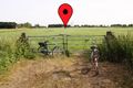
In a piece of farmland just south of a highway near Bunnik
Participants
Plans
We'll go there by bike after dinner. A Tron hash might be possible for Antior. We don't have a GPS device available so we'll have to do that the old way.
Expedition
Geohash reached. Full report will be written later. Simply said : jump on your bike, decide that you really should turn left here, hop over the fence (no farmer in sight!) and walk there. Life was easy. Freeze_XJ screwed his Tron-attempt early on, but since Antior tried to make it, the ride back was a little longer. Bunnik is really a nice town, i think :P
Photos

Turn back ... Turn back ... Oh nooooo
Wow, did you see that?
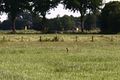
The killer rabbit was faster
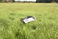
Really, there's nothing to see here


Achievements
Antior and Freeze_XJ earned the Land geohash achievement
|
Antior earned the Tron achievement
|