Difference between revisions of "2010-06-26 43 -79"
From Geohashing
imported>Splitdipless (Created page with '{{subst:Expedition |lat = 43 |lon = -79 |date = 2010-06-26 }}') |
imported>Splitdipless |
||
| Line 1: | Line 1: | ||
| − | |||
| − | |||
| − | |||
| − | |||
| − | |||
| − | |||
| − | |||
| − | |||
| − | |||
| − | |||
{{meetup graticule | {{meetup graticule | ||
| lat=43 | | lat=43 | ||
| Line 18: | Line 8: | ||
__NOTOC__ | __NOTOC__ | ||
== Location == | == Location == | ||
| − | + | Lake Ontario, so I didn't go there. | |
| + | |||
| + | Went to 43.56178, -79.66268 (now called Mississauga) and 43.56178, -79.76268 (now called Snider) instead. Both of which ended up in school yards. How odd. | ||
== Participants == | == Participants == | ||
| − | + | [[User:Splitdipless|Splitdipless]] | |
| − | == Plans == | + | <!-- == Plans == --> |
| − | |||
== Expedition == | == Expedition == | ||
| − | |||
| − | == | + | === [[User:Splitdipless|Splitdipless]] === |
| − | + | ||
| + | So, as the point was out in Lake Ontario, I decided to try and do two Decihashes instead. I chose two decihashes right next to each other that share a strange co-incidence at the decihash points: they both ended up in school yards. | ||
| + | <!-- == Tracklog == --> | ||
== Photos == | == Photos == | ||
<!-- Insert pictures between the gallery tags using the following format: | <!-- Insert pictures between the gallery tags using the following format: | ||
Image:2010-##-## ## ## Alpha.jpg | Witty Comment | Image:2010-##-## ## ## Alpha.jpg | Witty Comment | ||
--> | --> | ||
| + | === [[User:Splitdipless|Splitdipless]] === | ||
| + | ==== Mississauga Decicule ==== | ||
<gallery perrow="5"> | <gallery perrow="5"> | ||
| + | Image:2010-06-26 43 -79 0.7 D1A.jpg | I'm there. | ||
| + | Image:2010-06-26 43 -79 0.7 D1B.jpg | Without stupid grin. | ||
| + | Image:2010-06-26 43 -79 0.7 D1C.jpg | That's better. | ||
| + | </gallery> | ||
| + | |||
| + | ==== Snider Decicule ==== | ||
| + | <gallery perrow="5"> | ||
| + | Image:2010-06-26 43 -79 0.7 D1A.jpg | I'm there. | ||
| + | Image:2010-06-26 43 -79 0.7 D1B.jpg | Without stupid grin. | ||
| + | Image:2010-06-26 43 -79 0.7 D1C.jpg | That's better. | ||
</gallery> | </gallery> | ||
== Achievements == | == Achievements == | ||
{{#vardefine:ribbonwidth|800px}} | {{#vardefine:ribbonwidth|800px}} | ||
| − | + | === [[User:Splitdipless|Splitdipless]] === | |
| − | + | None. Didn't even attempt regular geohash point. | |
| − | |||
| − | |||
| − | |||
| − | |||
| − | |||
| − | |||
| − | |||
| − | |||
| − | |||
[[Category:Expeditions]] | [[Category:Expeditions]] | ||
| − | |||
[[Category:Expeditions with photos]] | [[Category:Expeditions with photos]] | ||
| − | |||
| − | |||
| − | |||
| − | |||
| − | |||
| − | |||
| − | |||
| − | |||
| − | |||
[[Category:Coordinates not reached]] | [[Category:Coordinates not reached]] | ||
| − | |||
| − | |||
| − | |||
| − | |||
[[Category:Not reached - Did not attempt]] | [[Category:Not reached - Did not attempt]] | ||
| − | |||
Revision as of 05:30, 3 September 2010
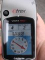
| Sat 26 Jun 2010 in 43,-79: 43.5617815, -79.2626874 geohashing.info google osm bing/os kml crox |
Location
Lake Ontario, so I didn't go there.
Went to 43.56178, -79.66268 (now called Mississauga) and 43.56178, -79.76268 (now called Snider) instead. Both of which ended up in school yards. How odd.
Participants
Expedition
Splitdipless
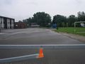
So, as the point was out in Lake Ontario, I decided to try and do two Decihashes instead. I chose two decihashes right next to each other that share a strange co-incidence at the decihash points: they both ended up in school yards.
Photos
Splitdipless
Mississauga Decicule
I'm there.
Without stupid grin.
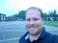
That's better.


Snider Decicule
I'm there.
Without stupid grin.
That's better.
Achievements
Splitdipless
None. Didn't even attempt regular geohash point.