Difference between revisions of "2010-06-28 39 -86"
imported>ErWenn (coordinates reached by ErWenn) |
m (→Plans: external links) |
||
| (2 intermediate revisions by 2 users not shown) | |||
| Line 21: | Line 21: | ||
== Plans == | == Plans == | ||
| − | [[User:ErWenn|Erik]] announced his intention to hash to the local geocaching groups ( | + | |
| + | [[User:ErWenn|Erik]] announced his intention to hash to the local geocaching groups ([http://groups.google.com/group/bloomingtongeocaching Bloomington Geocachers] and the IU [https://indiana.edu/~geocache Geocaching Club]). He got a response from a fellow geocacher who was planning on biking right by the spot on his way to Lake Monroe. They weren't able to meet up, but Erik has been assured that the hash was reached that afternoon at 4ish. Hopefully he'll stop by to log his visit. | ||
== Expedition == | == Expedition == | ||
| Line 41: | Line 42: | ||
| − | + | {{land_geohash | |
| − | + | | latitude = 39 | |
| − | [[ | + | | longitude = -86 |
| + | | date = 2010-06-28 | ||
| + | | name = [[User:ErWenn|Erik]] | ||
| + | }} | ||
| + | |||
| − | |||
| Line 51: | Line 55: | ||
[[Category:Expeditions with photos]] | [[Category:Expeditions with photos]] | ||
[[Category:Coordinates reached]] | [[Category:Coordinates reached]] | ||
| − | + | {{location|US|IN|MR}} | |
| − | |||
| − | |||
| − | |||
| − | |||
| − | |||
| − | |||
| − | |||
| − | |||
| − | |||
Latest revision as of 03:08, 23 February 2022
| Mon 28 Jun 2010 in 39,-86: 39.0740816, -86.5052913 geohashing.info google osm bing/os kml crox |
Location
In Smithville, about three miles south of Bloomington, a few feet off Fairfax Rd.
Participants
Erik showed up late in the evening (around 10:30pm).
Plans
Erik announced his intention to hash to the local geocaching groups (Bloomington Geocachers and the IU Geocaching Club). He got a response from a fellow geocacher who was planning on biking right by the spot on his way to Lake Monroe. They weren't able to meet up, but Erik has been assured that the hash was reached that afternoon at 4ish. Hopefully he'll stop by to log his visit.
Expedition
Erik
I started pretty late, but I figured it would be an easy grab. I drove just past the hash, parked in a convenience store, and walked a few hundred feet back to the spot. It was late, but there were several porch parties going on in the neighborhood, so I didn't look that bizarre. I didn't even have to get off the shoulder to get to the coordinates. My real camera's batteries were dead, so I was stuck with my crappy phone camera. Sadly, none of my efforts to get myself photographed (eerily lit by a flashlight, of course) panned out, but at least I got a readable picture of the GPSr display for proof.
Photos
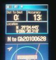
Proof that Erik made it.

Achievements
Erik earned the Land geohash achievement
|