Difference between revisions of "2010-07-04 45 -123"
From Geohashing
imported>Jiml m (Fill in first draft) |
imported>FippeBot m (Location) |
||
| (2 intermediate revisions by one other user not shown) | |||
| Line 27: | Line 27: | ||
== Photos == | == Photos == | ||
| − | + | ||
| − | + | ||
| − | |||
<gallery perrow="5"> | <gallery perrow="5"> | ||
| + | Image:2010-07-04_45_-123-pond.jpg | The pond that appears to contain the hashpoint | ||
| + | Image:2010-07-04_45_-123-sign.jpg | A clear indication to leave it alone | ||
| + | |||
</gallery> | </gallery> | ||
| Line 36: | Line 38: | ||
{{#vardefine:ribbonwidth|800px}} | {{#vardefine:ribbonwidth|800px}} | ||
<!-- Add any achievement ribbons you earned below, or remove this section --> | <!-- Add any achievement ribbons you earned below, or remove this section --> | ||
| + | |||
| + | |||
| + | {{No trespassing | ||
| + | | latitude = 45 | ||
| + | | longitude = -123 | ||
| + | | date =2010-07-04 | ||
| + | | name = Jim | ||
| + | }} | ||
| Line 46: | Line 56: | ||
[[Category:Not reached - Mother Nature]] | [[Category:Not reached - Mother Nature]] | ||
[[Category:Not reached - No public access]] | [[Category:Not reached - No public access]] | ||
| + | {{location|US|OR|YA}} | ||
Latest revision as of 02:38, 9 August 2019
| Sun 4 Jul 2010 in 45,-123: 45.2742172, -123.0983293 geohashing.info google osm bing/os kml crox |
Location
A pond near Carlton, Oregon
Participants
Plans
I decided I'd try to go by if I was up to it after I was done with my picnic in Claskanie.
Expedition
A pond on private property on the side of the road.
Photos
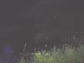
The pond that appears to contain the hashpoint
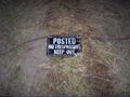
A clear indication to leave it alone


Achievements
Jim earned the No trespassing consolation prize
|