Difference between revisions of "2010-07-04 54 10"
imported>Pne m |
imported>Pne (description) |
||
| Line 9: | Line 9: | ||
__NOTOC__ | __NOTOC__ | ||
== Location == | == Location == | ||
| − | + | In a field not far from a road in Kiel-Meimersdorf. | |
== Participants == | == Participants == | ||
| Line 15: | Line 15: | ||
== Plans == | == Plans == | ||
| − | + | This is not my home graticule, but I was going to visit family there - and saw that the geohash was very close to where I would be that morning! So I thought I'd try to make it. I also wanted to try to get my family to come along. | |
== Expedition == | == Expedition == | ||
| − | + | Drove to the road closest to the geohash. Tried to convince the others to come along as well, but they all refused, so I set off alone. | |
| + | |||
| + | I followed by satnav's directions, but going south down the road turned out not to be useful: there was a hedge between it and the field all the short way I went, so I turned back to where I had seen an opening. I took a picture of the field from there. | ||
| + | |||
| + | From there, it was easy: the field was covered with short grass and was easy to walk over - no fences, ditches, thorns, or other nastiness. | ||
| + | |||
| + | After a short walk, I was able to correct my course to walk directly towards the hashpoint; then I did the "GPS dance" to try to get my satnav to display the exact coordinates. | ||
| + | |||
| + | When I got it exact (to the five decimal places that my satnav showed), I wanted to take a picture - but the camera's battery was so low that it turned itself off before I could take a picture. Bummer :( But at least I have a tracklog to show that I was there. (And since my family didn't come along, I didn't need a picture of them to prove the Drag-Along achievement or whatever it's called.) | ||
== Tracklog == | == Tracklog == | ||
Revision as of 19:26, 4 July 2010

| Sun 4 Jul 2010 in 54,10: 54.2742172, 10.0983293 geohashing.info google osm bing/os kml crox |
Location
In a field not far from a road in Kiel-Meimersdorf.
Participants
Plans
This is not my home graticule, but I was going to visit family there - and saw that the geohash was very close to where I would be that morning! So I thought I'd try to make it. I also wanted to try to get my family to come along.
Expedition
Drove to the road closest to the geohash. Tried to convince the others to come along as well, but they all refused, so I set off alone.
I followed by satnav's directions, but going south down the road turned out not to be useful: there was a hedge between it and the field all the short way I went, so I turned back to where I had seen an opening. I took a picture of the field from there.
From there, it was easy: the field was covered with short grass and was easy to walk over - no fences, ditches, thorns, or other nastiness.
After a short walk, I was able to correct my course to walk directly towards the hashpoint; then I did the "GPS dance" to try to get my satnav to display the exact coordinates.
When I got it exact (to the five decimal places that my satnav showed), I wanted to take a picture - but the camera's battery was so low that it turned itself off before I could take a picture. Bummer :( But at least I have a tracklog to show that I was there. (And since my family didn't come along, I didn't need a picture of them to prove the Drag-Along achievement or whatever it's called.)
Tracklog
Tracklog at http://pne.mizinamo.org/geohashing/Tracklog_2010-07-04_54_10.gpx .
Photos
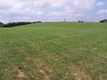
The field where the hashpoint lay