Difference between revisions of "2010-07-14 50 8"
imported>Pne (start page) |
imported>FippeBot m (Location) |
||
| (3 intermediate revisions by one other user not shown) | |||
| Line 1: | Line 1: | ||
| − | |||
| − | |||
| − | |||
| − | |||
| − | |||
| − | |||
| − | |||
{{meetup graticule | {{meetup graticule | ||
| lat=50 | | lat=50 | ||
| lon=8 | | lon=8 | ||
| date=2010-07-14 | | date=2010-07-14 | ||
| + | | graticule_name=Frankfurt am Main, Germany | ||
}} | }} | ||
| Line 15: | Line 9: | ||
__NOTOC__ | __NOTOC__ | ||
== Location == | == Location == | ||
| − | + | Right in the middle of a road in Frankfurt-Riedberg. | |
| + | |||
| + | Fortunately, the road had two lanes in each direction and a green strip in the middle... and the hashpoint was ''exactly'' in the middle of the road, so on the green strip. | ||
| + | |||
| + | I wasn't quite sure whether the green strip was to be walked on, but close to the hashpoint, there was evidence of people crossing the road at that place (from one side, over the green strip, to the otherside), so I used that place to cross onto the green strip and walk the last couple of metres to the hashpoint. | ||
== Participants == | == Participants == | ||
| − | + | *[[User:Pne|Pne]] | |
== Plans == | == Plans == | ||
| − | + | I was on holiday in the Frankfurt area for a week. Since I would be without Internet there, I had arranged for coordinates to be sent to my phone by SMS every day. | |
| + | |||
| + | I had planned to travel around on Wednesday 2010-07-14 to visit two other places, so I was going to purchase a day ticket anyway. Imagine my surprise when I found that the coordinates for that day were inside Frankfurt, easily reachable by public transport and not all that far off from the route I was going to take anyway! | ||
== Expedition == | == Expedition == | ||
| − | + | I called 01805-RMV-INFO to ask how to get to the location, since I had no Internet. They told me which bus stop was closest, which busses stop there, and where to take them from. | |
| + | |||
| + | So I stopped at Hauptwache, took the U1 to Nordwestzentrum, and then the 26 bus to Lurgiallee. | ||
| − | + | The bus drove alone Marie-Curie-Allee, the road containing the hashpoint. | |
| − | |||
| − | + | I walked back a little and found the place. I had picked up a stone along the way which I thought I might use to mark the position, like with chalk. | |
| − | |||
| − | |||
| − | |||
| − | |||
| − | |||
| − | + | There was a tree there, so I tried to write "xkcd" on it; unfortunately, the stone was harder than I had thought and it scratched the bark rather than chalking on the outside. Sorry, tree. | |
| − | |||
| − | |||
| + | Then back to the bus stop; this time, I continued on with the 26 to Heddernheim, from where I took the U-Bahn again to Frankfurt Süd, and continued on my route. | ||
| − | + | == Tracklog == | |
| − | + | Unfortunately, my tracklog has entries for the morning and the afternoon, but not around noon when I was there :( Perhaps a software reset deleted it or something. | |
| − | |||
| − | < | + | == Photos == |
| − | + | <gallery perrow="3"> | |
| − | + | Image:2010-07-14 50 8 satnav.jpg | Satnav showing coordinates reached | |
| − | --> | + | Image:2010-07-14 50 8 tree.jpg | A tree just northeast of the hashpoint - also lets you see the position of the hashpoint in the middle of the road |
| + | Image:2010-07-14 50 8 stupid grin.jpg | Obligatory stupid grin | ||
| + | </gallery> | ||
| − | |||
[[Category:Expeditions]] | [[Category:Expeditions]] | ||
| − | |||
[[Category:Expeditions with photos]] | [[Category:Expeditions with photos]] | ||
| − | |||
| − | |||
| − | |||
| − | |||
| − | |||
[[Category:Coordinates reached]] | [[Category:Coordinates reached]] | ||
| − | + | {{location|DE|HE|F}} | |
| − | |||
| − | |||
| − | |||
| − | |||
| − | |||
| − | |||
| − | |||
| − | |||
| − | |||
Latest revision as of 02:47, 9 August 2019
| Wed 14 Jul 2010 in Frankfurt am Main, Germany: 50.1695828, 8.6342099 geohashing.info google osm bing/os kml crox |
Location
Right in the middle of a road in Frankfurt-Riedberg.
Fortunately, the road had two lanes in each direction and a green strip in the middle... and the hashpoint was exactly in the middle of the road, so on the green strip.
I wasn't quite sure whether the green strip was to be walked on, but close to the hashpoint, there was evidence of people crossing the road at that place (from one side, over the green strip, to the otherside), so I used that place to cross onto the green strip and walk the last couple of metres to the hashpoint.
Participants
Plans
I was on holiday in the Frankfurt area for a week. Since I would be without Internet there, I had arranged for coordinates to be sent to my phone by SMS every day.
I had planned to travel around on Wednesday 2010-07-14 to visit two other places, so I was going to purchase a day ticket anyway. Imagine my surprise when I found that the coordinates for that day were inside Frankfurt, easily reachable by public transport and not all that far off from the route I was going to take anyway!
Expedition
I called 01805-RMV-INFO to ask how to get to the location, since I had no Internet. They told me which bus stop was closest, which busses stop there, and where to take them from.
So I stopped at Hauptwache, took the U1 to Nordwestzentrum, and then the 26 bus to Lurgiallee.
The bus drove alone Marie-Curie-Allee, the road containing the hashpoint.
I walked back a little and found the place. I had picked up a stone along the way which I thought I might use to mark the position, like with chalk.
There was a tree there, so I tried to write "xkcd" on it; unfortunately, the stone was harder than I had thought and it scratched the bark rather than chalking on the outside. Sorry, tree.
Then back to the bus stop; this time, I continued on with the 26 to Heddernheim, from where I took the U-Bahn again to Frankfurt Süd, and continued on my route.
Tracklog
Unfortunately, my tracklog has entries for the morning and the afternoon, but not around noon when I was there :( Perhaps a software reset deleted it or something.
Photos
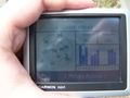
Satnav showing coordinates reached
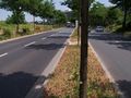
A tree just northeast of the hashpoint - also lets you see the position of the hashpoint in the middle of the road

Obligatory stupid grin


