Difference between revisions of "2010-07-17 36 -86"
From Geohashing
imported>Benjw (+success cats) |
imported>Jiml m (Adjust result codes, Tweak headings and formatting) |
||
| Line 11: | Line 11: | ||
}} | }} | ||
| − | |||
__NOTOC__ | __NOTOC__ | ||
== Location == | == Location == | ||
| − | |||
Middle of an empty field. | Middle of an empty field. | ||
== Participants == | == Participants == | ||
| − | + | * Andrew Tiller | |
| − | Andrew Tiller | + | * Reed Jones |
| + | * Taylor Jones | ||
== Plans == | == Plans == | ||
| − | |||
"LET'S DO THIS" -Reed Jones | "LET'S DO THIS" -Reed Jones | ||
| Line 28: | Line 26: | ||
<!-- how it all turned out. your narrative goes here. --> | <!-- how it all turned out. your narrative goes here. --> | ||
| + | <!-- Nothing here for now > | ||
== Tracklog == | == Tracklog == | ||
<!-- if your GPS device keeps a log, you may post a link here --> | <!-- if your GPS device keeps a log, you may post a link here --> | ||
== Photos == | == Photos == | ||
| − | + | <gallery perrow="3"> | |
| − | |||
| − | |||
| − | <gallery perrow=" | ||
Image:2010-07-17_36_-86_17-38-35-379.jpg | From left to right: Andrew Tiller, Reed Jones, and Taylor Jones [http://www.openstreetmap.org/?lat=36.5689&lon=-86.5352&zoom=16&layers=B000FTF @36.5689,-86.5352] | Image:2010-07-17_36_-86_17-38-35-379.jpg | From left to right: Andrew Tiller, Reed Jones, and Taylor Jones [http://www.openstreetmap.org/?lat=36.5689&lon=-86.5352&zoom=16&layers=B000FTF @36.5689,-86.5352] | ||
| Line 52: | Line 48: | ||
== Achievements == | == Achievements == | ||
{{#vardefine:ribbonwidth|800px}} | {{#vardefine:ribbonwidth|800px}} | ||
| − | |||
{{land geohash | {{land geohash | ||
| Line 63: | Line 58: | ||
}} | }} | ||
| − | |||
| − | |||
| − | |||
| − | |||
| − | |||
| − | |||
| − | |||
| − | |||
[[Category:Expeditions]] | [[Category:Expeditions]] | ||
| − | |||
[[Category:Expeditions with photos]] | [[Category:Expeditions with photos]] | ||
| − | + | ||
| − | |||
| − | |||
| − | |||
[[Category:Coordinates reached]] | [[Category:Coordinates reached]] | ||
| − | |||
| − | |||
| − | |||
| − | |||
| − | |||
| − | |||
| − | |||
| − | |||
| − | |||
Revision as of 23:58, 24 July 2010
| Sat 17 Jul 2010 in 36,-86: 36.5687441, -86.5352076 geohashing.info google osm bing/os kml crox |
Location
Middle of an empty field.
Participants
- Andrew Tiller
- Reed Jones
- Taylor Jones
Plans
"LET'S DO THIS" -Reed Jones
Expedition
Photos
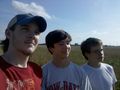
From left to right: Andrew Tiller, Reed Jones, and Taylor Jones @36.5689,-86.5352
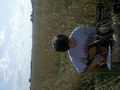
Reed rehearses. @36.5687,-86.5352
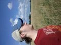
Taylor @36.5687,-86.5352
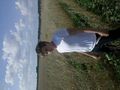
Tiller takes in the sights @36.5688,-86.5352


Videos
Achievements
Andrew Tiller, Reed Jones, and Taylor Jones earned the Land geohash achievement
|