Difference between revisions of "2010-07-17 48 -123"
imported>Wenslayer (Write-up) |
m (More specific location) |
||
| (5 intermediate revisions by 2 users not shown) | |||
| Line 29: | Line 29: | ||
Wow, what a view! A nice sunny day, and a feeling of accomplishment as I made it to the summit. I snapped a few pics, fueled up, and then continued down the other side for a kilometre to the familiar gate I saw in the Google Street View. | Wow, what a view! A nice sunny day, and a feeling of accomplishment as I made it to the summit. I snapped a few pics, fueled up, and then continued down the other side for a kilometre to the familiar gate I saw in the Google Street View. | ||
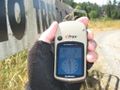
| − | Now the gate was open when I got there, but the no trespassing sign on it was still clearly visible. It's too bad, since my GPS reported it 81m away from the gate. I could have easily walked in to the coordinates, snapped a pic and left with none the wiser. However, I respected the sign and simply snapped a few more pics. | + | Now the gate was open when I got there, but the no trespassing sign on it was still clearly visible. It's too bad, since my GPS reported it a mere 81m away from the gate. I could have easily walked in to the coordinates, snapped a pic and left with none the wiser. However, I respected the sign and simply snapped a few more pics. |
| + | |||
| + | I crossed the highway and began my ride home. The ride down the Malahat was a lot of fun, although somewhat frustrating due to a significant head-wind that restricted my top speed to only 60km/h (my friend reports it's easy to reach 80km/h down a particular stretch). The rest of the ride home was pleasant but uneventful. | ||
| + | |||
| + | Despite not reaching the Geohash coordinates, I felt a sense of accomplishment having summited the Malahat for the first time. In addition, I knew [[2010-07-18 48 -123|tomorrow's Geohash]] was doable and closer! | ||
== Tracklog == | == Tracklog == | ||
| − | [ | + | Tracklog is available in KML form [http://xqnstyl.fea.st/kml/2010-07-17%2048%20-123%20Geohash.kml here]. |
== Photos == | == Photos == | ||
| − | + | <gallery perrow="4"> | |
| − | + | Image:2010-07-17 48 -123 Malahat view.jpg | View from the Malahat summit, and how I got here | |
| − | <gallery perrow=" | + | Image:2010-07-17 48 -123 Malahat totem.jpg | A cool totem pole at the Malahat summit |
| + | Image:2010-07-17 48 -123 Malahat Wenslayer.jpg | [[User:Wenslayer|Yours truly]] | ||
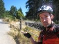
| + | Image:2010-07-17 48 -123 Malahat sign.jpg | How high I climbed | ||
| + | Image:2010-07-17 48 -123 ahead.jpg | Geohash point straight ahead | ||
| + | Image:2010-07-17 48 -123 soclose.jpg | Just how close (with sign behind) | ||
| + | Image:2010-07-17 48 -123 sosad.jpg | No trespassing makes [[User:Wenslayer|Wenslayer]] sad. | ||
</gallery> | </gallery> | ||
== Achievements == | == Achievements == | ||
| − | {{#vardefine:ribbonwidth| | + | {{#vardefine:ribbonwidth|600px}} |
| − | + | {{:User:Wenslayer/Achievement No Trespassing}} | |
| − | |||
[[Category:Expeditions]] | [[Category:Expeditions]] | ||
[[Category:Expeditions with photos]] | [[Category:Expeditions with photos]] | ||
| − | |||
[[Category:Coordinates not reached]] | [[Category:Coordinates not reached]] | ||
[[Category:Not reached - No public access]] | [[Category:Not reached - No public access]] | ||
| + | {{location|CA|BC|CV}} | ||
Latest revision as of 23:27, 9 August 2020
| Sat 17 Jul 2010 in 48,-123: 48.5687441, -123.5352076 geohashing.info google osm bing/os kml crox |
Location
Very close to the Malahat summit, just off the highway. Looking at the Google Street View, it looks like it's a no-trespassing area.
Participants
Plans
I planned to simply bike out there, as part of one of my big weekly rides, and see if I might gain admittance to the property -- who knows, maybe the owner will be there (and be willing to let me in)?
Expedition
I took my time getting up in the morning, enjoying breakfast while Google-mapping the route and location. I packed up, and hit the road just before 10am. I knew I was in for a big climb, so I took it easy getting to the bottom of the Malahat. I made a quick pit-stop at Goldstream Park and then began my ascent.
I've driven this route before and thought it was quite a climb, and now I was experiencing it on my bike. The first part was a real grind, with the road twisting and narrow (down to less than a metre of shoulder on this highway). The road straightened out, and the grade eased off, but it was still uphill. A few parts leveled off and even dipped a bit, but then before the summit, the grade increased and I ground out the last couple of kilometres to the top.
Wow, what a view! A nice sunny day, and a feeling of accomplishment as I made it to the summit. I snapped a few pics, fueled up, and then continued down the other side for a kilometre to the familiar gate I saw in the Google Street View.
Now the gate was open when I got there, but the no trespassing sign on it was still clearly visible. It's too bad, since my GPS reported it a mere 81m away from the gate. I could have easily walked in to the coordinates, snapped a pic and left with none the wiser. However, I respected the sign and simply snapped a few more pics.
I crossed the highway and began my ride home. The ride down the Malahat was a lot of fun, although somewhat frustrating due to a significant head-wind that restricted my top speed to only 60km/h (my friend reports it's easy to reach 80km/h down a particular stretch). The rest of the ride home was pleasant but uneventful.
Despite not reaching the Geohash coordinates, I felt a sense of accomplishment having summited the Malahat for the first time. In addition, I knew tomorrow's Geohash was doable and closer!
Tracklog
Tracklog is available in KML form here.
Photos
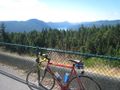
View from the Malahat summit, and how I got here
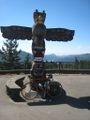
A cool totem pole at the Malahat summit
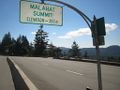
How high I climbed
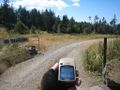
Geohash point straight ahead
Just how close (with sign behind)
No trespassing makes Wenslayer sad.


Achievements
Wenslayer earned the No trespassing consolation prize
|