Difference between revisions of "2010-07-22 51 -0"
imported>Davidc (New expedition) |
imported>FippeBot m (Location) |
||
| (4 intermediate revisions by one other user not shown) | |||
| Line 1: | Line 1: | ||
| − | |||
| − | |||
| − | |||
| − | |||
| − | |||
| − | |||
| − | |||
| − | |||
| − | |||
| − | |||
{{meetup graticule | {{meetup graticule | ||
| − | | lat= | + | | lat=51 |
| lon=-0 | | lon=-0 | ||
| date=2010-07-22 | | date=2010-07-22 | ||
}} | }} | ||
| − | |||
__NOTOC__ | __NOTOC__ | ||
== Location == | == Location == | ||
| − | + | In a field by a fishery and caravan park near Newdigate, Surrey. | |
== Participants == | == Participants == | ||
| − | + | * [[User:Davidc|davidc]] | |
== Plans == | == Plans == | ||
| − | + | Noticing in the morning that the coordinates were only ~10km away by bike, I cursed the intermittent heavy rain showers and severe weather warning. It wasn't until 16:00 when it had been dry for a few hours that I dared to set off. | |
== Expedition == | == Expedition == | ||
| − | + | I've enthused before about the marvellous system of public rights of way in the UK - the legal framework and the huge network of footpaths, bridleways and byways that make it possible to go pretty much anywhere you like in the countryside, even across private land. As usual, there was a footpath within a short distance of this hash, and I was able to travel most of the way there without having to use roads. | |
| + | |||
| + | The lake is home to a fishery, a catch and release fishing lake, an adjacent caravan park, and apparently a paintball range as well. The fishing clubhouse had a well stocked bar and was just visible through the treeline from the hash point and I indulged in an icy-cold cider after hashing. | ||
| + | |||
| + | Bicycles are theoretically not allowed on public footpaths (only on bridleways with the horses), and it would usually be tough work anyway as they have frequent stiles. I ended up approaching the hash not from the footpath but from the private road leading to the lake. This led me to the corner of the hash field, and a simple trip down and up the bordering ditch brought me into the wheat field. From here, it was simply a question of finding a path to the hash point causing the least amount of crop damage. The satellite image was not helpful as it showed last year's tracks, but the GPS reception was good out in the open and the hash was quickly logged. | ||
| + | |||
| + | Coordinates were reached around 17:15. A lovely cider in the sunshine was my reward followed by the slog home and the vicious final climb up the hill to where I'm staying. | ||
== Tracklog == | == Tracklog == | ||
| − | + | http://maps.google.com/?t=p&z=15&ll=51.24578857421875,-0.25269800424575806&q=http://api.motionxlive.com/motionx-remote/api/gps/host/6907fdf4-c028-4204-b156-8ecc739a952a | |
| − | == Photos == | + | == Photos == |
| − | |||
| − | |||
| − | |||
<gallery perrow="5"> | <gallery perrow="5"> | ||
| + | File:2010-07-22_51_-0_IMG_2267.JPG|Fishing lake. | ||
| + | File:2010-07-22_51_-0_IMG_2268.JPG|Fishing lake. | ||
| + | File:2010-07-22_51_-0_IMG_2269.JPG|Clubhouse. | ||
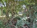
| + | File:2010-07-22_51_-0_IMG_2270.JPG|Hash field on left across ditch. | ||
| + | File:2010-07-22_51_-0_IMG_2271.JPG|View into hash field. | ||
| + | File:2010-07-22_51_-0_IMG_2273.JPG|Corny. | ||
| + | File:2010-07-22_51_-0_IMG_2275.JPG|Hash field. | ||
| + | File:2010-07-22_51_-0_IMG_0003.PNG|iPhone map proof. | ||
| + | File:2010-07-22_51_-0_IMG_0005.PNG|iPhone GPS proof. | ||
| + | File:2010-07-22_51_-0_IMG_2281.JPG|Perplexed. | ||
| + | File:2010-07-22_51_-0_IMG_2288.JPG|Where's rabbitfox? | ||
| + | File:2010-07-22_51_-0_IMG_2284.JPG|There she is! | ||
| + | File:2010-07-22_51_-0_IMG_2289.JPG|Clubhouse just visible through trees. | ||
| + | File:2010-07-22_51_-0_IMG_2291.JPG|Closer shot for proof. | ||
| + | File:2010-07-22_51_-0_IMG_2292.JPG|Horses. | ||
| + | File:2010-07-22_51_-0_IMG_2293.JPG|Horse. | ||
</gallery> | </gallery> | ||
== Achievements == | == Achievements == | ||
{{#vardefine:ribbonwidth|800px}} | {{#vardefine:ribbonwidth|800px}} | ||
| − | + | {{Minesweeper geohash | graticule = 50,-0 | ranknumber = 5 | s = true | nw = true | n = true | se = true | e = true | name = [[User:Davidc|davidc]]}} | |
| + | {{pub geohash | latitude=51 | longitude=-0 | date=2010-07-22 | name=[[User:Davidc|davidc]]}} | ||
| − | |||
| − | |||
| − | |||
| − | |||
| − | |||
| − | |||
| − | |||
| − | |||
| − | |||
| − | |||
| − | |||
[[Category:Expeditions]] | [[Category:Expeditions]] | ||
| − | |||
[[Category:Expeditions with photos]] | [[Category:Expeditions with photos]] | ||
| − | |||
| − | |||
| − | |||
| − | |||
| − | |||
[[Category:Coordinates reached]] | [[Category:Coordinates reached]] | ||
| − | + | {{location|GB|ENG|SRY}} | |
| − | |||
| − | |||
| − | |||
| − | |||
| − | |||
| − | |||
| − | |||
| − | |||
| − | |||
Latest revision as of 02:55, 9 August 2019
| Thu 22 Jul 2010 in 51,-0: 51.1832738, -0.3001400 geohashing.info google osm bing/os kml crox |
Location
In a field by a fishery and caravan park near Newdigate, Surrey.
Participants
Plans
Noticing in the morning that the coordinates were only ~10km away by bike, I cursed the intermittent heavy rain showers and severe weather warning. It wasn't until 16:00 when it had been dry for a few hours that I dared to set off.
Expedition
I've enthused before about the marvellous system of public rights of way in the UK - the legal framework and the huge network of footpaths, bridleways and byways that make it possible to go pretty much anywhere you like in the countryside, even across private land. As usual, there was a footpath within a short distance of this hash, and I was able to travel most of the way there without having to use roads.
The lake is home to a fishery, a catch and release fishing lake, an adjacent caravan park, and apparently a paintball range as well. The fishing clubhouse had a well stocked bar and was just visible through the treeline from the hash point and I indulged in an icy-cold cider after hashing.
Bicycles are theoretically not allowed on public footpaths (only on bridleways with the horses), and it would usually be tough work anyway as they have frequent stiles. I ended up approaching the hash not from the footpath but from the private road leading to the lake. This led me to the corner of the hash field, and a simple trip down and up the bordering ditch brought me into the wheat field. From here, it was simply a question of finding a path to the hash point causing the least amount of crop damage. The satellite image was not helpful as it showed last year's tracks, but the GPS reception was good out in the open and the hash was quickly logged.
Coordinates were reached around 17:15. A lovely cider in the sunshine was my reward followed by the slog home and the vicious final climb up the hill to where I'm staying.
Tracklog
Photos
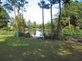
Fishing lake.
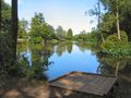
Fishing lake.
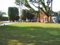
Clubhouse.
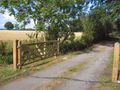
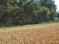
Hash field on left across ditch.
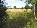
View into hash field.
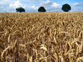
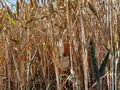
Corny.
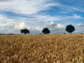
Hash field.
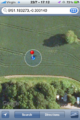
iPhone map proof.
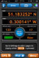
iPhone GPS proof.

Perplexed.
Where's rabbitfox?
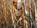
There she is!
Clubhouse just visible through trees.
Closer shot for proof.
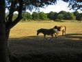
Horses.
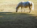
Horse.


Achievements
davidc achieved level 5 of the Minesweeper Geohash achievement
|
davidc earned the Pub Geohash Achievement
|