Difference between revisions of "2010-07-23 -37 145"
imported>Stevage (Created page with '{{subst:Expedition |lat = -37 |lon = 145 |date = 2010-07-23 }}') |
imported>Stevage (write up) |
||
| Line 1: | Line 1: | ||
| − | |||
<!-- If you did not specify these parameters in the template, please substitute appropriate things for IMAGE, LAT, LON, and DATE (YYYY-MM-DD format) | <!-- If you did not specify these parameters in the template, please substitute appropriate things for IMAGE, LAT, LON, and DATE (YYYY-MM-DD format) | ||
| Line 18: | Line 17: | ||
__NOTOC__ | __NOTOC__ | ||
== Location == | == Location == | ||
| − | + | Near a reservoir on the outskirts of [[wikipedia:Broadford, Victoria|Broadford, Victoria]]. | |
== Participants == | == Participants == | ||
| − | + | [[User:Stevage|Stevage]], Mitchell, and Ben. Tim C slept through it in the car. | |
| + | |||
| + | == Expedition == | ||
| + | Seven of us were on our way to Falls Creek for a cross-country ski-touring weekend. Naturally I checked for any geohashes on the way. Broadford was really convenient, being just off the Hume. But before an expedition could be launched, I needed to convince one car-load of people. | ||
| + | |||
| + | One by one people entered the clubrooms and failed to be convinced by my and Tim's persuasive arguments. Finally there was one person left, Ben, the driver of the second car. "By the way, we need to make a quick detour along the way" | ||
| + | "It's more like 'want to' than 'need'", quickly interjected someone who will remain nameless. | ||
| + | "We need to get to a completely random point tonight!" I persisted. | ||
| + | "Sounds great, I'm in!" replied Ben, and we were off. | ||
| − | + | An hour or two later, we were in Broadford, and heading down Reservoir Rd. Surprisingly, when I offered everyone the choice of the "adventurous way" (down a back road and scrambling over the train tracks) or the "straightforward way", everyone opted for the latter. We parked in front of two closed gates. On the right, "Timmar Kennels". On the left, an unlabelled gate. From the air, I had expected some sort of park, water catchment, or public land, but it was far from clear whether this was private or public. | |
| − | |||
| − | + | In the dark (my geohashes are invariably nocturnal), we hopped over the fence, and set off down a dirt track that was little more than the repeated imprints of four wheel drive tyres. As expected, it led virtually all the way to the geohash, through open country with just a couple of trees and brambles for interest. Although we tried to keep our voices down, it wasn't long before the kennels next door were excited. Nothing like the buzz of agitated barking to add a bit of atmosphere to an otherwise quiet stroll in the dark. | |
| − | |||
== Tracklog == | == Tracklog == | ||
| Line 33: | Line 38: | ||
== Photos == | == Photos == | ||
| − | |||
| − | |||
| − | |||
<gallery perrow="5"> | <gallery perrow="5"> | ||
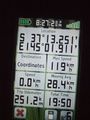
| + | File:2010-07-23 -37 145 gps.jpg | Success. | ||
</gallery> | </gallery> | ||
| Line 43: | Line 46: | ||
<!-- Add any achievement ribbons you earned below, or remove this section --> | <!-- Add any achievement ribbons you earned below, or remove this section --> | ||
| + | [[Category:Expeditions]] | ||
| − | |||
| − | |||
| − | |||
| − | |||
| − | |||
| − | |||
| − | |||
| − | |||
| − | |||
| − | |||
| − | |||
| − | |||
[[Category:Expeditions with photos]] | [[Category:Expeditions with photos]] | ||
| − | |||
| − | |||
| − | |||
| − | |||
| − | |||
[[Category:Coordinates reached]] | [[Category:Coordinates reached]] | ||
| − | |||
| − | |||
| − | |||
| − | |||
| − | |||
| − | |||
| − | |||
| − | |||
| − | |||
| − | |||
Revision as of 01:17, 28 July 2010
| Fri 23 Jul 2010 in -37,145: -37.2208321, 145.0318562 geohashing.info google osm bing/os kml crox |
Location
Near a reservoir on the outskirts of Broadford, Victoria.
Participants
Stevage, Mitchell, and Ben. Tim C slept through it in the car.
Expedition
Seven of us were on our way to Falls Creek for a cross-country ski-touring weekend. Naturally I checked for any geohashes on the way. Broadford was really convenient, being just off the Hume. But before an expedition could be launched, I needed to convince one car-load of people.
One by one people entered the clubrooms and failed to be convinced by my and Tim's persuasive arguments. Finally there was one person left, Ben, the driver of the second car. "By the way, we need to make a quick detour along the way" "It's more like 'want to' than 'need'", quickly interjected someone who will remain nameless. "We need to get to a completely random point tonight!" I persisted. "Sounds great, I'm in!" replied Ben, and we were off.
An hour or two later, we were in Broadford, and heading down Reservoir Rd. Surprisingly, when I offered everyone the choice of the "adventurous way" (down a back road and scrambling over the train tracks) or the "straightforward way", everyone opted for the latter. We parked in front of two closed gates. On the right, "Timmar Kennels". On the left, an unlabelled gate. From the air, I had expected some sort of park, water catchment, or public land, but it was far from clear whether this was private or public.
In the dark (my geohashes are invariably nocturnal), we hopped over the fence, and set off down a dirt track that was little more than the repeated imprints of four wheel drive tyres. As expected, it led virtually all the way to the geohash, through open country with just a couple of trees and brambles for interest. Although we tried to keep our voices down, it wasn't long before the kennels next door were excited. Nothing like the buzz of agitated barking to add a bit of atmosphere to an otherwise quiet stroll in the dark.
Tracklog
Photos
Success.
