2010-07-24 38 -92
| Sat 24 Jul 2010 in Columbia: 38.6328885, -92.4948978 geohashing.info google osm bing/os kml crox |
Location
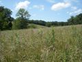
Random field east of California, Missouri
Participants
Expedition
This time I decided to go geohashing with another friend, Isaac. We left Jefferson City west on 50 with him driving and me giving directions. We lost our way several times due to street names being different from those on Google Maps, but eventually we found our way down several gravel roads to the property near the hash. Fortunately, the nearby house was abandoned and the field showed no signs of development; combined with the absence of any "No Trespassing" signs, we took this as permission to explore.
We had to pass under a pair of barbed wire fences and through a significant amount of waist-high weeds, but eventually we reached the location as nearly as we could determine, given that I still have not come into possession of a GPS. We snapped a few pictures of ourselves and some nearby landmarks for proof, then returned home, stopping only to get drinks at a country market at which we spotted a man in a Slipknot shirt and black cargo pants looking very out of place (unfortunately, no pictures of that).
Photos
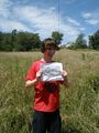
Me at the geohash, holding our Google Maps reference sheet
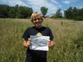
Isaac holding the same at the hash
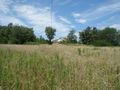
View of the house from the field
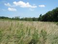
View of the field from the field
More field
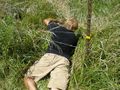
Creative solution
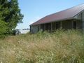
View of the house and shed seen on Google Maps
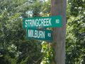
Streets for proof
Many drinks were had


