2010-07-25 38 -110
From Geohashing
Revision as of 04:21, 28 July 2010 by imported>Redaragorn (→Location)
| Sun 25 Jul 2010 in 38,-110: 38.5182129, -110.6414956 geohashing.info google osm bing/os kml crox |
Location
I was visiting family up in Utah for the long weekend, and looked ahead to find that the hash wasn't far off highway 24 in southern Utah. We were planning on taking our time getting home, so I figured it would be fun to motor through that (very scenic) area on our way back. The particular location looked very close to the highway, but I was a little bit worried about finding a suitable place to pull off the road and attempt to get there. I was also assuming that there would be a fence, and it was always possible (although unlikely) that it would be located on private land and have a Posted sign. At any rate, it looked very doable so we took the chance.
Participants
Plans
Expedition
Track
Track located here.
Pictures
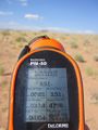
GPS coordinates

Me grinning
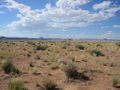
A look around


