Difference between revisions of "2010-07-31 58 12"
From Geohashing
imported>Klibbnisse (Created page with '{{subst:Expedition |lat = 58 |lon = 12 |date = 2010-07-31 }}') |
imported>FippeBot m (Location) |
||
| (2 intermediate revisions by one other user not shown) | |||
| Line 1: | Line 1: | ||
| − | |||
| − | |||
| − | |||
| − | |||
| − | |||
| − | |||
| − | |||
| − | |||
| − | |||
| − | |||
{{meetup graticule | {{meetup graticule | ||
| lat=58 | | lat=58 | ||
| Line 15: | Line 5: | ||
}} | }} | ||
| − | |||
__NOTOC__ | __NOTOC__ | ||
== Location == | == Location == | ||
| − | + | East of Nygård, near something that seems to be a tree, between a road and an open field. | |
== Participants == | == Participants == | ||
| − | + | * [[User:Klibbnisse|Klibbnisse]] | |
== Plans == | == Plans == | ||
| − | + | Ride the bike and get there! | |
== Expedition == | == Expedition == | ||
| − | + | So I got on my bike and rode it to the location. It was a quite easy hash to get since I knew the road there was paved and the hash was right next to is. On the way back it began to rain a bit, but I made it home before it started pouring for real. So compared to [[2010-07-30 58 12|yesterday]], this was a walk in the park. A nice ~20km bicycle ride. | |
| − | |||
| − | |||
| − | |||
== Photos == | == Photos == | ||
| − | |||
| − | |||
| − | |||
<gallery perrow="5"> | <gallery perrow="5"> | ||
| + | File:2010-07-31 58 12 - Location GPS.jpg | The trees mark the location! | ||
| + | File:2010-07-31 58 12 - GPS proof.jpg | Proof is solid! | ||
| + | File:2010-07-31 58 12 - GPS close.jpg | Yet another GPS shot showing the compass, although somewhat outdated. | ||
</gallery> | </gallery> | ||
== Achievements == | == Achievements == | ||
{{#vardefine:ribbonwidth|800px}} | {{#vardefine:ribbonwidth|800px}} | ||
| − | + | {{consecutive geohash | count = 2 | latitude = 58 | longitude = 12 | date = 2010-07-30 | name = Klibbnisse }} | |
| − | |||
| − | |||
| − | |||
| − | |||
| − | |||
| − | + | (I almost got the drag-along achievement, but my friend chicken'd out because "it's raining" (which it wasn't) and "I'm sick" (which he probably ain't). | |
| − | |||
| − | |||
| − | |||
| − | |||
[[Category:Expeditions]] | [[Category:Expeditions]] | ||
| − | + | [[Category:Expeditions with photos]] | |
| − | [[Category:Expeditions with photos]] | ||
| − | |||
| − | |||
| − | |||
| − | |||
| − | |||
[[Category:Coordinates reached]] | [[Category:Coordinates reached]] | ||
| − | + | {{location|SE|O}} | |
| − | |||
| − | |||
| − | |||
| − | |||
| − | |||
| − | |||
| − | |||
| − | |||
| − | |||
Latest revision as of 03:04, 9 August 2019
| Sat 31 Jul 2010 in 58,12: 58.0601459, 12.2629227 geohashing.info google osm bing/os kml crox |
Location
East of Nygård, near something that seems to be a tree, between a road and an open field.
Participants
Plans
Ride the bike and get there!
Expedition
So I got on my bike and rode it to the location. It was a quite easy hash to get since I knew the road there was paved and the hash was right next to is. On the way back it began to rain a bit, but I made it home before it started pouring for real. So compared to yesterday, this was a walk in the park. A nice ~20km bicycle ride.
Photos
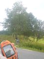
The trees mark the location!
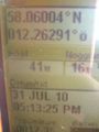
Proof is solid!
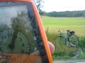
Yet another GPS shot showing the compass, although somewhat outdated.


Achievements
Klibbnisse earned the Consecutive geohash achievement
|
(I almost got the drag-along achievement, but my friend chicken'd out because "it's raining" (which it wasn't) and "I'm sick" (which he probably ain't).