Difference between revisions of "2010-08-05 40 -74"
From Geohashing
imported>Jevanyn (Created page with '{{subst:Expedition|date=2010-08-04|lat=40 |lon=-74}}') |
imported>Jevanyn |
||
| Line 1: | Line 1: | ||
| − | |||
| − | |||
| − | |||
| − | |||
| − | |||
| − | |||
| − | |||
| − | |||
| − | |||
{{meetup graticule | {{meetup graticule | ||
| lat=40 | | lat=40 | ||
| lon=-74 | | lon=-74 | ||
| − | | date=2010-08- | + | | date=2010-08-05 |
}} | }} | ||
| − | |||
__NOTOC__ | __NOTOC__ | ||
== Location == | == Location == | ||
| − | + | Hillsborough, near Six Mile Run. | |
== Participants == | == Participants == | ||
| − | + | Kyukket | |
| − | |||
| − | |||
| − | |||
== Expedition == | == Expedition == | ||
| − | + | [[User:Jevanyn|Jevanyn]]: My initial recon indicated that there was a freight train line, which would have made it a relatively easy geohash to reach. | |
| − | + | Kyukket: here's what i got...those weren't train tracks on the map - they're power lines...i wasn't going anywhere near them...all i have are a few pics from the nearby intersection and a coordinate reading...there wasn't even a street sign to get a pic of =( | |
| − | |||
== Photos == | == Photos == | ||
| − | |||
| − | |||
| − | |||
<gallery perrow="5"> | <gallery perrow="5"> | ||
| + | Image:PRE 2010-08-05-181009.jpg | Overhead power lines (not train tracks) | ||
| + | Image:PRE 2010-08-05-181116.jpg | Closest intersection | ||
| + | Image:Sendmylocation 2010-05-08 180928.png GPS has an accuracy of ''what?!?'' | ||
</gallery> | </gallery> | ||
== Achievements == | == Achievements == | ||
{{#vardefine:ribbonwidth|800px}} | {{#vardefine:ribbonwidth|800px}} | ||
| − | + | {{Consecutive geohash|user=Kyukket}} | |
| − | |||
| − | |||
| − | |||
| − | |||
| − | |||
| − | |||
| − | |||
| − | |||
| − | |||
| − | |||
[[Category:Expeditions]] | [[Category:Expeditions]] | ||
| − | |||
[[Category:Expeditions with photos]] | [[Category:Expeditions with photos]] | ||
| − | |||
| − | |||
| − | |||
| − | |||
| − | |||
| − | |||
| − | |||
| − | |||
| − | |||
[[Category:Coordinates not reached]] | [[Category:Coordinates not reached]] | ||
| − | |||
| − | |||
[[Category:Not reached - No public access]] | [[Category:Not reached - No public access]] | ||
| − | |||
[[Category:Not reached - Did not attempt]] | [[Category:Not reached - Did not attempt]] | ||
| − | |||
Revision as of 15:14, 7 August 2010
| Thu 5 Aug 2010 in 40,-74: 40.5267251, -74.6645214 geohashing.info google osm bing/os kml crox |
Location
Hillsborough, near Six Mile Run.
Participants
Kyukket
Expedition
Jevanyn: My initial recon indicated that there was a freight train line, which would have made it a relatively easy geohash to reach.
Kyukket: here's what i got...those weren't train tracks on the map - they're power lines...i wasn't going anywhere near them...all i have are a few pics from the nearby intersection and a coordinate reading...there wasn't even a street sign to get a pic of =(
Photos
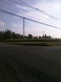
Overhead power lines (not train tracks)
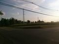
Closest intersection
- Sendmylocation 2010-05-08 180928.png GPS has an accuracy of ''what?!?''


Achievements
This user earned the Consecutive geohash achievement
|