Difference between revisions of "2010-08-10 42 -72"
imported>Sara (expanding subst: expedition) |
imported>FippeBot m (Location) |
||
| (2 intermediate revisions by one other user not shown) | |||
| Line 1: | Line 1: | ||
| − | + | [[Image:{{{image|2010-08-10_42_-72_silly.jpg}}}|thumb|left]] | |
| − | |||
| − | |||
| − | [[Image:{{{image| | ||
| − | |||
| − | |||
| − | |||
| − | |||
| − | |||
| − | |||
{{meetup graticule | {{meetup graticule | ||
| lat=42 | | lat=42 | ||
| Line 14: | Line 5: | ||
| date=2010-08-10 | | date=2010-08-10 | ||
}} | }} | ||
| − | |||
| − | |||
__NOTOC__ | __NOTOC__ | ||
== Location == | == Location == | ||
| − | + | ||
| + | On the side of a suburban road in Westfield, Massachusetts | ||
== Participants == | == Participants == | ||
| − | |||
| − | + | [[User:Sara|Sara]] with her son and daughter | |
| − | |||
== Expedition == | == Expedition == | ||
| − | |||
| − | + | Although, as you may notice from the photos, the children chose to be "t-shirt twins" this afternoon, a conflict began in the car on the way to the Westfield, and by the time we parked near the hashpoint and started walking down the street, they complained that it was too hot and their feet hurt, etc. As soon as I figured out that the hashpint was a little ways off the side of the street in the trees, their eyes lit up "Do we get to go into the woods?" and they eagerly walked three or five meters or into the trees until we found the hashpoint. Then, in an improved mood, they made markers, and then we drove home. | |
| − | + | ||
| + | On the way to and from the hashpoint, we saw [http://terriersaroundtown.com/?page_id=2|"Terriers around Town" in West Springfield], which is like a "cow parade" but with dogs. | ||
| + | |||
== Photos == | == Photos == | ||
| − | + | ||
| − | |||
| − | |||
<gallery perrow="5"> | <gallery perrow="5"> | ||
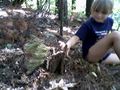
| + | Image:2010-08-10_42_-72_silly.jpg | The children were delighted to get into the trees, even though it was only a few meters from the road. | ||
| + | Image:2010-08-10_42_-72_gps.jpg | We quickly found the hashpoint... | ||
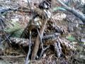
| + | Image:2010-08-10_42_-72_both.jpg | And both children started to build a marker from pinecones and sticks ... | ||
| + | Image:2010-08-10_42_-72_son1.jpg | But it was the kind of afternoon where each child needs to work on their ''own'' XKCD marker. This is my son with his marker. | ||
| + | Image:2010-08-10_42_-72_build.jpg | Here's my daughter working on her marker, before my son's marker fell on it. | ||
| + | Image:2010-08-10_42_-72_marker1.jpg | My daughter took this picture of her rebuilt pine cone marker. | ||
| + | Image:2010-08-10_42_-72_sara.jpg | And then she told me where and how to pose, and took a picture of me. | ||
</gallery> | </gallery> | ||
| − | |||
| − | |||
| − | |||
| − | |||
| − | |||
| − | |||
| − | |||
| − | |||
| − | |||
| − | |||
| − | |||
| − | |||
| − | |||
| − | |||
[[Category:Expeditions]] | [[Category:Expeditions]] | ||
| − | |||
[[Category:Expeditions with photos]] | [[Category:Expeditions with photos]] | ||
| − | |||
| − | |||
| − | |||
| − | |||
| − | |||
[[Category:Coordinates reached]] | [[Category:Coordinates reached]] | ||
| − | + | {{location|US|MA|HD}} | |
| − | |||
| − | |||
| − | |||
| − | |||
| − | |||
| − | |||
| − | |||
| − | |||
| − | |||
Latest revision as of 03:12, 9 August 2019

| Tue 10 Aug 2010 in 42,-72: 42.1114762, -72.7697153 geohashing.info google osm bing/os kml crox |
Location
On the side of a suburban road in Westfield, Massachusetts
Participants
Sara with her son and daughter
Expedition
Although, as you may notice from the photos, the children chose to be "t-shirt twins" this afternoon, a conflict began in the car on the way to the Westfield, and by the time we parked near the hashpoint and started walking down the street, they complained that it was too hot and their feet hurt, etc. As soon as I figured out that the hashpint was a little ways off the side of the street in the trees, their eyes lit up "Do we get to go into the woods?" and they eagerly walked three or five meters or into the trees until we found the hashpoint. Then, in an improved mood, they made markers, and then we drove home.
On the way to and from the hashpoint, we saw "Terriers around Town" in West Springfield, which is like a "cow parade" but with dogs.
Photos
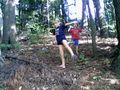
The children were delighted to get into the trees, even though it was only a few meters from the road.
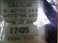
We quickly found the hashpoint...
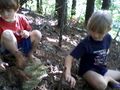
And both children started to build a marker from pinecones and sticks ...
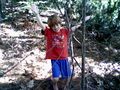
But it was the kind of afternoon where each child needs to work on their own XKCD marker. This is my son with his marker.
Here's my daughter working on her marker, before my son's marker fell on it.
My daughter took this picture of her rebuilt pine cone marker.
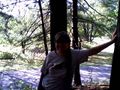
And then she told me where and how to pose, and took a picture of me.


