Difference between revisions of "2010-08-11 40 -104"
From Geohashing
imported>Hoozer |
imported>Hoozer (→About) |
||
| Line 8: | Line 8: | ||
== About == | == About == | ||
| − | + | 9 miles (14.5 km) west of Briggsdale, CO near Weld County Road 61 and Colorado Highway 14 in the Pawnee National Grassland. | |
== Expedition == | == Expedition == | ||
Revision as of 15:03, 12 August 2010
| Wed 11 Aug 2010 in 40,-104: 40.6447452, -104.4959492 geohashing.info google osm bing/os kml crox |
About
9 miles (14.5 km) west of Briggsdale, CO near Weld County Road 61 and Colorado Highway 14 in the Pawnee National Grassland.
Expedition
Hoozer was working near the hashpoint that day, and decided to attempt to reach the hashpoint on his way back home that afternoon. He parked due east of the hashpoint and walked to the hashpoint.
Participants
Stats
Walking distance: 1 mile (1.6 km)
Cows disturbed: 1 herd
Achievements

Pictures
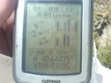
GPS screenshot.
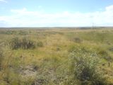
View of the prairie from the hashpoint.

