Difference between revisions of "2010-08-16 42 23"
From Geohashing
imported>Anrieff |
m (per Renaming Proposal) |
||
| (5 intermediate revisions by 3 users not shown) | |||
| Line 1: | Line 1: | ||
| − | |||
| − | |||
| − | |||
| − | |||
| − | |||
| − | |||
| − | |||
| − | |||
| − | |||
{{meetup graticule | {{meetup graticule | ||
| lat=42 | | lat=42 | ||
| Line 20: | Line 11: | ||
== Participants == | == Participants == | ||
| − | Vesko and Ivet | + | [[User:Anrieff|Vesko]] and Ivet |
== Plans == | == Plans == | ||
| − | We plan to go there | + | We plan to go there around 18-19h |
== Expedition == | == Expedition == | ||
| Line 30: | Line 21: | ||
*'''19:30''' :: The GPS software tries to save a few hundred metres by directing us through a very uneven unpaved street, parallel to the main one (in which we are going to merge eventually). At some point we just ignored further directions from the GPS. | *'''19:30''' :: The GPS software tries to save a few hundred metres by directing us through a very uneven unpaved street, parallel to the main one (in which we are going to merge eventually). At some point we just ignored further directions from the GPS. | ||
*'''19:35''' :: Parking, it's close, let's go! | *'''19:35''' :: Parking, it's close, let's go! | ||
| − | *'''19:40''' :: After a short cut through the woods, we enter a field, and reach an offroad-y unpaved road through it - just at the end of the village | + | *'''19:40''' :: After a short cut through the woods (Ivet searched thoroughly for raspberries), we enter a field, and reach an offroad-y unpaved road through it - just at the end of the village |
*'''19:45''' :: We note a interesting hill not far away, and on the top of it there is a stone statue, not much unlike the Easter Island ones! Yay, we may visit this later! (Post-expedition find: this is at [http://maps.google.com/maps?f=q&hl=en&q=42.573454,+23.351230&ie=UTF8&t=h 42°34'24.43"N, 23°21'4.44"E]) | *'''19:45''' :: We note a interesting hill not far away, and on the top of it there is a stone statue, not much unlike the Easter Island ones! Yay, we may visit this later! (Post-expedition find: this is at [http://maps.google.com/maps?f=q&hl=en&q=42.573454,+23.351230&ie=UTF8&t=h 42°34'24.43"N, 23°21'4.44"E]) | ||
*'''19:52''' :: The last car tracks end here, but hashpoint is not far away. | *'''19:52''' :: The last car tracks end here, but hashpoint is not far away. | ||
*'''19:56''' :: Google maps is overoptimistic about the distance from the parking; it's much more than 300m. Anyways, we're here! It seems that the hashpoint is in the middle of a patch of small bushes. | *'''19:56''' :: Google maps is overoptimistic about the distance from the parking; it's much more than 300m. Anyways, we're here! It seems that the hashpoint is in the middle of a patch of small bushes. | ||
*'''19:57''' :: The-patch-of-bushes theory confirmed, but sadly, we didn't bring anything to mark the spot. | *'''19:57''' :: The-patch-of-bushes theory confirmed, but sadly, we didn't bring anything to mark the spot. | ||
| − | *''' | + | *'''20:00''' :: Okay, it's getting dark, let's go back |
| − | *''' | + | *'''20:05''' :: “Should we go to the ''moai''”? “No, let's return, it's getting late, next time” |
| − | *''' | + | *'''20:15''' :: Back in the car, driving to Sofia through Simeonovo. We notice a very nice-looking restaurant with garden on the way Bistrica->Simeonovo, we may visit it someday. |
== Photos == | == Photos == | ||
| Line 45: | Line 36: | ||
<gallery perrow="5"> | <gallery perrow="5"> | ||
| + | Image:2010 08 16 42 23 p2721.jpg | GPS standing by | ||
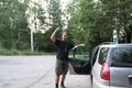
| + | Image:2010 08 16 42 23 p2725.jpg | At the parking near Bistrica | ||
| + | Image:2010 08 16 42 23 p2729.jpg | Ivet is happy to participate | ||
| + | Image:2010 08 16 42 23 p2730.jpg | The wood (no raspberries :() | ||
| + | Image:2010 08 16 42 23 p2732.jpg | Hmm | ||
| + | Image:2010 08 16 42 23 p2733.jpg | A photo using the last sun rays for today | ||
| + | Image:2010 08 16 42 23 p2734.jpg | The ''moai'' is standing there | ||
| + | Image:2010 08 16 42 23 p2735.jpg | Civilization is not far away... | ||
| + | Image:2010 08 16 42 23 p2739.jpg | A view towards Sofia from the hashpoint | ||
| + | Image:2010 08 16 42 23 p2742.jpg | Coordinates confirmed. The last 20 metres are in the bushes | ||
| + | Image:2010 08 16 42 23 p2743.jpg | A lonely tree | ||
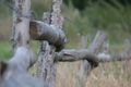
| + | Image:2010 08 16 42 23 p2744.jpg | The hashpoint is over there | ||
| + | Image:2010 08 16 42 23 p2747.jpg | Goin' back. | ||
| + | Image:2010 08 16 42 23 p2751.jpg | The Statue We Didn't Visit | ||
| + | Image:2010 08 16 42 23 p2755.jpg | Civilization, I'm telling you | ||
| + | Image:2010 08 16 42 23 p2757.jpg | Never seen one of those that big! | ||
</gallery> | </gallery> | ||
== Achievements == | == Achievements == | ||
{{#vardefine:ribbonwidth|800px}} | {{#vardefine:ribbonwidth|800px}} | ||
| − | {{ | + | {{Graticule unlocked |
| latitude = 42 | | latitude = 42 | ||
| Line 58: | Line 65: | ||
}} | }} | ||
| − | |||
| − | |||
[[Category:Expeditions]] | [[Category:Expeditions]] | ||
[[Category:Expeditions with photos]] | [[Category:Expeditions with photos]] | ||
[[Category:Coordinates reached]] | [[Category:Coordinates reached]] | ||
| + | {{location|BG|C}} | ||
Latest revision as of 06:07, 20 March 2024
| Mon 16 Aug 2010 in 42,23: 42.5707954, 23.3459473 geohashing.info google osm bing/os kml crox |
Location
The hashpoint is in a field near Bistrica, Sofia. There's an road nearby and a parking (it seems).
Participants
Vesko and Ivet
Plans
We plan to go there around 18-19h
Expedition
- Starting point: "Students' City" district of Sofia.
- 19:10 :: Let's go! We jump in the car and prepare for the 15km drive to Bistrica (which is a village near Sofia), as we set the GPS to navigate us to a parking place we saw from Google Maps, and Google measures it to be 200-300m from the hashpoint.
- 19:30 :: The GPS software tries to save a few hundred metres by directing us through a very uneven unpaved street, parallel to the main one (in which we are going to merge eventually). At some point we just ignored further directions from the GPS.
- 19:35 :: Parking, it's close, let's go!
- 19:40 :: After a short cut through the woods (Ivet searched thoroughly for raspberries), we enter a field, and reach an offroad-y unpaved road through it - just at the end of the village
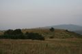
- 19:45 :: We note a interesting hill not far away, and on the top of it there is a stone statue, not much unlike the Easter Island ones! Yay, we may visit this later! (Post-expedition find: this is at 42°34'24.43"N, 23°21'4.44"E)
- 19:52 :: The last car tracks end here, but hashpoint is not far away.
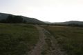
- 19:56 :: Google maps is overoptimistic about the distance from the parking; it's much more than 300m. Anyways, we're here! It seems that the hashpoint is in the middle of a patch of small bushes.
- 19:57 :: The-patch-of-bushes theory confirmed, but sadly, we didn't bring anything to mark the spot.
- 20:00 :: Okay, it's getting dark, let's go back
- 20:05 :: “Should we go to the moai”? “No, let's return, it's getting late, next time”
- 20:15 :: Back in the car, driving to Sofia through Simeonovo. We notice a very nice-looking restaurant with garden on the way Bistrica->Simeonovo, we may visit it someday.
Photos

GPS standing by
At the parking near Bistrica

Ivet is happy to participate
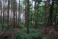
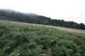
The wood (no raspberries :()

Hmm

A photo using the last sun rays for today
The moai is standing there
Civilization is not far away...
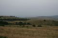
A view towards Sofia from the hashpoint

Coordinates confirmed. The last 20 metres are in the bushes
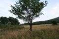
A lonely tree
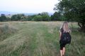
The hashpoint is over there
Goin' back.
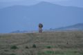
The Statue We Didn't Visit
Civilization, I'm telling you
Never seen one of those that big!


Achievements
Vesko & Ivet earned the Graticule Unlocked Achievement
|