Difference between revisions of "2010-08-20 42 -88"
imported>Bassoon (Created page with '{{subst:Expedition |lat = 42 |lon = -88 |date = 2010-08-20 }}') |
imported>FippeBot m (Location) |
||
| (One intermediate revision by one other user not shown) | |||
| Line 1: | Line 1: | ||
| − | |||
| − | |||
| − | |||
| − | |||
| − | |||
| − | |||
| − | |||
| − | |||
| − | |||
| − | |||
{{meetup graticule | {{meetup graticule | ||
| lat=42 | | lat=42 | ||
| Line 15: | Line 5: | ||
}} | }} | ||
| − | |||
| − | |||
== Location == | == Location == | ||
| − | + | A field at the side of Forest Home Avenue, in Franklin, Wisconsin, also doubling as a homemade bike park. | |
== Participants == | == Participants == | ||
| − | + | * [[User:Bassoon|Bassoon]] | |
| + | * [[User: Dedehawk|Dedehawk]] | ||
== Plans == | == Plans == | ||
| − | + | Show up to the hash, take some photos, mill about suspiciously, and maybe find some geosquishies nearby. | |
== Expedition == | == Expedition == | ||
| − | + | After getting off work, Dedehawk and Bassoon were at a loss for things to do. After a routine check of the daily hashes, we noticed that the hash to the southern graticule was a pretty close hash, which was possibly in a field. As Google Maps isn't updated very often, and due to the pictures that implied construction, we assumed the worst: that someone had built a house on our hash. But we went out anyway, ever the hopeful optimists. | |
| − | + | After getting food at Sonic in Waukesha, we followed I-94 to I-894 and got off. After driving by the hash, Bassoon turned the car around and tried to find somewhere suitable to park. We drove past a really nice park with a gazebo in it, but surely we could find a closer place to park, couldn't we? | |
| − | |||
| + | Indeed we could. We pulled into a tiny subdivision with ridiculous street names like Balboa, South Pacific, West Pacific, and Magellan. Pulling off by the turn around, we parked and got out, ready to face tall grass and harsh trespassing laws to get to our hash. On the way out, we found a nifty ramp. This clearly doubled as a secret bike park. | ||
| + | |||
| + | We wandered farther into the wind-swept, tall grass. Eventually, we wandered into the hash. We took our obligatory group photo and made our way back to the car, making sure to jump off the ramp a few times first. | ||
| + | |||
| + | We found a Speedway shortly after for some squishies worth four stars! | ||
| + | |||
== Photos == | == Photos == | ||
| − | + | ||
| − | |||
| − | |||
<gallery perrow="5"> | <gallery perrow="5"> | ||
| + | Image:2010-08-20 42 -88 ramp.png | What? Is that a RAMP? | ||
| + | Image:2010-08-20 42 -88 field.png | Bassoon wanders around the field, in search of the hash. | ||
| + | Image:2010-08-20 42 -88 victoly.png | "Are we there yet?" "Yes, dammit!" | ||
| + | Image:2010-08-20 42 -88 group.png | Bassoon and Dedehawk pose at the hash. | ||
| + | Image:2010-08-20 42 -88 dedeaction.png | Dedehawk's awesome jumpshot off of the ramp. | ||
| + | Image:2010-08-20 42 -88 bassaction.png | Bassoon's awesome jumpshot off of the ramp. | ||
| + | Image:2010-08-20 42 -88 squish.png | Four-star squishies! | ||
</gallery> | </gallery> | ||
== Achievements == | == Achievements == | ||
{{#vardefine:ribbonwidth|800px}} | {{#vardefine:ribbonwidth|800px}} | ||
| − | + | {{land geohash | |
| − | + | | latitude = 42 | |
| − | + | | longitude = -88 | |
| − | + | | date = 2010-08-20 | |
| − | + | | name = Bassoon and Dedehawk | |
| − | + | | image = 2010-08-20 42 -88 victoly.png | |
| + | }} | ||
| + | {{Minesweeper geohash | ||
| + | | graticule = Fond du Lac, Wisconsin | ||
| + | | ranknumber = 4 | ||
| + | | n = true | ||
| + | | s = true | ||
| + | | w = true | ||
| + | | nw = true | ||
| + | | name = Bassoon and Dedehawk | ||
| + | }} | ||
| − | |||
| − | |||
| − | |||
| − | |||
| − | |||
| − | |||
[[Category:Expeditions]] | [[Category:Expeditions]] | ||
| − | |||
[[Category:Expeditions with photos]] | [[Category:Expeditions with photos]] | ||
| − | + | ||
| − | |||
| − | |||
| − | |||
| − | |||
[[Category:Coordinates reached]] | [[Category:Coordinates reached]] | ||
| − | + | {{location|US|WI|MU}} | |
| − | |||
| − | |||
| − | |||
| − | |||
| − | |||
| − | |||
| − | |||
| − | |||
| − | |||
Latest revision as of 03:23, 9 August 2019
| Fri 20 Aug 2010 in 42,-88: 42.9087523, -88.0584943 geohashing.info google osm bing/os kml crox |
Location
A field at the side of Forest Home Avenue, in Franklin, Wisconsin, also doubling as a homemade bike park.
Participants
Plans
Show up to the hash, take some photos, mill about suspiciously, and maybe find some geosquishies nearby.
Expedition
After getting off work, Dedehawk and Bassoon were at a loss for things to do. After a routine check of the daily hashes, we noticed that the hash to the southern graticule was a pretty close hash, which was possibly in a field. As Google Maps isn't updated very often, and due to the pictures that implied construction, we assumed the worst: that someone had built a house on our hash. But we went out anyway, ever the hopeful optimists.
After getting food at Sonic in Waukesha, we followed I-94 to I-894 and got off. After driving by the hash, Bassoon turned the car around and tried to find somewhere suitable to park. We drove past a really nice park with a gazebo in it, but surely we could find a closer place to park, couldn't we?
Indeed we could. We pulled into a tiny subdivision with ridiculous street names like Balboa, South Pacific, West Pacific, and Magellan. Pulling off by the turn around, we parked and got out, ready to face tall grass and harsh trespassing laws to get to our hash. On the way out, we found a nifty ramp. This clearly doubled as a secret bike park.
We wandered farther into the wind-swept, tall grass. Eventually, we wandered into the hash. We took our obligatory group photo and made our way back to the car, making sure to jump off the ramp a few times first.
We found a Speedway shortly after for some squishies worth four stars!
Photos
What? Is that a RAMP?
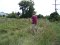
Bassoon wanders around the field, in search of the hash.
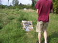
"Are we there yet?" "Yes, dammit!"

Bassoon and Dedehawk pose at the hash.
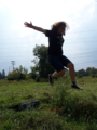
Dedehawk's awesome jumpshot off of the ramp.
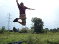
Bassoon's awesome jumpshot off of the ramp.
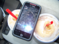
Four-star squishies!


Achievements
Bassoon and Dedehawk earned the Land geohash achievement
|
Bassoon and Dedehawk achieved level 4 of the Minesweeper Geohash achievement
|