Difference between revisions of "2010-08-22 55 13"
imported>Fasanen (Created page with '{{meetup graticule | lat=55 | lon=13 | date=2010-08-22 }} __NOTOC__ == Location == Beddingestrand, Sweden. Open terrain just a meter from a gravel road. == Participants == * […') |
imported>FippeBot m (Location) |
||
| (2 intermediate revisions by one other user not shown) | |||
| Line 16: | Line 16: | ||
== Expedition == | == Expedition == | ||
| − | By looking at the aerial photographs of today's hashpoint, it seemed very easy to reach; in open terrain just a meter from a gravel road. I have been to nearby places before and had a pretty clear view of what landscape was going look like. | + | By looking at the aerial photographs of today's hashpoint, it seemed very easy to reach; in open terrain just a meter from a gravel road. I have been to nearby places before and had a pretty clear view of what landscape was going to look like. |
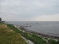
The expedition to the actual hash location was unfortunately as uneventful as I had anticipated. It would have been quite possible to reach the coordinates without even stepping out of the car, but laziness should have it’s limits too so I turned off the engine and got out. There was not a soul in sight. After documenting I went to check out the coastline which was less than a kilometer away and a bit more interesting. | The expedition to the actual hash location was unfortunately as uneventful as I had anticipated. It would have been quite possible to reach the coordinates without even stepping out of the car, but laziness should have it’s limits too so I turned off the engine and got out. There was not a soul in sight. After documenting I went to check out the coastline which was less than a kilometer away and a bit more interesting. | ||
| Line 30: | Line 30: | ||
</gallery> | </gallery> | ||
| + | ==Achievements== | ||
| + | {{land geohash | latitude=55 | longitude=13 | date=2010-08-22 | name=Fasanen }} | ||
[[Category:Expeditions]] | [[Category:Expeditions]] | ||
[[Category:Expeditions with photos]] | [[Category:Expeditions with photos]] | ||
[[Category:Coordinates reached]] | [[Category:Coordinates reached]] | ||
| + | {{location|SE|M}} | ||
Latest revision as of 03:25, 9 August 2019
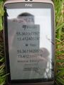
| Sun 22 Aug 2010 in 55,13: 55.3619455, 13.4124052 geohashing.info google osm bing/os kml crox |
Location
Beddingestrand, Sweden. Open terrain just a meter from a gravel road.
Participants
Plans
Nope
Expedition
By looking at the aerial photographs of today's hashpoint, it seemed very easy to reach; in open terrain just a meter from a gravel road. I have been to nearby places before and had a pretty clear view of what landscape was going to look like.
The expedition to the actual hash location was unfortunately as uneventful as I had anticipated. It would have been quite possible to reach the coordinates without even stepping out of the car, but laziness should have it’s limits too so I turned off the engine and got out. There was not a soul in sight. After documenting I went to check out the coastline which was less than a kilometer away and a bit more interesting.
Photos
Proof
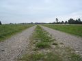
The gravel road at the hash
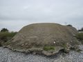
WW2 bunker on the beach in Beddingestrand
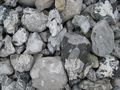
The beach was covered by this kind of stones
Pier


Achievements
Fasanen earned the Land geohash achievement
|