Difference between revisions of "2010-08-24 46 -71"
imported>Sara (expand subst:expedition) |
m (per Renaming Proposal) |
||
| (3 intermediate revisions by 3 users not shown) | |||
| Line 1: | Line 1: | ||
| − | + | [[Image:{{{image|2010-08-24_46_-71_kids.jpg}}}|thumb|left]] | |
| − | |||
| − | |||
| − | [[Image:{{{image| | ||
| − | |||
| − | |||
| − | |||
| − | |||
| − | |||
| − | |||
{{meetup graticule | {{meetup graticule | ||
| lat=46 | | lat=46 | ||
| Line 15: | Line 6: | ||
}} | }} | ||
| − | |||
__NOTOC__ | __NOTOC__ | ||
== Location == | == Location == | ||
| − | + | In a field near a road in Saint-Pierre-Baptiste, Québec. | |
== Participants == | == Participants == | ||
| − | + | [[User:Sara|Sara]] with her daughter and her son. | |
| − | |||
| − | |||
== Expedition == | == Expedition == | ||
| − | |||
| − | + | On the last day of our vacation, we were fortunate enough to get a hashpoint that the kids could get to that was fairly near our route from Québec City to Springfield, MA. My husband drove, but chose to remain in the car instead of walking the last 100 or 200 meters to the hashpoint. | |
| − | + | ||
| + | In the photo of the piggyback ride, it looks as if there was a house nearby, but I didn't see that house at the time, so maybe the house is not really that close. I didn't see anyone to ask for permission, so we simply walked through the mowed fields to the hashpoint and back. Lucky for us, the (drainage?) ditch through which we had to climb had very little water in it, because it has been a very dry summer in Québec. | ||
| + | |||
| + | Really dumb question from a suburbanite: Were the fields mowed or did they look mowed because they were used for grazing? Why would people mow the fields if they aren't going to plant anything in them? To reduce the chance of a fire? To keep the fields in good condition for a future year's planting? | ||
| + | |||
| + | We didn't linger at the hashpoint, because we had a long drive home ahead of us. | ||
| + | |||
| + | After we left the hashpoint and got to a point where the ipad could get Internet access, Google maps suggested that instead of going back to the major highway (Rte. 20) we take a secondary road (Rte. 116) almost all the way back to the U.S. border. This worked out very well for the children, because we were playing a car game where they got points every time they saw a group of animals or a dépanneur (convenience store), and there were plenty of both on the secondary road. | ||
| + | |||
| + | This was a great way to end our vacation. | ||
== Photos == | == Photos == | ||
| − | |||
| − | |||
| − | |||
<gallery perrow="5"> | <gallery perrow="5"> | ||
| + | Image:2010-08-24_46_-71_ski.jpg | We passed a ski area on the way from the highway to the hashpoint. | ||
| + | Image:2010-08-24_46_-71_digger.jpg | An unexpected treat while walking from the car to the hashpoint. | ||
| + | Image:2010-08-24_46_-71_ditch.jpg | My little voyageurs are ready to conquer any hashpoint. (It was actually nowhere near as steep as it looks in this picture.) | ||
| + | Image:2010-08-24_46_-71_daughter.jpg | Before we discovered that we had to climb through the ditch, my daughter complained that there wasn't enough to climb over on the way to this hashpoint. | ||
| + | Image:2010-08-24_46_-71_gps.jpg | Proof of location. (You'll have to take my word for it that we were there on the correct date.) | ||
| + | Image:2010-08-24_46_-71_marker.jpg | That daisy is the marker. Seriously. | ||
| + | Image:2010-08-24_46_-71_view.jpg | View from the hashpoint, looking away from the road. | ||
| + | Image:2010-08-24_46_-71_kids.jpg | View from the hashpoint, looking towards from the road, with the back of my daughter's head. | ||
| + | Image:2010-08-24_46_-71_piggyback.jpg | My daughter took this picture of me giving my son a piggyback ride on the way to the hashpoint. On the way back from the hashpoint, I gave my daughter a piggyback ride, but my son refused to photograph it, because he was holding a special flower that he had found, and he couldn't let either of us hold the flower because he said we didn't know the right way to hold it. | ||
| + | Image:2010-08-24_46_-71_farm.jpg | This was near the geohash, taken from the car. I think my daughter took it. | ||
| + | Image:2010-08-24_46_-71_timbits.jpg | Our post-hash snack, and our way of saying goodbye to Canada (at least until next summer's vacation). | ||
</gallery> | </gallery> | ||
== Achievements == | == Achievements == | ||
{{#vardefine:ribbonwidth|800px}} | {{#vardefine:ribbonwidth|800px}} | ||
| − | + | {{Graticule unlocked | |
| − | + | | latitude = 46 | |
| + | | longitude = -71 | ||
| + | | date = 2010-08-24 | ||
| + | | name = [[User:Sara|Sara]], her son, and her daughter | ||
| + | | image = 2010-08-24_46_-71_ditch.jpg | ||
| + | }} | ||
| − | |||
| − | |||
| − | |||
| − | |||
| − | |||
| − | |||
| − | |||
| − | |||
| − | |||
[[Category:Expeditions]] | [[Category:Expeditions]] | ||
| − | |||
[[Category:Expeditions with photos]] | [[Category:Expeditions with photos]] | ||
| − | |||
| − | |||
| − | |||
| − | |||
| − | |||
[[Category:Coordinates reached]] | [[Category:Coordinates reached]] | ||
| − | + | {{location|CA|QC|17}} | |
| − | |||
| − | |||
| − | |||
| − | |||
| − | |||
| − | |||
| − | |||
| − | |||
| − | |||
Latest revision as of 06:06, 20 March 2024

| Tue 24 Aug 2010 in 46,-71: 46.2207186, -71.6431756 geohashing.info google osm bing/os kml crox |
Location
In a field near a road in Saint-Pierre-Baptiste, Québec.
Participants
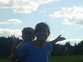
Sara with her daughter and her son.
Expedition
On the last day of our vacation, we were fortunate enough to get a hashpoint that the kids could get to that was fairly near our route from Québec City to Springfield, MA. My husband drove, but chose to remain in the car instead of walking the last 100 or 200 meters to the hashpoint.
In the photo of the piggyback ride, it looks as if there was a house nearby, but I didn't see that house at the time, so maybe the house is not really that close. I didn't see anyone to ask for permission, so we simply walked through the mowed fields to the hashpoint and back. Lucky for us, the (drainage?) ditch through which we had to climb had very little water in it, because it has been a very dry summer in Québec.
Really dumb question from a suburbanite: Were the fields mowed or did they look mowed because they were used for grazing? Why would people mow the fields if they aren't going to plant anything in them? To reduce the chance of a fire? To keep the fields in good condition for a future year's planting?
We didn't linger at the hashpoint, because we had a long drive home ahead of us.
After we left the hashpoint and got to a point where the ipad could get Internet access, Google maps suggested that instead of going back to the major highway (Rte. 20) we take a secondary road (Rte. 116) almost all the way back to the U.S. border. This worked out very well for the children, because we were playing a car game where they got points every time they saw a group of animals or a dépanneur (convenience store), and there were plenty of both on the secondary road.
This was a great way to end our vacation.
Photos
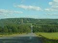
We passed a ski area on the way from the highway to the hashpoint.
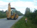
An unexpected treat while walking from the car to the hashpoint.
My little voyageurs are ready to conquer any hashpoint. (It was actually nowhere near as steep as it looks in this picture.)
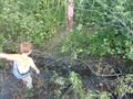
Before we discovered that we had to climb through the ditch, my daughter complained that there wasn't enough to climb over on the way to this hashpoint.
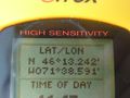
Proof of location. (You'll have to take my word for it that we were there on the correct date.)
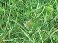
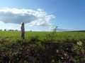
That daisy is the marker. Seriously.
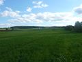
View from the hashpoint, looking away from the road.
View from the hashpoint, looking towards from the road, with the back of my daughter's head.
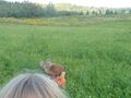
My daughter took this picture of me giving my son a piggyback ride on the way to the hashpoint. On the way back from the hashpoint, I gave my daughter a piggyback ride, but my son refused to photograph it, because he was holding a special flower that he had found, and he couldn't let either of us hold the flower because he said we didn't know the right way to hold it.
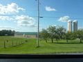
This was near the geohash, taken from the car. I think my daughter took it.
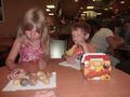
Our post-hash snack, and our way of saying goodbye to Canada (at least until next summer's vacation).


Achievements
Sara, her son, and her daughter earned the Graticule Unlocked Achievement
|