Difference between revisions of "2010-08-26 47 15"
From Geohashing
imported>Atadxart ([live picture] [http://www.openstreetmap.org/?lat=47.278536558151245&lon=15.864896178245544&zoom=16&layers=B000FTF @47.2785,15.8649]) |
m (per Renaming Proposal) |
||
| (18 intermediate revisions by 3 users not shown) | |||
| Line 1: | Line 1: | ||
| + | [[Image:{{{image|2010-08-26_47_15_13-43-57-204.jpg}}}|thumb|left]] | ||
| − | |||
| − | |||
| − | |||
| − | |||
| − | |||
| − | |||
| − | |||
| − | |||
| − | |||
{{meetup graticule | {{meetup graticule | ||
| lat=47 | | lat=47 | ||
| Line 15: | Line 7: | ||
}} | }} | ||
| − | |||
| − | |||
== Location == | == Location == | ||
| − | + | Winzendorf - about 9 km west of Hartberg | |
| + | |||
| + | its an area of a car dealer obviously out of business | ||
== Participants == | == Participants == | ||
| − | + | * [[User:Atadxart|atadxart]] | |
| − | |||
| − | |||
| − | |||
== Expedition == | == Expedition == | ||
<!-- how it all turned out. your narrative goes here. --> | <!-- how it all turned out. your narrative goes here. --> | ||
| − | + | Hello, | |
| − | |||
This is my first geohash | This is my first geohash | ||
| Line 36: | Line 24: | ||
No other hashers in sight | No other hashers in sight | ||
| − | + | I'm happy I made it -- [[User:Atadxart|Atadxart]] [http://www.openstreetmap.org/?lat=47.278536558151245&lon=15.864890813827515&zoom=16&layers=B000FTF @47.2785,15.8649] 13:40, 26 August 2010 (CEST) | |
| − | + | ||
| − | + | I was driving from Gleisdorf to Vienna on the highway and at a stop I checked the graticule and the geohash was not too far away so I stopped by and got may first geohash. | |
== Photos == | == Photos == | ||
| − | + | ||
| − | + | ||
| − | |||
<gallery perrow="5"> | <gallery perrow="5"> | ||
| Line 49: | Line 36: | ||
Image:2010-08-26_47_15_13-42-36-917.jpg | [http://www.openstreetmap.org/?lat=47.278536558151245&lon=15.864896178245544&zoom=16&layers=B000FTF @47.2785,15.8649] | Image:2010-08-26_47_15_13-42-36-917.jpg | [http://www.openstreetmap.org/?lat=47.278536558151245&lon=15.864896178245544&zoom=16&layers=B000FTF @47.2785,15.8649] | ||
| + | |||
| + | Image:2010-08-26_47_15_13-43-57-204.jpg | Its a car dealer but out of business - location is available for rent... [http://www.openstreetmap.org/?lat=47.278536558151245&lon=15.864896178245544&zoom=16&layers=B000FTF @47.2785,15.8649] | ||
| + | |||
| + | Image:2010-08-26_47_15_13-44-32-644.jpg | [http://www.openstreetmap.org/?lat=47.278536558151245&lon=15.864896178245544&zoom=16&layers=B000FTF @47.2785,15.8649] | ||
| + | |||
| + | Image:2010-08-26_47_15_13-48-25-805.jpg | Well thats me [http://www.openstreetmap.org/?lat=47.27862775325775&lon=15.864960551261902&zoom=16&layers=B000FTF @47.2786,15.8650] | ||
</gallery> | </gallery> | ||
== Achievements == | == Achievements == | ||
{{#vardefine:ribbonwidth|800px}} | {{#vardefine:ribbonwidth|800px}} | ||
| − | + | {{land geohash | latitude = 47 | longitude = 15 | date = 2010-08-26 | name = atadxart | image = 2010-08-26_47_15_13-48-25-805.jpg}} | |
| + | {{Graticule unlocked | latitude = 47 | longitude = 15 | date = 2010-08-26 | name = atadxart}} | ||
| − | |||
| − | |||
| − | |||
| − | |||
| − | |||
| − | |||
| − | |||
| − | |||
| − | |||
| − | |||
[[Category:Expeditions]] | [[Category:Expeditions]] | ||
| − | |||
[[Category:Expeditions with photos]] | [[Category:Expeditions with photos]] | ||
| − | |||
| − | |||
| − | |||
| − | |||
| − | |||
[[Category:Coordinates reached]] | [[Category:Coordinates reached]] | ||
| − | + | {{location|AT|ST|HF}} | |
| − | |||
| − | |||
| − | |||
| − | |||
| − | |||
| − | |||
| − | |||
| − | |||
| − | |||
Latest revision as of 06:05, 20 March 2024

| Thu 26 Aug 2010 in 47,15: 47.2785357, 15.8649227 geohashing.info google osm bing/os kml crox |
Location
Winzendorf - about 9 km west of Hartberg
its an area of a car dealer obviously out of business
Participants
Expedition
Hello,
This is my first geohash
No other hashers in sight
I'm happy I made it -- Atadxart @47.2785,15.8649 13:40, 26 August 2010 (CEST)
I was driving from Gleisdorf to Vienna on the highway and at a stop I checked the graticule and the geohash was not too far away so I stopped by and got may first geohash.
Photos
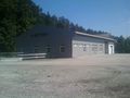
Its a car dealer but out of business - location is available for rent... @47.2785,15.8649

Well thats me @47.2786,15.8650


Achievements
atadxart earned the Land geohash achievement
|
atadxart earned the Graticule Unlocked Achievement
|