Difference between revisions of "2010-08-28 35 -106"
imported>Redaragorn (Created page with '{{meetup graticule | lat=35 | lon=-106 | date=2010-08-28 }} == Location == Steeply sloped pinon-juniper forest about a mile up Bear Canyon on the west side of Sandia Peak. == …') |
imported>Redaragorn (→Pictures) |
||
| Line 30: | Line 30: | ||
Image:2010-08-28 35 -106 - scorpion.jpg|Scorpion I found on my hike up | Image:2010-08-28 35 -106 - scorpion.jpg|Scorpion I found on my hike up | ||
| − | Image:2010-08-28 35 -106 - GPS. | + | Image:2010-08-28 35 -106 - GPS.jpg|GPS coordinates |
Image:2010-08-28 35 -106 - grin.jpg|Grin with the mountain behind me | Image:2010-08-28 35 -106 - grin.jpg|Grin with the mountain behind me | ||
Image:2010-08-28 35 -106 - view.jpg|View down toward the city just a short distance from the hash point | Image:2010-08-28 35 -106 - view.jpg|View down toward the city just a short distance from the hash point | ||
Revision as of 03:05, 29 August 2010
| Sat 28 Aug 2010 in 35,-106: 35.1499209, -106.4496031 geohashing.info google osm bing/os kml crox |
Location
Steeply sloped pinon-juniper forest about a mile up Bear Canyon on the west side of Sandia Peak.
Participants
Plans
I was planning a hike in another part of Sandia for today, but my buddy had to cancel so I decided to head somewhere I hadn't been before and find the hash. Finding the spot looked straightforward enough, although I knew that the mouth of Bear Canyon was private property held by the Albuquerque Academy, so it wasn't quite going to be a simple stroll up the canyon. Ah well...let's give it a go.
Expedition
I wanted to spend time with the family today, so I set the alarm to get up and undertake my expedition early. I got out of the house around 5:30, and was on the trail at the Michel Emery trailhead just before 6a. I took the trails around past the entrance to Bear Canyon, then struck off up the hillside. I was making fairly good progress through the aggressive plants and rough terrain until I started hitting the bigger boulders about 3/4 mile from the hash. I did find an awesome big scorpion that I got a couple of pictures of. Other wildlife encountered included a deer and a bunch of curious hummingbirds. The flora was much less friendly, though--I was being awfully careful, but a few chollas managed to get me anyway. If you notice the long pause on the GPS track, that's where I stopped to pull cholla spines out of my legs. I was feeling pretty good about my progress until I got a quarter mile away from the hash and found another small canyon in my way that I had to go down and up again. I really need to read those topo maps a little closer... Anyway, I finally made it there and got my pictures. I was a little smarter on the trip back and headed up to the top and down again, avoiding much of the roughest going. Whew! So much for a quick and easy hash...gotta remember that bushwhacking is NEVER as easy as it looks.
Track
The track is located here.
Pictures
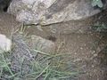
Scorpion I found on my hike up
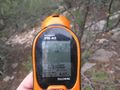
GPS coordinates
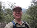
Grin with the mountain behind me
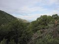
View down toward the city just a short distance from the hash point


