Difference between revisions of "2010-08-29 51 4"
imported>Mr. Pi (→Photos) |
imported>FippeBot m (Location) |
||
| (12 intermediate revisions by 3 users not shown) | |||
| Line 14: | Line 14: | ||
}} | }} | ||
| − | + | ||
__NOTOC__ | __NOTOC__ | ||
== Location == | == Location == | ||
| Line 28: | Line 28: | ||
The hash for today was located right in the waters of the mouth of the port of Rotterdam, so it was obvious that failure was imminent. We decided to try to get as close as possible anyway, because it was quite an interesting location for several reasons: | The hash for today was located right in the waters of the mouth of the port of Rotterdam, so it was obvious that failure was imminent. We decided to try to get as close as possible anyway, because it was quite an interesting location for several reasons: | ||
| − | * The mouth of the river is divided in two. The lower part is the harbor are, with a huge amount of petrochemical industry, while the upper part is the river leading towards Rotterdam. Our 'nearest location' was on the | + | * The mouth of the river is divided in two. The lower part is the harbor are, with a huge amount of petrochemical industry, while the upper part is the river leading towards Rotterdam. Our 'nearest location' was on the separating strip of land between the two, which should make for great views. |
* The hash was located very close to the south door of the [http://en.wikipedia.org/wiki/Maeslantkering Maeslantkering] storm surge barrier. This consists of two Eiffel tower shaped and sized metal doors which can be floated into the river when a storm threatens the land. Incidentally, we visited the storm surge (the visitor center is located at the northern door) when our relation was just a few weeks old. So it made for some sweet memories. | * The hash was located very close to the south door of the [http://en.wikipedia.org/wiki/Maeslantkering Maeslantkering] storm surge barrier. This consists of two Eiffel tower shaped and sized metal doors which can be floated into the river when a storm threatens the land. Incidentally, we visited the storm surge (the visitor center is located at the northern door) when our relation was just a few weeks old. So it made for some sweet memories. | ||
== Expedition == | == Expedition == | ||
| − | We went to the location by car. To keep in the spirit adventure, we didn't use the satnav, but to be honest, reading a map on your smartphone isn't exactly rocket science. The journey took us along the petrochemical industry, ocean ships, wind turbines and nature. Just after the south door of the Maeslantkering, we parked our car ... and then we waited. Normally, a bit of rain doesn't scare us, but this was a completely different category ( | + | We went to the location by car. To keep in the spirit adventure, we didn't use the satnav, but to be honest, reading a map on your smartphone isn't exactly rocket science. The journey took us along the petrochemical industry, ocean ships, wind turbines and nature. Just after the south door of the Maeslantkering, we parked our car ... and then we waited. Normally, a bit of rain doesn't scare us, but this was a completely different |
| + | category. (The weather service reported wind gusts of 80 to 100 km/h along the coast.) | ||
| − | After some time, the torrents seemed to turn into | + | After some time, the torrents seemed to turn into mere rain and we decided to get out of the car. With our umbrellas in horizontal position pointed at the wind, we even managed to stay sort of dry. By walking onto a gangway, we managed to get at 200 meters from the hash at the closest. |
| − | After our visit, we followed the road to the end of the land strip, where the storm made for some pretty nice show of the sea. After a while, the rain started to | + | After our visit, we followed the road to the end of the land strip, where the storm made for some pretty nice show of the sea. After a while, the rain started to subside more and more and we even got some sun breaking through the clouds, so we got treated to some spectacular views. |
All in all, a failed mission but a very nice way to spend our Sunday afternoon. | All in all, a failed mission but a very nice way to spend our Sunday afternoon. | ||
| − | == | + | == Photos == |
| − | |||
| − | + | <gallery> | |
| − | < | ||
| − | |||
| − | |||
| − | |||
Image:2010 08 29 51 4 incar.jpg | Waiting in the car until the rain subsides a bit | Image:2010 08 29 51 4 incar.jpg | Waiting in the car until the rain subsides a bit | ||
Image:2010 08 29 51 4 gps.jpg | 203 meters to destination ... as close as we could get | Image:2010 08 29 51 4 gps.jpg | 203 meters to destination ... as close as we could get | ||
| + | Image:2010 08 29 51 4-lighthouse.jpg | A lighthouse and in the background the Maeslantkering (on the north side of the land strip). | ||
| + | Image:2010 08 29 51 4 morerain.jpg | More rain as we drive to the end of the land strip | ||
| + | Image:2010 08 29 51 4 sea.jpg | View on the sea | ||
| + | Image:2010 08 29 51 4 sailingboat.jpg | A small boat makes it back home while some sun emerges | ||
</gallery> | </gallery> | ||
| − | + | Complete picture set [http://www.flickr.com/photos/mr-pi/sets/72157624918209572/ can be found on Flickr]. | |
| − | |||
| − | |||
| − | |||
| − | |||
| − | |||
| − | |||
| − | |||
| − | |||
| − | |||
| − | |||
| − | |||
| − | |||
| − | |||
[[Category:Expeditions]] | [[Category:Expeditions]] | ||
| − | |||
[[Category:Expeditions with photos]] | [[Category:Expeditions with photos]] | ||
| − | |||
| − | |||
| − | |||
| − | |||
| − | |||
| − | |||
| − | |||
| − | |||
| − | |||
[[Category:Coordinates not reached]] | [[Category:Coordinates not reached]] | ||
| − | |||
[[Category:Not reached - Mother Nature]] | [[Category:Not reached - Mother Nature]] | ||
| − | + | {{location|NL|ZH}} | |
| − | |||
| − | |||
| − | |||
Latest revision as of 03:32, 9 August 2019
| Sun 29 Aug 2010 in 51,4: 51.9542821, 4.1512477 geohashing.info google osm bing/os kml crox |
Location
In the cold deep waters of the Rotterdam harbor.
Participants
- Fred
- Mr. Pi
Our first geohashing adventure!
Plans
We didn't really plan on geohashing in advance, but after we woke up well into the day, we decided we wanted to go outside somewhere. The torrential rains and storm winds were just a tad too much to go for long walks however. After a bit of brainstorming without getting anywhere, we decided to look if maybe this geohashing thing was something to do.
The hash for today was located right in the waters of the mouth of the port of Rotterdam, so it was obvious that failure was imminent. We decided to try to get as close as possible anyway, because it was quite an interesting location for several reasons:
- The mouth of the river is divided in two. The lower part is the harbor are, with a huge amount of petrochemical industry, while the upper part is the river leading towards Rotterdam. Our 'nearest location' was on the separating strip of land between the two, which should make for great views.
- The hash was located very close to the south door of the Maeslantkering storm surge barrier. This consists of two Eiffel tower shaped and sized metal doors which can be floated into the river when a storm threatens the land. Incidentally, we visited the storm surge (the visitor center is located at the northern door) when our relation was just a few weeks old. So it made for some sweet memories.
Expedition
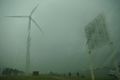
We went to the location by car. To keep in the spirit adventure, we didn't use the satnav, but to be honest, reading a map on your smartphone isn't exactly rocket science. The journey took us along the petrochemical industry, ocean ships, wind turbines and nature. Just after the south door of the Maeslantkering, we parked our car ... and then we waited. Normally, a bit of rain doesn't scare us, but this was a completely different category. (The weather service reported wind gusts of 80 to 100 km/h along the coast.)
After some time, the torrents seemed to turn into mere rain and we decided to get out of the car. With our umbrellas in horizontal position pointed at the wind, we even managed to stay sort of dry. By walking onto a gangway, we managed to get at 200 meters from the hash at the closest.
After our visit, we followed the road to the end of the land strip, where the storm made for some pretty nice show of the sea. After a while, the rain started to subside more and more and we even got some sun breaking through the clouds, so we got treated to some spectacular views.
All in all, a failed mission but a very nice way to spend our Sunday afternoon.
Photos
Waiting in the car until the rain subsides a bit
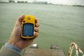
203 meters to destination ... as close as we could get
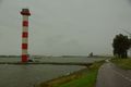
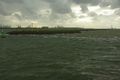
A lighthouse and in the background the Maeslantkering (on the north side of the land strip).
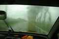
More rain as we drive to the end of the land strip
View on the sea
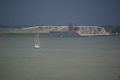
A small boat makes it back home while some sun emerges


Complete picture set can be found on Flickr.