Difference between revisions of "2010-09-03 40 -81"
From Geohashing
imported>Jschleappi ([live picture] Made a stop off and tool this pic at the hash point. Uploaded from my phone. [http://www.openstreetmap.org/?lat=40.894235372543335&lon=-81.91097795963287&zoom=16&layers=B000FTF @40.8942,-81.9110]) |
m (per Renaming Proposal) |
||
| (4 intermediate revisions by 4 users not shown) | |||
| Line 1: | Line 1: | ||
| − | |||
| − | |||
| − | |||
| − | |||
| − | |||
| − | |||
| − | |||
| − | |||
| − | |||
| − | |||
| − | |||
{{meetup graticule | {{meetup graticule | ||
| lat=40 | | lat=40 | ||
| Line 16: | Line 5: | ||
}} | }} | ||
| − | + | ||
__NOTOC__ | __NOTOC__ | ||
== Location == | == Location == | ||
| − | + | ||
Near Wayne County Airport | Near Wayne County Airport | ||
== Participants == | == Participants == | ||
| − | + | ||
*[[User:Jschleappi |Jschleappi ]] | *[[User:Jschleappi |Jschleappi ]] | ||
== Plans == | == Plans == | ||
| − | + | ||
Down from Cleveland. Will format once I'm on a computer... | Down from Cleveland. Will format once I'm on a computer... | ||
== Expedition == | == Expedition == | ||
| − | |||
| − | + | Stopped at home for some new glasses. Checked my Geohashing app and found out this point was just a little off my path on the way home! So i printed out a marker from Active Geohasher and took some pictures! | |
| − | |||
== Photos == | == Photos == | ||
| − | |||
| − | |||
| − | |||
<gallery perrow="5"> | <gallery perrow="5"> | ||
| Line 49: | Line 33: | ||
== Achievements == | == Achievements == | ||
{{#vardefine:ribbonwidth|800px}} | {{#vardefine:ribbonwidth|800px}} | ||
| − | |||
| − | |||
| − | + | {{Land geohash|date=2010-09-03|latitude=40|longitude=-81|name=[[User:Jschleappi |Jschleappi ]]}} | |
| − | + | {{Graticule unlocked|date=2010-09-03|latitude=40|longitude=-81|name=[[User:Jschleappi |Jschleappi ]]}} | |
| − | [[ | ||
| − | |||
| − | |||
| − | |||
| − | |||
| − | |||
[[Category:Expeditions]] | [[Category:Expeditions]] | ||
| − | |||
[[Category:Expeditions with photos]] | [[Category:Expeditions with photos]] | ||
| − | |||
| − | |||
| − | |||
| − | |||
| − | |||
[[Category:Coordinates reached]] | [[Category:Coordinates reached]] | ||
| − | + | {{location|US|OH|WE}} | |
| − | |||
| − | |||
| − | |||
| − | |||
| − | |||
| − | |||
| − | |||
| − | |||
| − | |||
Latest revision as of 06:05, 20 March 2024
| Fri 3 Sep 2010 in 40,-81: 40.8950776, -81.9112729 geohashing.info google osm bing/os kml crox |
Location
Near Wayne County Airport
Participants
Plans
Down from Cleveland. Will format once I'm on a computer...
Expedition
Stopped at home for some new glasses. Checked my Geohashing app and found out this point was just a little off my path on the way home! So i printed out a marker from Active Geohasher and took some pictures!
Photos
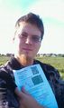
Made a stop off and tool this pic at the hash point. Uploaded from my phone. @40.8942,-81.9110
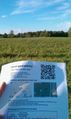
Made a stop off and tool this pic at the hash point. Uploaded from my phone. @40.8942,-81.9110


Achievements
Jschleappi earned the Land geohash achievement
|
Jschleappi earned the Graticule Unlocked Achievement
|