Difference between revisions of "2010-09-11 59 23"
imported>Jusu (→Plans) |
m (per Renaming Proposal) |
||
| (13 intermediate revisions by 2 users not shown) | |||
| Line 1: | Line 1: | ||
| − | |||
<!-- If you did not specify these parameters in the template, please substitute appropriate values for IMAGE, LAT, LON, and DATE (YYYY-MM-DD format) | <!-- If you did not specify these parameters in the template, please substitute appropriate values for IMAGE, LAT, LON, and DATE (YYYY-MM-DD format) | ||
| Line 13: | Line 12: | ||
| lon=23 | | lon=23 | ||
| date=2010-09-11 | | date=2010-09-11 | ||
| + | | graticule_name=Tammisaari, Finland | ||
| + | | graticule_link=Tammisaari, Finland | ||
}} | }} | ||
| Line 18: | Line 19: | ||
__NOTOC__ | __NOTOC__ | ||
== Location == | == Location == | ||
| − | In Tammisaari/Raasepori town, Degerö island, by the side of a gravel road called Jomalvikintie, near Skaldö ferry. | + | In Tammisaari/Raasepori town, Degerö island, by the side of a gravel road called Jomalvikintie, near Skaldö ferry. See [http://kansalaisen.karttapaikka.fi/kartanhaku/koordinaattihaku.html?y=59.9314646&x=23.4966417&srsName=EPSG%3A4258&e=304248&n=6648960&scale=8000&tool=siirra&styles=normal&lang=en&mode=rasta Citizen's Map Site]. |
== Participants == | == Participants == | ||
| Line 24: | Line 25: | ||
== Plans == | == Plans == | ||
| − | Must go there... Hash... | + | Must go there... Hash... HAAASSHH! CHEEEERRRYYY! |
== Expedition == | == Expedition == | ||
| − | + | Drove south to Tammisaari. Visited Lidl and K-supermarket. Then let my Nokia E71's female voice to guide me to the hashpoint. | |
| + | |||
| + | I passed the point to see if there was a good place for car nearby. There wasn't, so I continued one kilometer NW on the same road to see Jomalvik channel. It's a narrow and shallow channel for small boats. The place has been on headlines during the past summer, in a sad way. | ||
| + | |||
| + | As I remember, the story goes like this (facts not checked): Ex-Formula one driver Jyrki Järvilehto, a.k.a. [http://en.wikipedia.org/wiki/JJ_Lehto JJ Lehto], and his friend leave a restaurant in Tammisaari north harbour. They head to JJ's summer house by boat although both are drunk. They decide to take a shortcut via Jomalvik channel. They hit the stone base of a bridge. JJ is injured, his friend dies. Speed limit in the channel is some 10 km/h. Later it has been estimated that their speed had been some 70-80 km/h. It is not known, or at least not yet published, which one steered the boat. JJ says he remembers nothing of the accident. | ||
| + | |||
| + | OK, back to hashing. I drove back. The road was wide enough and there wasn't much traffic, so I left the car on the side of the road. Only one car passed while my stop. The hashpoint was just few meters off the road. The place was almost open with few trees. Dry ground was covered by grasses, heather and bearberry, I think. | ||
| + | |||
| + | Aftrwards I tried to find some geocaches in Tammisaari. Found one, lost interest on searching two micros although surroundings were nice. | ||
| − | == Tracklog == | + | <!--== Tracklog == |
| − | + | if your GPS device keeps a log, you may post a link here --> | |
== Photos == | == Photos == | ||
| Line 36: | Line 45: | ||
Image:2010-##-## ## ## Alpha.jpg | Witty Comment | Image:2010-##-## ## ## Alpha.jpg | Witty Comment | ||
--> | --> | ||
| − | <gallery perrow=" | + | <gallery widths=300px heights=225px perrow="3"> |
| + | Image:2010-09-11 59 23-Jomalvikintie 2067.jpg | Jomalvikintie by the hashpoint | ||
| + | Image:2010-09-11 59 23-Hashpoint to road 2075.jpg | Hashpoint | ||
| + | Image:2010-09-11 59 23-Hashpoint GPS 2072.jpg | Date would be visible on this screen, but "WAAS Averaging" has replaced it. | ||
| + | Image:2010-09-11 59 23-Hashpoint from road 2066.jpg | Hashpoint | ||
| + | Image:2010-09-11 59 23-Hashpoint car 2078.jpg | Hashpoint. Tired already? | ||
| + | Image:2010-09-11 59 23-Jomalvik channel s 2057.jpg | Jomalvik channel, view to the south | ||
| + | Image:2010-09-11 59 23-Jomalvik channel n 2060.jpg | Jomalvik channel, view to the north | ||
| + | Image:2010-09-11 59 23-Jomalvik channel bridge 2064.jpg | Jomalvik channel's bridge. That's where they hit. | ||
| + | Image:2010-09-11 59 23-Jomalvik channel road 2065.jpg | Road over the channel | ||
</gallery> | </gallery> | ||
== Achievements == | == Achievements == | ||
{{#vardefine:ribbonwidth|800px}} | {{#vardefine:ribbonwidth|800px}} | ||
| − | {{ | + | {{Graticule unlocked |
| latitude = 59 | | latitude = 59 | ||
| Line 58: | Line 76: | ||
[[Category:Expeditions]] | [[Category:Expeditions]] | ||
| − | + | [[Category:Expeditions with photos]] | |
[[Category:Coordinates reached]] | [[Category:Coordinates reached]] | ||
| + | {{location|FI|18}} | ||
Latest revision as of 06:03, 20 March 2024
| Sat 11 Sep 2010 in Tammisaari, Finland: 59.9314646, 23.4966417 geohashing.info google osm bing/os kml crox |
Location
In Tammisaari/Raasepori town, Degerö island, by the side of a gravel road called Jomalvikintie, near Skaldö ferry. See Citizen's Map Site.
Participants
Plans
Must go there... Hash... HAAASSHH! CHEEEERRRYYY!
Expedition
Drove south to Tammisaari. Visited Lidl and K-supermarket. Then let my Nokia E71's female voice to guide me to the hashpoint.
I passed the point to see if there was a good place for car nearby. There wasn't, so I continued one kilometer NW on the same road to see Jomalvik channel. It's a narrow and shallow channel for small boats. The place has been on headlines during the past summer, in a sad way.
As I remember, the story goes like this (facts not checked): Ex-Formula one driver Jyrki Järvilehto, a.k.a. JJ Lehto, and his friend leave a restaurant in Tammisaari north harbour. They head to JJ's summer house by boat although both are drunk. They decide to take a shortcut via Jomalvik channel. They hit the stone base of a bridge. JJ is injured, his friend dies. Speed limit in the channel is some 10 km/h. Later it has been estimated that their speed had been some 70-80 km/h. It is not known, or at least not yet published, which one steered the boat. JJ says he remembers nothing of the accident.
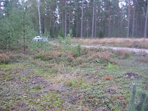
OK, back to hashing. I drove back. The road was wide enough and there wasn't much traffic, so I left the car on the side of the road. Only one car passed while my stop. The hashpoint was just few meters off the road. The place was almost open with few trees. Dry ground was covered by grasses, heather and bearberry, I think.
Aftrwards I tried to find some geocaches in Tammisaari. Found one, lost interest on searching two micros although surroundings were nice.
Photos
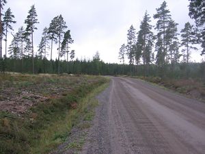
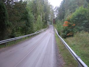
Jomalvikintie by the hashpoint
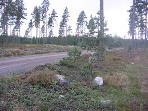
Hashpoint
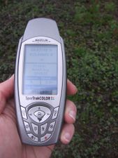
Date would be visible on this screen, but "WAAS Averaging" has replaced it.
Hashpoint
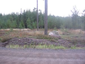
Hashpoint. Tired already?
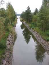
Jomalvik channel, view to the south
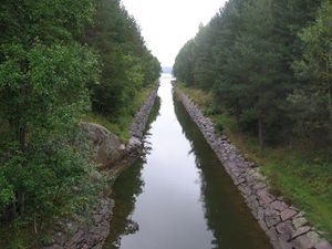
Jomalvik channel, view to the north
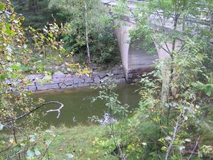
Jomalvik channel's bridge. That's where they hit.
Road over the channel


Achievements
Jusu earned the Graticule Unlocked Achievement
|
Jusu achieved level 2 of the Minesweeper Geohash achievement
|