Difference between revisions of "2010-09-14 64 25"
From Geohashing
imported>Ossisanni (Created page with '{{meetup graticule | lat=64 | lon=25 | date=2010-09-14 | graticule_name=Kempele, Finland | graticule_link=Kempele, Finland}} == Location == Middle of forest near Päivärinne vi…') |
imported>FippeBot m (Location) |
||
| Line 44: | Line 44: | ||
[[Category:Expeditions with photos]] | [[Category:Expeditions with photos]] | ||
[[Category:Coordinates reached]] | [[Category:Coordinates reached]] | ||
| + | {{location|FI|14}} | ||
Latest revision as of 03:44, 9 August 2019
| Tue 14 Sep 2010 in Kempele, Finland: 64.8685115, 25.9063948 geohashing.info google osm bing/os kml crox |
Location
Middle of forest near Päivärinne village in Muhos town.
Participant
Plans
Just go there after work, around 16:30 (UTC+2).
Expedition
After my long working day I converged towards Muhos. I drove road 22 around 25km before turned to forest road. Around one kilometer of that road and I found parking place on a field. My phone showed a hash point to be in 250 meter. There were no any path to take, so I headed to forest. I quickly reach a point, took couple of pictures and came back to car. On my way back I found abandoned house.
Tracklog
Photos
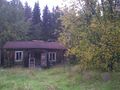
Abandoned house near hash point
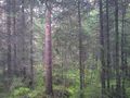
Just forest in hash point
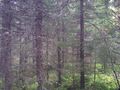
Another picture from forest


Achievements
Ossisanni earned the Land geohash achievement
|