Difference between revisions of "2010-09-15 40 -89"
imported>Dvdllr |
imported>FippeBot m (Location) |
||
| Line 41: | Line 41: | ||
[[Category:Expeditions with photos]] | [[Category:Expeditions with photos]] | ||
[[Category:Coordinates reached]] | [[Category:Coordinates reached]] | ||
| + | {{location|US|IL|WO}} | ||
Latest revision as of 03:34, 6 August 2019
| Wed 15 Sep 2010 in 40,-89: 40.7803981, -89.5340044 geohashing.info google osm bing/os kml crox |
Location
In a weedy field near a residential area, northeast of Peoria, near Spring Bay.
Participants
Plans
Plans for this expedition were short and typical: drive there with camera, GPS, and flag, and see what it looks like. Satellite and Bird's Eye views weren't overly revealing; it looked like this could be a simple grassy field, but it could also have been an untilled and weedy crop field when the images were captured, leaving me to find crops ready for harvest when I got there. I just had to go there and find out.
Expedition
After getting a mile away from home and going back for the forgotten camera, I headed up the Illinois River Trail towards the town of Spring Bay. I turned into a somewhat remote subdivision, where at the end lay the field with the hashpoint. I arrived and was pleased to find it was, in fact, not a crop field, but an unkempt lot with overgrown weeds and such. I walked out there with the GPS and camera, and managed to find the spot without trouble. That's all there was to it, I took some photos and heading out back home.
Photos
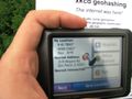
Made it within 10,000ths of a degree
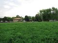
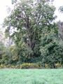
From the hashpoint, looking towards the residences
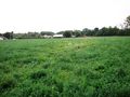
Looking east
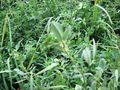
Vegetation
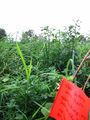
A flag in the wilderness
Look close, my flag is barely visible at the bottom

Back at the car, the victorious geohasher


Achievements
Dvdllr earned the Land geohash achievement
|