Difference between revisions of "2010-09-25 52 1"
imported>Sourcerer (→Expedition) |
imported>Sourcerer |
||
| Line 14: | Line 14: | ||
[[User:Sourcerer|Sourcerer]] | [[User:Sourcerer|Sourcerer]] | ||
| − | == Expedition == | + | == Expedition Plans == |
This is a planned expedition. Neil might aim for the 4pm slot if the weather looks OK. Water wings and a drowned rat costume might come in handy. High winds are forecast so be prepared for a Mother Nature abort. | This is a planned expedition. Neil might aim for the 4pm slot if the weather looks OK. Water wings and a drowned rat costume might come in handy. High winds are forecast so be prepared for a Mother Nature abort. | ||
07:30 is low tide (missed it). 18:30 is the next low tide. It's a full moon spring tide so the sea will go out further than normal. | 07:30 is low tide (missed it). 18:30 is the next low tide. It's a full moon spring tide so the sea will go out further than normal. | ||
| + | |||
| + | == Expedition - Failed == | ||
| + | |||
| + | Neil got to Aldeburgh at about 18:15 and walked to within 24 metes of the hashpoint. The sea was rough and the beach sloped away quickly so a paddle was out of the question. | ||
| + | |||
| + | A fish and chip supper improved the despondent mood although the plaice was dried out. The best fish and chip shops cook the fish, fresh for each order. This takes an extra five minutes but it's worth it. | ||
| + | |||
| + | After the food, Neil tried again and got to within 21 metres. | ||
| + | |||
| + | On dry land in an open space or field, this might count as success as the last few metres could obviously be completed. Today Neil only gets consolation prizes. | ||
| + | |||
| + | The sea was too rough for safe paddling ... | ||
| + | {{mnb geohash | ||
| + | | latitude = 52 | ||
| + | | longitude = 1 | ||
| + | | date = 2010-09-25 | ||
| + | | name = Sourcerer | ||
| + | }} | ||
| + | ... so Neil chickened out. | ||
| + | {{Prize poultry | ||
| + | | latitude = 52 | ||
| + | | longitude = 1 | ||
| + | | date = date 2010-09-25 | ||
| + | | name = Sourcerer | ||
| + | }} | ||
| + | |||
| + | == Photo Gallery == | ||
| + | |||
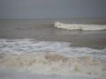
| + | <gallery perrow="3"> | ||
| + | Image:2010-09-25 52 1 Sourcerer.jpg|Rough Sea - This gives no idea of the scale! | ||
| + | </gallery> | ||
| + | |||
| + | [[Category:Expeditions with photos]] | ||
| + | [[Category:Coordinates not reached]] | ||
| + | [[Category:Meetup on 2010-09-25]] | ||
| + | [[Category:Meetup in 52 1]] | ||
Revision as of 19:21, 25 September 2010
Location
Paddle out to the hashpoint from Aldeburgh beach.
| Sat 25 Sep 2010 in Norwich: 52.1473902, 1.6022272 geohashing.info google osm bing/os kml crox |
Participants
Expedition Plans
This is a planned expedition. Neil might aim for the 4pm slot if the weather looks OK. Water wings and a drowned rat costume might come in handy. High winds are forecast so be prepared for a Mother Nature abort.
07:30 is low tide (missed it). 18:30 is the next low tide. It's a full moon spring tide so the sea will go out further than normal.
Expedition - Failed
Neil got to Aldeburgh at about 18:15 and walked to within 24 metes of the hashpoint. The sea was rough and the beach sloped away quickly so a paddle was out of the question.
A fish and chip supper improved the despondent mood although the plaice was dried out. The best fish and chip shops cook the fish, fresh for each order. This takes an extra five minutes but it's worth it.
After the food, Neil tried again and got to within 21 metres.
On dry land in an open space or field, this might count as success as the last few metres could obviously be completed. Today Neil only gets consolation prizes.
The sea was too rough for safe paddling ... Template:Mnb geohash ... so Neil chickened out.
Sourcerer earned the Prize poultry Consolation Prize
|
Photo Gallery
Rough Sea - This gives no idea of the scale!
