Difference between revisions of "2010-10-05 66 25"
From Geohashing
imported>Isopekka |
imported>FippeBot m (Location) |
||
| (5 intermediate revisions by 2 users not shown) | |||
| Line 1: | Line 1: | ||
<!-- If you did not specify these parameters in the template, please substitute appropriate things for IMAGE, LAT, LON, and DATE (YYYY-MM-DD format) | <!-- If you did not specify these parameters in the template, please substitute appropriate things for IMAGE, LAT, LON, and DATE (YYYY-MM-DD format) | ||
| − | [[Image: | + | |
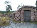
| + | [[Image:Gh10 005.JPG|thumb|left]] | ||
Remove this section if you don't want a image at the top (left) of your report. You should remove the "Image:" or "File:" | Remove this section if you don't want a image at the top (left) of your report. You should remove the "Image:" or "File:" | ||
| Line 8: | Line 9: | ||
And DON'T FORGET to add your expedition and the best photo you took to the gallery on the Main Page! We'd love to read your report, but that means we first have to discover it! | And DON'T FORGET to add your expedition and the best photo you took to the gallery on the Main Page! We'd love to read your report, but that means we first have to discover it! | ||
--> | --> | ||
| + | |||
| + | [[Image:Gh10 005.JPG|thumb|left]] | ||
| + | |||
{{meetup graticule | {{meetup graticule | ||
| lat=66 | | lat=66 | ||
| Line 40: | Line 44: | ||
* Walking total 1.2 km | * Walking total 1.2 km | ||
* By car total about 12 km | * By car total about 12 km | ||
| − | * Expedition took | + | * Expedition took 1 hour |
* Physical efforts needed (1-5): 1 | * Physical efforts needed (1-5): 1 | ||
| − | |||
| − | |||
==Photos == | ==Photos == | ||
| − | < | + | <gallery perrow=4> |
Image:Gh10 001.JPG| On the way to Hashpoint. | Image:Gh10 001.JPG| On the way to Hashpoint. | ||
| Line 57: | Line 59: | ||
Image:Gh10 010.JPG| Hasher at zero point | Image:Gh10 010.JPG| Hasher at zero point | ||
| − | </ | + | </gallery> |
== Achievements == | == Achievements == | ||
| + | |||
| + | {{land geohash | ||
| + | |||
| + | | latitude = 66 | ||
| + | | longitude = 25 | ||
| + | | date = 2010-10-05 | ||
| + | | name = isopekka | ||
| + | |||
| + | }} | ||
| + | == Other Geohashing Expeditions and Plans on This Day == | ||
| + | {{expedition summaries|2010-10-05}} | ||
[[Category:Expeditions]] | [[Category:Expeditions]] | ||
| − | + | [[Category:Coordinates reached]] | |
| − | [[Category: | + | [[Category:Expeditions with photos]] |
| + | {{location|FI|10}} | ||
Latest revision as of 04:02, 9 August 2019

| Tue 5 Oct 2010 in 66,25: 66.5286669, 25.8724088 geohashing.info google osm bing/os kml crox |
Contents
Location
About 6 km from my home location, this is a must!
Participants
- isopekka & Tintti & dog
Expedition
We went after work about 4 p.m. with dog to the city forest. At the hashpoint we were 4:45 p.m. Hashpoint located in very quiet forest although there was plenty of houses surrounding the forest.
- Walking total 1.2 km
- By car total about 12 km
- Expedition took 1 hour
- Physical efforts needed (1-5): 1
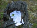
Photos
On the way to Hashpoint.
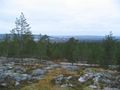
View to the town. 400 m to the Hash.
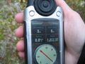
The proof with my new GPS
View from the hashpoint.
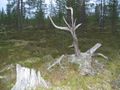
Hashpoint marked.
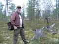
Hasher at zero point


Achievements
isopekka earned the Land geohash achievement
|
Other Geohashing Expeditions and Plans on This Day
Expeditions and Plans
| 2010-10-05 | ||
|---|---|---|
| Paducah, Kentucky | Spork (on a bike) | Maps indicated a residential dead end of some sort, probably cul de sac or ... |
| Grand Junction, Colorado | MessyHair42 | was out in the desert close to the Gunnison River |
| Smoky Lake, Alberta | B cereus | Smack dab in the middle of Range Road 180, just South East of Smokey Lake, ... |
| Rovaniemi, Finland | isopekka | About 6 km from my home location, this is a must! |