Difference between revisions of "2010-10-10 60 24"
imported>PekkaR |
imported>FippeBot m (Location) |
||
| (3 intermediate revisions by 2 users not shown) | |||
| Line 1: | Line 1: | ||
| − | |||
| − | |||
| − | |||
| − | |||
| − | |||
| − | |||
| − | |||
| − | |||
| − | |||
{{meetup graticule | {{meetup graticule | ||
| lat=60 | | lat=60 | ||
| Line 14: | Line 5: | ||
}} | }} | ||
| − | |||
__NOTOC__ | __NOTOC__ | ||
== Location == | == Location == | ||
| − | |||
Today's hashpoint is in Hausjärvi in Puujaa village near the bank of river Puujoki [http://kansalaisen.karttapaikka.fi/linkki?scale=8000&text=hash+10-10-10&srs=EPSG%3A3067&y=6745942&mode=rasta&x=387823&lang=fi[Karttapaikka map]]. | Today's hashpoint is in Hausjärvi in Puujaa village near the bank of river Puujoki [http://kansalaisen.karttapaikka.fi/linkki?scale=8000&text=hash+10-10-10&srs=EPSG%3A3067&y=6745942&mode=rasta&x=387823&lang=fi[Karttapaikka map]]. | ||
| Line 24: | Line 13: | ||
== Participants == | == Participants == | ||
| − | |||
* [[User:PekkaR|PekkaR]] | * [[User:PekkaR|PekkaR]] | ||
== Plans == | == Plans == | ||
| − | + | My Consecutive geohash still continues on fourth day. I'm gonna search also some geocaches because on this special day 10-10-10 the geocaching community is attempting to break the record for number of accounts that logged caches in a single day. Geocaching has also been going on now ten years. I've been a cacher eight years. | |
| − | My Consecutive geohash still continues on fourth day. I'm gonna search also some geocaches because on this special day 10-10-10 the geocaching community is attempting to break the record for number of accounts that logged caches in a single day. Geocaching | ||
---- | ---- | ||
| Line 35: | Line 22: | ||
== Expedition == | == Expedition == | ||
| − | + | It was a beautiful autumn day, sun was shining but wind was quite strong - flying leaves. The trip via Riihimäki took about 40 minutes. When I tried to take the first photo, my camera was dead. No wonder, the battery was on charge at home. Fortunately there is some kind of camera in my mobile phone too. | |
| − | It was a beautiful autumn day, sun was shining but wind was quite strong - flying leaves. The trip via Riihimäki took about 40 minutes. When I tried to take first photo, my camera was dead. No wonder, battery was | ||
| − | + | The walk to the hashpoint was about half a kilometre, first on path and then in forest. The hashpoint was 50 metres from the bank of the river Puujoki. It was about 2:40 pm when I reached the place. I took some ten photos of the GPSr. I noticed at home that mobile phone cameras don't take close-ups. | |
| − | I walked to the river and hiked another route to the car. On the way home I searched half a dozen geocaches. | + | I walked to the river and hiked by another route to the car. On the way home I searched for half a dozen geocaches. |
---- | ---- | ||
| Line 50: | Line 36: | ||
== Tracklog == | == Tracklog == | ||
| − | |||
<gallery perrow="5"> | <gallery perrow="5"> | ||
Image:2010-10-10_60-24_track.gif | Tracklog | Image:2010-10-10_60-24_track.gif | Tracklog | ||
| Line 56: | Line 41: | ||
== Photos == | == Photos == | ||
| − | < | + | <gallery perrow="6"> |
| − | Image:2010- | + | Image:2010-10-10_60-24_gps.jpg | GPSr. The best photo I could get with my mobile phone |
| − | -- | + | Image:2010-10-10_60-24_linden.jpg | Linden leaves |
| − | + | Image:2010-10-10_60-24_elkshit.jpg | Fresh elkshit | |
| + | Image:2010-10-10_60-24_northeast.jpg | View to northeast | ||
| + | Image:2010-10-10_60-24_southwest.jpg | View to southwest | ||
| + | Image:2010-10-10_60-24_river.jpg | River Puujoki | ||
| + | Image:2010-10-10_60-24_bomull.jpg | Cotton tree | ||
| + | Image:2010-10-10_60-24_boat.jpg | River boat? | ||
| + | Image:2010-10-10_60-24_autumn.jpg | Autumn forest | ||
| + | Image:2010-10-10_60-24_panorama.jpg | Panorama | ||
| + | Image:2010-10-10_60-24_landscape.jpg | Rural landscape | ||
</gallery> | </gallery> | ||
== Achievements == | == Achievements == | ||
{{#vardefine:ribbonwidth|800px}} | {{#vardefine:ribbonwidth|800px}} | ||
| − | + | {{consecutive geohash | count = 4 | latitude = 61 | longitude = 24 | date = 2010-10-07 | name = PekkaR }} | |
| − | |||
| − | |||
| − | |||
| − | |||
| − | |||
| − | |||
| − | |||
| − | |||
| − | |||
| − | |||
| − | |||
[[Category:Expeditions]] | [[Category:Expeditions]] | ||
| − | |||
[[Category:Expeditions with photos]] | [[Category:Expeditions with photos]] | ||
| − | |||
| − | |||
| − | |||
| − | |||
| − | |||
[[Category:Coordinates reached]] | [[Category:Coordinates reached]] | ||
| − | + | [[Category:Pages in Finnish]] | |
| − | + | {{location|FI|06}} | |
| − | |||
| − | [[Category: | ||
| − | |||
| − | |||
| − | |||
| − | |||
| − | |||
| − | |||
Latest revision as of 04:11, 9 August 2019
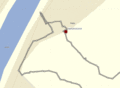
| Sun 10 Oct 2010 in 60,24: 60.8328899, 24.9365460 geohashing.info google osm bing/os kml crox |
Location
Today's hashpoint is in Hausjärvi in Puujaa village near the bank of river Puujoki [Karttapaikka map].
Päivän hässipiste sijaitsee Hausjärven Puujaassa melkein Puujoen rantapenkalla [Karttapaikka].
Participants
Plans
My Consecutive geohash still continues on fourth day. I'm gonna search also some geocaches because on this special day 10-10-10 the geocaching community is attempting to break the record for number of accounts that logged caches in a single day. Geocaching has also been going on now ten years. I've been a cacher eight years.
Hässäilyputkea pitää jatkaa vielä neljäntenä päivänä ja samalla etsiä muutama geokätkö. Tänä erikoisena päivänä 10.10.10 on tarkoitus rikkoa geokätköilyn päivittäisten loggausten ennätys. Kätköilyä on myös harrastettu nyt kymmenen vuotta, itse olen kätköillyt kahdeksan vuotta.
Expedition
It was a beautiful autumn day, sun was shining but wind was quite strong - flying leaves. The trip via Riihimäki took about 40 minutes. When I tried to take the first photo, my camera was dead. No wonder, the battery was on charge at home. Fortunately there is some kind of camera in my mobile phone too.
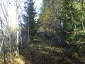
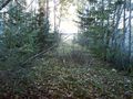
The walk to the hashpoint was about half a kilometre, first on path and then in forest. The hashpoint was 50 metres from the bank of the river Puujoki. It was about 2:40 pm when I reached the place. I took some ten photos of the GPSr. I noticed at home that mobile phone cameras don't take close-ups.
I walked to the river and hiked by another route to the car. On the way home I searched for half a dozen geocaches.
Oli kaunis syyspäivä, aurinko paistoi, tuuli oli aika voimakas. Lehdet saivat kyytiä. Ajomatka Riihimäen kautta kesti noin 40 minuuttia, muutama minuutti tuli kirittyä navigaattorin laskemasta ajasta. Parkkipaikka löytyi rojuvaraston laidalta. Kun piti ottaa ensimmäinen valokuva haavanlehtimatosta, ei kamera osoittanut mitään elonmerkkejä. Ei ihme akku oli latingissa Hämeenlinnassa! Onneksi kännykässäkin on jonkinmoinen kamera.
Patikkamatka nollapisteeseen oli runsas puoli kilometriä. Aluksi metsätietä ja loppumatka "umpihankea". Metsä oli vaikeakulkuista, risusavotan jälkiä oli maastossa. Hässipiste oli noin viidenkymmenen metrin päässä Puujoelta. Kello oli 14:40 kun pääsin paikalle. Otin puhelimen kameralla kymmenkunta kuvaa gepsistä. Kotona huomasin, että lähikuvat onnistuivat huonosti.
Kävin joen rannassa ja patikoin vähän eri reittiä takaisin. Paluumatka olikin mukavampi - helppokulkuisempi maasto ja hieno kalliokin sattui matkalle. Kotimatkalla etsin puolentusinaa geokätköä.
Tracklog
Tracklog

Photos
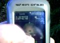
GPSr. The best photo I could get with my mobile phone
Linden leaves
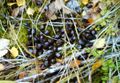
Fresh elkshit
View to northeast
View to southwest
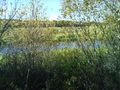
River Puujoki
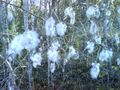
Cotton tree
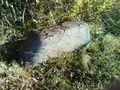
River boat?
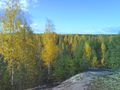
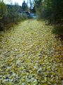
Autumn forest
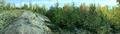
Panorama
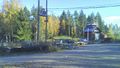
Rural landscape


Achievements
PekkaR earned the Consecutive geohash achievement
|