Difference between revisions of "2010-10-11 61 24"
imported>PekkaR (→Photos) |
imported>PekkaR |
||
| Line 65: | Line 65: | ||
{{#vardefine:ribbonwidth|800px}} | {{#vardefine:ribbonwidth|800px}} | ||
<!-- Add any achievement ribbons you earned below, or remove this section --> | <!-- Add any achievement ribbons you earned below, or remove this section --> | ||
| + | {{consecutive geohash | count = 5 | latitude = 61 | longitude = 24 | date = 2010-10-07 | name = PekkaR }} | ||
<!-- =============== USEFUL CATEGORIES FOLLOW ================ | <!-- =============== USEFUL CATEGORIES FOLLOW ================ | ||
Delete the next line ONLY if you have chosen the appropriate categories below. If you are unsure, don't worry. People will read your report and help you with the classification. --> | Delete the next line ONLY if you have chosen the appropriate categories below. If you are unsure, don't worry. People will read your report and help you with the classification. --> | ||
| − | + | ||
<!-- Potential categories. Please include all the ones appropriate to your expedition --> | <!-- Potential categories. Please include all the ones appropriate to your expedition --> | ||
| Line 79: | Line 80: | ||
[[Category:Expeditions]] | [[Category:Expeditions]] | ||
-- and one or more of -- | -- and one or more of -- | ||
| + | --> | ||
[[Category:Expeditions with photos]] | [[Category:Expeditions with photos]] | ||
| − | + | ||
| − | |||
| − | |||
<!-- if you reached your coords: | <!-- if you reached your coords: | ||
| + | --> | ||
[[Category:Coordinates reached]] | [[Category:Coordinates reached]] | ||
| − | + | ||
<!-- or if you failed :( | <!-- or if you failed :( | ||
Revision as of 18:35, 11 October 2010
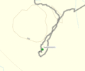
| Mon 11 Oct 2010 in 61,24: 61.2675189, 24.4204779 geohashing.info google osm bing/os kml crox |
Location
In the Finnish woods in Padasjoki near road Vuolijoentie [Karttapaikka map].
Suomalaisessa metsässä Padasjoella Vuolijoentien lähistöllä [Karttapaikka].
Participants
Plans
My Consecutive geohash still continues on fifth day. I decided to go after work to Padasjoki.
Hässäilyputkea pitää jatkaa vielä viidentenä päivänä. Päätin lähteä töiden jälkeen Padasjoelle.
Expedition
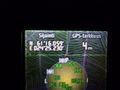
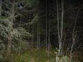
The hashpoint is near crossing of road 57 and highway 12. The trip took about 40 minutes. Sun has already set when I parked my car. In a dusk forest I hiked to the point guided by my Garmin. Surroundings was a typical Finnish woods, plenty of spruces. I arrived to the hashpoint at 6:44 pm. I took some photos and turned back to my car. Now it was already dark but I have allways a flashlight in pocket. Usual Finnish place was seen.
Hässipiste on lähellä Pälkäneentien 57 ja Lahdentien VT12 risteystä. Matka Hämeenlinnasta kesti noin 40 minuuttia. Aurinko oli jo laskeutunut kun ajoin auton parkkiin. Hämärässä metsässä talsin gepsin ohjaamana kohti nollapistettä. Maasto oli tyypillistä suomalaista metsää, paljon kuusia. Saavuin hässipisteelle klo 18:44. Otin muutaman kuvan salaman avulla ja lähdin takaisin autolle. Nyt alkoi jo olla pimeää ja taskulamppu oli tarpeen. Tavanomainen hässipiste oli bongattu.
Tracklog
Tracklog

Photos
GPSr
Dark forest 1
Dark forest 2
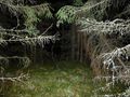
Dark forest 3
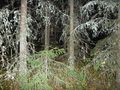
Dark forest 4
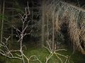
Dark forest 5
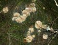
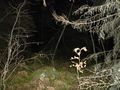
Mushrooms "lampaankääpä" = Albatrellus ovinus


Achievements
PekkaR earned the Consecutive geohash achievement
|