Difference between revisions of "2010-10-19 55 12"
From Geohashing
imported>Fasanen (Created page with '{{meetup graticule | lat=55 | lon=12 | date=2010-10-19 }} __NOTOC__ == Location == Pastureland between Öresund and highway E6/E20, Axeltofta, [[wikipedi…') |
imported>Fasanen (→Photos) |
||
| Line 17: | Line 17: | ||
== Photos == | == Photos == | ||
| − | |||
<gallery perrow="3"> | <gallery perrow="3"> | ||
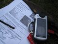
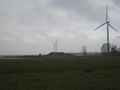
| + | Image:551220101019 01.JPG | Proof | ||
| + | Image:551220101019 02.JPG | Northbound trucks on E6/E20 | ||
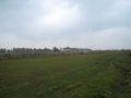
| + | Image:551220101019 03.JPG | Cattle seen in the distant from hash | ||
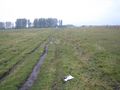
| + | Image:551220101019 04.JPG | Ms. C walking the plank. | ||
| + | Image:551220101019 05.JPG | Happy hashers | ||
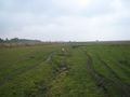
| + | Image:551220101019 06.JPG | Shooting range | ||
</gallery> | </gallery> | ||
| − | |||
[[Category:Expeditions]] | [[Category:Expeditions]] | ||
Revision as of 10:51, 19 October 2010
| Tue 19 Oct 2010 in 55,12: 55.8608726, 12.8830147 geohashing.info google osm bing/os kml crox |
Location
Pastureland between Öresund and highway E6/E20, Axeltofta, Landskrona, Skåne, Sweden.
Participants
- Fasanen & Ms. C
Plans
Expedition
Photos
Proof
Northbound trucks on E6/E20
Cattle seen in the distant from hash
Ms. C walking the plank.

Happy hashers
Shooting range


